
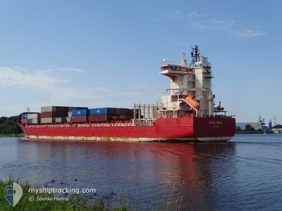
ALEXANDER B
Container Ship
Current Trip
| Time Travelled | 1 day |
|---|---|
| Remaining Time | 1 day |
| Distance Travelled | 385.83 nm |
| Remaining Distance | 417.73 nm |
| AVG Speed | 11.3 Knots |
| MAX Speed | 15.7 Knots |
| AVG Wind | 11.7 knots |
| MAX Wind | 16 knots |
| MIN Temp | 3.2°C / 37.76°F |
| MAX Temp | 7.1°C / 44.78°F |
| Draught | 9.4 m |
| Position Received | 8 h, 1 m ago |
Current Position
| Longitude | --- |
|---|---|
| Latitude | --- |
| Status | Under way using engine |
| Speed | 11.4 Knots |
| Course | 218.5° |
| Area | Baltic Sea |
| Station | T-AIS |
| Position Received | 8 h, 1 m ago |
Info
Information
The current position of ALEXANDER B is in Baltic Sea with coordinates 56.99559° / 18.61718° as reported on 2025-12-05 11:27 by AIS to our vessel tracker app. The vessel's current speed is 11.4 Knots and is heading at the port of BREMERHAVEN. The estimated time of arrival as calculated by MyShipTracking vessel tracking app is 2025-12-07 07:44 LT
The vessel ALEXANDER B (IMO: 9328649, MMSI: 305654000) is a Container Ship that was built in 2006 ( 19 years old ). It's sailing under the flag of [AG] Antigua Barbuda.
In this page you can find informations about the vessels current position, last detected port calls, and current voyage information. If the vessels is not in coverage by AIS you will find the latest position.
The current position of ALEXANDER B is detected by our AIS receivers and we are not responsible for the reliability of the data. The last position was recorded while the vessel was in Coverage by the Ais receivers of our vessel tracking app.
The current draught of ALEXANDER B as reported by AIS is 9.4 meters
Weather
| Temperature | 6.7°C / 44.06°F |
|---|---|
| Wind Speed | 15 knots |
| Direction | 143° SE |
| Pressure | 1013.5 hPa |
| Humidity | 92.2 % |
| Cloud Coverage | 100 % |
Featured Company
Last Port Calls
| Port | Arrival | Departure | Time In Port |
|---|---|---|---|
| 2025-12-03 11:09 | 2025-12-04 12:16 | 1 d | |
| 2025-11-29 14:30 | 2025-11-29 14:33 | 2 m | |
| 2025-11-26 21:50 | 2025-11-29 01:19 | 2 d | |
| 2025-11-25 20:25 | 2025-11-26 03:56 | 7 h | |
| 2025-11-22 22:21 | 2025-11-23 21:50 | 23 h | |
| 2025-11-21 22:12 | 2025-11-22 12:43 | 14 h | |
| 2025-11-18 07:20 | 2025-11-19 15:24 | 1 d | |
| 2025-11-17 10:49 | 2025-11-17 22:04 | 11 h | |
| 2025-11-13 00:08 | 2025-11-13 19:50 | 19 h | |
| 2025-11-05 06:09 | 2025-11-06 17:44 | 1 d |
Last Trips
| Origin | Departure | Destination | Arrival | Distance | |
|---|---|---|---|---|---|
| 2025-11-29 14:33 | 2025-12-03 11:09 | 774.13 nm | |||
| 2025-11-29 01:19 | 2025-11-29 14:30 | 88.33 nm | |||
| 2025-11-26 03:56 | 2025-11-26 21:50 | 117.75 nm | |||
| 2025-11-23 21:50 | 2025-11-25 20:25 | 501.68 nm | |||
| 2025-11-22 12:43 | 2025-11-22 22:21 | 166.88 nm | |||
| 2025-11-19 15:24 | 2025-11-21 22:12 | 509.26 nm | |||
| 2025-11-17 22:04 | 2025-11-18 07:20 | 115.52 nm | |||
| 2025-11-13 19:50 | 2025-11-17 10:49 | 1032.41 nm | |||
| 2025-11-06 17:44 | 2025-11-13 00:08 | 867.73 nm | |||
| 2025-11-04 15:28 | 2025-11-05 06:09 | 140.49 nm |
Events
| Time | Event | Details | Position / Dest | Info |
|---|---|---|---|---|
| 2025-12-05 11:32 | Status Changed | Default Under way using engine |
56.98276 / 18.59887
DEBRV VIA NOK
|
Speed: 11.4 kn Course: 218.5° |
| 2025-12-05 11:27 | Status Changed | Under way using engine Default |
56.99559 / 18.61718
DEBRV VIA NOK
|
Speed: 11.5 kn Course: 218° |
| 2025-12-05 11:27 | OUT of Coverage |
56.99559 / 18.61718
Baltic Sea
DEBRV VIA NOK
|
Speed: 11.4 kn Course: 218.5° |
|
| 2025-12-05 11:20 | Status Changed | Default Under way using engine |
57.01141 / 18.64007
DEBRV VIA NOK
|
Speed: 11.5 kn Course: 218.4° |
| 2025-12-05 09:55 | Status Changed | Under way using engine Default |
57.23133 / 18.93927
DEBRV VIA NOK
|
Speed: 11.4 kn Course: 215° |
| 2025-12-05 09:53 | Status Changed | Default Under way using engine |
57.23569 / 18.94497
DEBRV VIA NOK
|
Speed: 11.3 kn Course: 216.4° |
| 2025-12-05 09:35 | Status Changed | Under way using engine Default |
57.28045 / 19.00549
DEBRV VIA NOK
|
Speed: 11.2 kn Course: 217° |
| 2025-12-05 08:49 | Status Changed | Default Under way using engine |
57.40172 / 19.16936
DEBRV VIA NOK
|
Speed: 12.1 kn Course: 214.6° |
| 2025-12-05 08:28 | Status Changed | Under way using engine Default |
57.45792 / 19.24210
DEBRV VIA NOK
|
Speed: 11.9 kn Course: 215° |
| 2025-12-05 08:25 | Status Changed | Default Under way using engine |
57.46697 / 19.25397
DEBRV VIA NOK
|
Speed: 11.9 kn Course: 214.9° |