
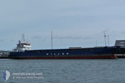
WILSON DUNDEE
General Cargo
Current Trip
| Time Travelled | 6 days |
|---|---|
| Remaining Time | --- |
| Distance Travelled | 775.72 nm |
| Remaining Distance | --- |
| AVG Speed | 8 Knop |
| MAX Speed | 11.4 Knop |
| AVG Wind | 20.6 knots |
| MAX Wind | 32.7 knots |
| MIN Temp | 9.1°C / 48.38°F |
| MAX Temp | 13.8°C / 56.84°F |
| Djupgående | 5.9 m |
| Position mottagen | 1 d sen |
Current Position
| Longitud | --- |
|---|---|
| Latitude | --- |
| Status | Under way using engine |
| Fart | 9.3 Knop |
| Kurs | 240.5° |
| Område | Celtic Sea |
| Station | T-AIS |
| Position mottagen | 1 d sen |
Info
Information
The current position of WILSON DUNDEE is in Celtic Sea with coordinates 49.14482° / -5.22064° as reported on 2025-12-11 01:44 by AIS to our vessel tracker app. The vessel's current speed is 9.3 Knop and is heading at the port of GAETA. The estimated time of arrival as calculated by MyShipTracking vessel tracking app is 2025-12-20 18:00 LT
The vessel WILSON DUNDEE (IMO: 9390159, MMSI: 314635000) is a General Cargo that was built in 2009 ( 16 År gammal ). It's sailing under the flag of [BB] Barbados.
In this page you can find informations about the vessels current position, last detected port calls, and current voyage information. If the vessels is not in coverage by AIS you will find the latest position.
The current position of WILSON DUNDEE is detected by our AIS receivers and we are not responsible for the reliability of the data. The last position was recorded while the vessel was in Coverage by the Ais receivers of our vessel tracking app.
The current draught of WILSON DUNDEE as reported by AIS is 5.9 meters
Weather
| Temperature | 13°C / 55.4°F |
|---|---|
| Wind Speed | 14 knots |
| Direction | 37° NE |
| Pressure | 1025.5 hPa |
| Humidity | 65.8 % |
| Cloud Coverage | 88 % |
Featured Company
Last Port Calls
| Port | Arrival | Departure | Time In Port |
|---|---|---|---|
| 2025-12-04 13:42 | 2025-12-06 12:35 | 1 d | |
| 2025-12-02 11:16 | 2025-12-03 20:10 | 1 d | |
| 2025-11-29 13:02 | 2025-11-30 10:23 | 21 h | |
| 2025-11-28 18:23 | 2025-11-28 19:17 | 53 m | |
| 2025-11-27 20:42 | 2025-11-28 17:12 | 20 h | |
| 2025-11-21 09:18 | 2025-11-24 00:06 | 2 d | |
| 2025-11-11 19:12 | 2025-11-12 17:18 | 22 h | |
| 2025-11-11 10:25 | 2025-11-11 18:34 | 8 h | |
| 2025-11-07 06:32 | 2025-11-09 07:14 | 2 d | |
| 2025-11-01 13:27 | 2025-11-04 01:37 | 2 d |
Most Visited Ports (Last year)
| Port | Arrivals | |
|---|---|---|
| 4 | ||
| 3 | ||
| 3 | ||
| 3 | ||
| 3 | ||
| 2 |
Last Trips
| Origin | Departure | Destination | Arrival | Distance | |
|---|---|---|---|---|---|
| 2025-12-03 20:10 | 2025-12-04 13:42 | 169.04 nm | |||
| 2025-11-30 10:23 | 2025-12-02 11:16 | 319.72 nm | |||
| 2025-11-28 19:17 | 2025-11-29 13:02 | 171.48 nm | |||
| 2025-11-28 17:12 | 2025-11-28 18:23 | 7.82 nm | |||
| 2025-11-24 00:06 | 2025-11-27 20:42 | 849.55 nm | |||
| 2025-11-12 17:18 | 2025-11-21 09:18 | 827.57 nm | |||
| 2025-11-11 18:34 | 2025-11-11 19:12 | 6.04 nm | |||
| 2025-11-09 07:14 | 2025-11-11 10:25 | 456.67 nm | |||
| 2025-11-04 01:37 | 2025-11-07 06:32 | 706.49 nm | |||
| 2025-10-31 12:42 | 2025-11-01 13:27 | 111.58 nm |
Events
| Tid | Event | Detaljer | Position / Dest | Information |
|---|---|---|---|---|
| 2025-12-11 01:49 | Status ändrad | Default Under way using engine |
49.13830 / -5.23745
ITGAE
|
Fart: 9.3 kn Kurs: 240.5° |
| 2025-12-11 01:44 | UTANFÖR täckningsområde |
49.14482 / -5.22064
Celtic Sea
ITGAE
|
Fart: 9.3 kn Kurs: 240.5° |
|
| 2025-12-11 01:40 | Status ändrad | Under way using engine Default |
49.15013 / -5.20672
ITGAE
|
Fart: 9.4 kn Kurs: 238° |
| 2025-12-11 01:30 | Status ändrad | Default Under way using engine |
49.16188 / -5.17627
ITGAE
|
Fart: 8.7 kn Kurs: 239.4° |
| 2025-12-11 01:25 | Upptäckt i hav | French part of the Celtic Sea |
49.16809 / -5.15995
Celtic Sea
ITGAE
|
Fart: 9.2 kn Kurs: 237.3° |
| 2025-12-11 01:25 | Status ändrad | Under way using engine Default |
49.16809 / -5.15995
ITGAE
|
Fart: 8.8 kn Kurs: 236° |
| 2025-12-11 01:06 | I täckningsområde |
49.16809 / -5.15995
Celtic Sea
ITGAE
|
Fart: 9.2 kn Kurs: 237.3° |
|
| 2025-12-10 05:27 | Status ändrad | Default Under way using engine |
50.29805 / -1.37056
ITGAE
|
Fart: 10.9 kn Kurs: 255.2° |
| 2025-12-10 05:20 | UTANFÖR täckningsområde |
50.30416 / -1.33545
English Channel
ITGAE
|
Fart: 10.9 kn Kurs: 255.2° |
|
| 2025-12-10 05:17 | Status ändrad | Under way using engine Default |
50.30633 / -1.32286
ITGAE
|
Fart: 10.9 kn Kurs: 252° |