
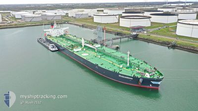
SEAGUARDIAN
Tanker
Current Trip
| Time Travelled | 12 days |
|---|---|
| Remaining Time | --- |
| Distance Travelled | 1489.89 nm |
| Remaining Distance | 4.02 nm |
| AVG Speed | 10.7 Knop |
| MAX Speed | 14.2 Knop |
| AVG Wind | 11.7 knots |
| MAX Wind | 22 knots |
| MIN Temp | 20.6°C / 69.08°F |
| MAX Temp | 29.4°C / 84.92°F |
| Djupgående | 8.3 m |
| Position mottagen | 1 m sen |
Current Position
| Longitud | -75.53153° |
|---|---|
| Latitude | 10.32165° |
| Status | At anchor |
| Fart | |
| Kurs | 20° |
| Område | Caribbean Sea |
| Station | T-AIS |
| Position mottagen | 1 m sen |
Info
Information
The current position of SEAGUARDIAN is in Caribbean Sea with coordinates 10.32165° / -75.53153° as reported on 2024-05-06 08:17 by AIS to our vessel tracker app. The vessel's current speed is 0 Knop and is heading at the port of CARTAGENA. The estimated time of arrival as calculated by MyShipTracking vessel tracking app is 2024-05-05 23:00 LT
The vessel SEAGUARDIAN (IMO: 9891919, MMSI: 538009055) is a Tanker It's sailing under the flag of [MH] Marshall Is.
In this page you can find informations about the vessels current position, last detected port calls, and current voyage information. If the vessels is not in coverage by AIS you will find the latest position.
The current position of SEAGUARDIAN is detected by our AIS receivers and we are not responsible for the reliability of the data. The last position was recorded while the vessel was in Coverage by the Ais receivers of our vessel tracking app.
The current draught of SEAGUARDIAN as reported by AIS is 8.3 meters
Weather
| Temperature | 27.2°C / 80.96°F |
|---|---|
| Wind Speed | 4 knots |
| Direction | 2° N |
| Pressure | 1007.7 hPa |
| Humidity | 87.7 % |
| Cloud Coverage | 100 % |
Featured Company
Last Port Calls
| Port | Arrival | Departure | Time In Port |
|---|---|---|---|
| 2024-04-22 15:26 | 2024-04-23 19:14 | 1 d | |
| 2024-04-17 13:01 | 2024-04-19 00:45 | 1 d | |
| 2024-03-24 14:08 | 2024-03-25 16:38 | 1 d | |
| 2024-03-17 12:54 | 2024-03-24 13:27 | 7 d | |
| 2024-03-15 18:27 | 2024-03-17 12:25 | 1 d |
Most Visited Ports (Last year)
| Port | Arrivals | |
|---|---|---|
| 3 | ||
| 3 | ||
| 2 | ||
| 1 | ||
| 1 | ||
| 1 |
Last Trips
| Origin | Departure | Destination | Arrival | Distance | |
|---|---|---|---|---|---|
| 2024-04-18 19:45 | 2024-04-22 10:26 | 603.53 nm | |||
| 2024-03-25 17:38 | 2024-04-17 08:01 | 5808.87 nm | |||
| 2024-03-24 14:27 | 2024-03-24 15:08 | 3.03 nm | |||
| 2024-03-17 13:25 | 2024-03-17 13:54 | 3.30 nm | |||
| 2024-02-28 20:09 | 2024-03-15 19:27 | 1396.82 nm |
Events
| Tid | Event | Detaljer | Position / Dest | Information |
|---|---|---|---|---|
| 2024-05-06 05:05 | Status ändrad | At anchor Under way using engine |
10.32283 / -75.53264
USPGL-COCTG
|
Fart: Kurs: 69° |
| 2024-05-06 05:03 | STOPPAR förflyttning | 3.97 nm, South of CARTAGENA |
10.32285 / -75.53265
USPGL-COCTG
|
Fart: 0.3 kn Kurs: 68° |
| 2024-05-06 03:01 | Djupgående ändrat | 8.3 8.5 |
10.28606 / -75.74597
USPGL-COCTG
|
Fart: 11.2 kn Kurs: 75.6° |
| 2024-05-06 03:01 | Destination ändrad | USPGL-COCTG USPGL ANCHORAGE |
10.28606 / -75.74597
USPGL-COCTG
|
Fart: 11.2 kn Kurs: 75.6° |
| 2024-05-06 03:01 | ETA ändrat | 2024/05/05 23:00 2024/04/23 16:54 |
10.28606 / -75.74597
USPGL-COCTG
|
Fart: 11.2 kn Kurs: 75.6° |
| 2024-05-06 01:38 | Status ändrad | Under way using engine Default |
10.26458 / -76.03330
USPGL ANCHORAGE
|
Fart: 12.2 kn Kurs: 87° |
| 2024-05-06 01:33 | Status ändrad | Default Under way using engine |
10.26379 / -76.04782
USPGL ANCHORAGE
|
Fart: 12.1 kn Kurs: 86.8° |
| 2024-05-06 01:28 | Byter havsområde | Colombian part of the Caribbean Sea United States part of the Gulf of Mexico |
10.26275 / -76.06721
Caribbean Sea
|
Fart: 11.9 kn Kurs: 87.3° |
| 2024-05-06 01:28 | Status ändrad | Under way using engine Default |
10.26275 / -76.06721
USPGL ANCHORAGE
|
Fart: 11.7 kn Kurs: 121° |
| 2024-05-06 01:28 | I täckningsområde |
10.26275 / -76.06721
Caribbean Sea
|
Fart: 11.9 kn Kurs: 87.3° |