
NEW LEGACY
Cargo
Current Trip
| Time Travelled | 10 days |
|---|---|
| Remaining Time | 6 days |
| Distance Travelled | 2592.92 nm |
| Remaining Distance | 1607.12 nm |
| AVG Speed | 10.8 Knop |
| MAX Speed | 13.6 Knop |
| AVG Wind | 11.9 knots |
| MAX Wind | 28.4 knots |
| MIN Temp | 3.8°C / 38.84°F |
| MAX Temp | 22°C / 71.6°F |
| Djupgående | 8.3 m |
| Position mottagen | 8 d sen |
Current Position
| Longitud | 141.16625° |
|---|---|
| Latitude | 35.32422° |
| Status | Under way using engine |
| Fart | 13 Knop |
| Kurs | 63.3° |
| Område | North Pacific Ocean |
| Station | T-AIS |
| Position mottagen | 8 d sen |
Info
Information
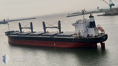
The current position of NEW LEGACY is in North Pacific Ocean with coordinates 35.32422° / 141.16625° as reported on 2024-05-31 16:42 by AIS to our vessel tracker app. The vessel's current speed is 13 Knop and is heading at the port of PRINCE RUPERT. The estimated time of arrival as calculated by MyShipTracking vessel tracking app is 2024-06-15 00:22 LT
The vessel NEW LEGACY (IMO: 9804942, MMSI: 636018067) is a Cargo It's sailing under the flag of [LR] Liberia.
In this page you can find informations about the vessels current position, last detected port calls, and current voyage information. If the vessels is not in coverage by AIS you will find the latest position.
The current position of NEW LEGACY is detected by our AIS receivers and we are not responsible for the reliability of the data. The last position was recorded while the vessel was in Coverage by the Ais receivers of our vessel tracking app.
The current draught of NEW LEGACY as reported by AIS is 8.3 meters
Weather
| Temperature | 4.5°C / 40.1°F |
|---|---|
| Wind Speed | 16 knots |
| Direction | 354° N |
| Pressure | 1012.6 hPa |
| Humidity | 90.8 % |
| Cloud Coverage | 64 % |
Featured Company
Events
| Tid | Event | Detaljer | Position / Dest | Information |
|---|---|---|---|---|
| 2024-05-31 16:46 | Status ändrad | Default Under way using engine |
35.33162 / 141.18408
CAPRR
|
Fart: 13 kn Kurs: 63.3° |
| 2024-05-31 16:42 | Status ändrad | Under way using engine Default |
35.32422 / 141.16625
CAPRR
|
Fart: 12.9 kn Kurs: 63° |
| 2024-05-31 16:42 | UTANFÖR täckningsområde |
35.32422 / 141.16625
North Pacific Ocean
CAPRR
|
Fart: 13 kn Kurs: 63.3° |
|
| 2024-05-31 16:29 | Status ändrad | Default Under way using engine |
35.30441 / 141.11929
CAPRR
|
Fart: 12.9 kn Kurs: 62.6° |
| 2024-05-31 10:37 | Status ändrad | Under way using engine Default |
34.85148 / 139.71363
CAPRR
|
Fart: 11.7 kn Kurs: 167° |
| 2024-05-31 10:34 | I täckningsområde |
34.85144 / 139.71470
North Pacific Ocean
CAPRR
|
Fart: 9.6 kn Kurs: 96.6° |
|
| 2024-05-31 09:02 | Status ändrad | Default Under way using engine |
35.14576 / 139.74692
CAPRR
|
Fart: 12.3 kn Kurs: 197.1° |
| 2024-05-31 08:57 | UTANFÖR täckningsområde |
35.16183 / 139.75294
North Pacific Ocean
CAPRR
|
Fart: 12.3 kn Kurs: 197.1° |
|
| 2024-05-31 08:27 | Status ändrad | Under way using engine Default |
35.24874 / 139.77395
CAPRR
|
Fart: 12.9 kn Kurs: 146° |
| 2024-05-31 08:18 | Status ändrad | Default Under way using engine |
35.27779 / 139.75607
CAPRR
|
Fart: 12.5 kn Kurs: 143.4° |