
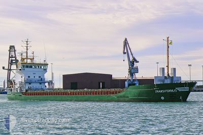
MARAS
General Cargo
Current Trip
| Time Travelled | 1 day |
|---|---|
| Remaining Time | --- |
| Distance Travelled | 0.89 nm |
| Remaining Distance | --- |
| AVG Speed | 9.1 Knop |
| MAX Speed | 9.1 Knop |
| AVG Wind | 6.8 knots |
| MAX Wind | 7 knots |
| MIN Temp | 11.7°C / 53.06°F |
| MAX Temp | 12.2°C / 53.96°F |
| Djupgående | 4 m |
| Position mottagen | 1 d sen |
Current Position
| Longitud | --- |
|---|---|
| Latitude | --- |
| Status | Under way using engine |
| Fart | 9.1 Knop |
| Kurs | 259.7° |
| Område | Adriatic Sea |
| Station | T-AIS |
| Position mottagen | 1 d sen |
Info
Information
The current position of MARAS is in Adriatic Sea with coordinates 44.49977° / 12.43513° as reported on 2025-12-12 16:43 by AIS to our vessel tracker app. The vessel's current speed is 9.1 Knop
The vessel MARAS (IMO: 9195834, MMSI: 304345000) is a General Cargo that was built in 2000 ( 25 År gammal ). It's sailing under the flag of [AG] Antigua Barbuda.
In this page you can find informations about the vessels current position, last detected port calls, and current voyage information. If the vessels is not in coverage by AIS you will find the latest position.
The current position of MARAS is detected by our AIS receivers and we are not responsible for the reliability of the data. The last position was recorded while the vessel was in Coverage by the Ais receivers of our vessel tracking app.
The current draught of MARAS as reported by AIS is 4 meters
Weather
| Temperature | 12.1°C / 53.78°F |
|---|---|
| Wind Speed | 7 knots |
| Direction | 318° NW |
| Pressure | 1024 hPa |
| Humidity | 67.7 % |
| Cloud Coverage | 8 % |
Featured Company
Last Port Calls
| Port | Arrival | Departure | Time In Port |
|---|---|---|---|
| 2025-12-09 07:33 | 2025-12-12 15:30 | 3 d | |
| 2025-12-04 08:17 | 2025-12-04 14:49 | 6 h | |
| 2025-11-21 05:59 | 2025-11-22 11:11 | 1 d | |
| 2025-11-11 14:35 | 2025-11-12 23:10 | 1 d | |
| 2025-11-09 10:19 | 2025-11-09 23:58 | 13 h | |
| 2025-10-18 02:22 | 2025-10-19 05:14 | 1 d | |
| 2025-10-16 17:00 | 2025-10-17 04:00 | 10 h | |
| 2025-10-13 12:14 | 2025-10-14 17:10 | 1 d | |
| 2025-10-06 08:12 | 2025-10-06 16:26 | 8 h | |
| 2025-10-01 07:00 | 2025-10-01 11:19 | 4 h |
Last Trips
| Origin | Departure | Destination | Arrival | Distance | |
|---|---|---|---|---|---|
| 2025-12-04 14:49 | 2025-12-09 07:33 | 711.37 nm | |||
| 2025-11-22 11:11 | 2025-12-04 08:17 | 2375.33 nm | |||
| 2025-11-12 23:10 | 2025-11-21 05:59 | 908.46 nm | |||
| 2025-11-09 23:58 | 2025-11-11 14:35 | 333.80 nm | |||
| 2025-10-19 05:14 | 2025-11-09 10:19 | 3747.05 nm | |||
| 2025-10-17 04:00 | 2025-10-18 02:22 | 79.11 nm | |||
| 2025-10-14 17:10 | 2025-10-16 17:00 | 72.12 nm | |||
| 2025-10-06 16:26 | 2025-10-13 12:14 | 992.96 nm | |||
| 2025-10-01 11:19 | 2025-10-06 08:12 | 993.89 nm | |||
| 2025-09-22 23:13 | 2025-10-01 07:00 | 1445.18 nm |
Events
| Tid | Event | Detaljer | Position / Dest | Information |
|---|---|---|---|---|
| 2025-12-12 16:43 | UTANFÖR täckningsområde |
44.49977 / 12.43513
Adriatic Sea
RAVENNA
|
Fart: 9.1 kn Kurs: 259.7° |
|
| 2025-12-12 16:43 | I täckningsområde |
44.49977 / 12.43513
Adriatic Sea
RAVENNA
|
Fart: 9.1 kn Kurs: 259.7° |
|
| 2025-12-12 14:33 | Djupgående ändrat | 4 6.5 |
44.50222 / 12.45561
RAVENNA
|
Fart: Kurs: 347° |
| 2025-12-12 14:33 | ETA ändrat | 2025/12/12 18:00 2025/12/08 06:00 |
44.50222 / 12.45561
RAVENNA
|
Fart: Kurs: 347° |
| 2025-12-12 14:31 | I täckningsområde |
44.50222 / 12.45561
Adriatic Sea
|
Fart: Kurs: 353° |
|
| 2025-12-12 14:31 | UTANFÖR täckningsområde |
44.50222 / 12.45561
Adriatic Sea
RAVENNA
|
Fart: Kurs: 353° |
|
| 2025-12-12 14:30 | AVGÅTT HAMN |
|
44.50222 / 12.45561
RAVENNA
|
Fart: Kurs: 58° |
| 2025-12-09 07:53 | UTANFÖR täckningsområde |
44.47504 / 12.25765
Adriatic Sea
[IT] RAVENNA
|
Fart: Kurs: 82.7° |
|
| 2025-12-09 07:53 | I täckningsområde |
44.47504 / 12.25765
Adriatic Sea
[IT] RAVENNA
|
Fart: Kurs: 82.7° |
|
| 2025-12-09 06:34 | UTANFÖR täckningsområde |
44.47907 / 12.26352
Adriatic Sea
[IT] RAVENNA
|
Fart: 3 kn Kurs: 212.4° |