
MARAS
General Cargo
Current Trip
| Trip Time | 4 days |
|---|---|
| Trip Distance | 711.37 nm |
| AVG Speed | 7.7 Noeuds |
| MAX Speed | 9.9 Noeuds |
| Tirant d eau | 6.5 m |
| AVG Wind | 15.9 knots |
| MAX Wind | 23 knots |
| MIN Temp | 8.4°C / 47.12°F |
| MAX Temp | 16°C / 60.8°F |
| Position reçue | 15 h, 14 m depuis |
Current Position
| Longitude | --- |
|---|---|
| Latitude | --- |
| Etat | Moored |
| Vitesse | |
| Parcours | 58° |
| Zone | Adriatic Sea |
| Station | T-AIS |
| Position reçue | 15 h, 14 m depuis |
Info
Information
The current position of MARAS is in Adriatic Sea with coordinates 44.47504° / 12.25765° as reported on 2025-12-09 07:53 by AIS to our vessel tracker app. The vessel's current speed is 0 Noeuds and is currently inside the port of RAVENNA.
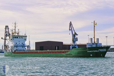
The vessel MARAS (IMO: 9195834, MMSI: 304345000) is a General Cargo that was built in 2000 ( 25 Age ). It's sailing under the flag of [AG] Antigua Barbuda.
In this page you can find informations about the vessels current position, last detected port calls, and current voyage information. If the vessels is not in coverage by AIS you will find the latest position.
The current position of MARAS is detected by our AIS receivers and we are not responsible for the reliability of the data. The last position was recorded while the vessel was in Coverage by the Ais receivers of our vessel tracking app.
The current draught of MARAS as reported by AIS is 6.5 meters
Weather
| Temperature | 8.3°C / 46.94°F |
|---|---|
| Wind Speed | 5 knots |
| Direction | 283° WNW |
| Pressure | 1024.6 hPa |
| Humidity | 72.1 % |
| Cloud Coverage | 100 % |
Featured Company
Last Port Calls
| Port | Arrival | Departure | Time In Port |
|---|---|---|---|
| 2025-12-09 07:33 | |||
| 2025-12-04 08:17 | 2025-12-04 14:49 | 6 h | |
| 2025-11-21 05:59 | 2025-11-22 11:11 | 1 d | |
| 2025-11-11 14:35 | 2025-11-12 23:10 | 1 d | |
| 2025-11-09 10:19 | 2025-11-09 23:58 | 13 h | |
| 2025-10-18 02:22 | 2025-10-19 05:14 | 1 d | |
| 2025-10-16 17:00 | 2025-10-17 04:00 | 10 h | |
| 2025-10-13 12:14 | 2025-10-14 17:10 | 1 d | |
| 2025-10-06 08:12 | 2025-10-06 16:26 | 8 h | |
| 2025-10-01 07:00 | 2025-10-01 11:19 | 4 h |
Last Trips
| Origin | Departure | Destination | Arrival | Distance | |
|---|---|---|---|---|---|
| 2025-12-04 14:49 | 2025-12-09 07:33 | 711.37 nm | |||
| 2025-11-22 11:11 | 2025-12-04 08:17 | 2375.33 nm | |||
| 2025-11-12 23:10 | 2025-11-21 05:59 | 908.46 nm | |||
| 2025-11-09 23:58 | 2025-11-11 14:35 | 333.80 nm | |||
| 2025-10-19 05:14 | 2025-11-09 10:19 | 3747.05 nm | |||
| 2025-10-17 04:00 | 2025-10-18 02:22 | 79.11 nm | |||
| 2025-10-14 17:10 | 2025-10-16 17:00 | 72.12 nm | |||
| 2025-10-06 16:26 | 2025-10-13 12:14 | 992.96 nm | |||
| 2025-10-01 11:19 | 2025-10-06 08:12 | 993.89 nm | |||
| 2025-09-22 23:13 | 2025-10-01 07:00 | 1445.18 nm |
Events
| Heure | Evenement | Détails | Position/ Destination | Info |
|---|---|---|---|---|
| 2025-12-09 07:53 | Hors de la zone couverte |
44.47504 / 12.25765
Adriatic Sea
[IT] RAVENNA
|
Vitesse: Parcours: 82.7° |
|
| 2025-12-09 07:53 | Dans la zone couverte |
44.47504 / 12.25765
Adriatic Sea
[IT] RAVENNA
|
Vitesse: Parcours: 82.7° |
|
| 2025-12-09 06:34 | Hors de la zone couverte |
44.47907 / 12.26352
Adriatic Sea
[IT] RAVENNA
|
Vitesse: 3 kn Parcours: 212.4° |
|
| 2025-12-09 06:33 | Port d'arrivée |
|
44.47907 / 12.26352
[IT] RAVENNA
|
Vitesse: 3.7 kn Parcours: 278° |
| 2025-12-09 05:32 | Démarrage | 5.74 nm, East of MARINA ROMEA |
44.49879 / 12.40500
RAVENNA
|
Vitesse: 3.7 kn Parcours: 278° |
| 2025-12-09 04:43 | Etat Changé | Under way using engine At anchor |
44.50660 / 12.48321
RAVENNA
|
Vitesse: Parcours: 352° |
| 2025-12-09 04:05 | Dans la zone couverte |
44.50607 / 12.48376
Adriatic Sea
|
Vitesse: Parcours: 233.8° |
|
| 2025-12-09 02:33 | Hors de la zone couverte |
44.50610 / 12.48400
Adriatic Sea
|
Vitesse: Parcours: 270.9° |
|
| 2025-12-09 02:33 | Dans la zone couverte |
44.50610 / 12.48400
Adriatic Sea
|
Vitesse: Parcours: 270.9° |
|
| 2025-12-09 01:09 | Hors de la zone couverte |
44.50611 / 12.48386
Adriatic Sea
|
Vitesse: Parcours: 113.6° |