
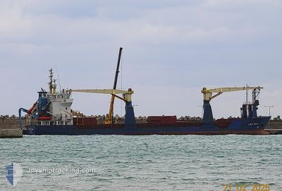
LADY AYAN
General Cargo
Current Trip
| Time Travelled | 6 days |
|---|---|
| Remaining Time | --- |
| Distance Travelled | 393.04 nm |
| Remaining Distance | --- |
| AVG Speed | 6.1 Knop |
| MAX Speed | 12.1 Knop |
| AVG Wind | 18.1 knots |
| MAX Wind | 36 knots |
| MIN Temp | 1°C / 33.8°F |
| MAX Temp | 17.2°C / 62.96°F |
| Djupgående | 3.7 m |
| Position mottagen | 14 h, 17 m sen |
Current Position
| Longitud | --- |
|---|---|
| Latitude | --- |
| Status | Under way using engine |
| Fart | 9 Knop |
| Kurs | 264.9° |
| Område | Aegean Sea |
| Station | T-AIS |
| Position mottagen | 14 h, 17 m sen |
Info
Information
The current position of LADY AYAN is in Aegean Sea with coordinates 40.02969° / 26.17729° as reported on 2026-01-06 02:39 by AIS to our vessel tracker app. The vessel's current speed is 9 Knop and is heading at the port of VOLOS. The estimated time of arrival as calculated by MyShipTracking vessel tracking app is 2026-01-04 02:00 LT
The vessel LADY AYAN (IMO: 9197480, MMSI: 372212000) is a General Cargo that was built in 2000 ( 26 År gammal ). It's sailing under the flag of [PA] Panama.
In this page you can find informations about the vessels current position, last detected port calls, and current voyage information. If the vessels is not in coverage by AIS you will find the latest position.
The current position of LADY AYAN is detected by our AIS receivers and we are not responsible for the reliability of the data. The last position was recorded while the vessel was in Coverage by the Ais receivers of our vessel tracking app.
The current draught of LADY AYAN as reported by AIS is 3.7 meters
Weather
| Temperature | 17.2°C / 62.96°F |
|---|---|
| Wind Speed | 23 knots |
| Direction | 184° S |
| Pressure | 1011.2 hPa |
| Humidity | 74.4 % |
| Cloud Coverage | 6 % |
Featured Company
Last Port Calls
| Port | Arrival | Departure | Time In Port |
|---|---|---|---|
| 2025-12-29 07:05 | 2025-12-31 15:11 | 2 d | |
| 2025-12-16 12:03 | 2025-12-17 19:02 | 1 d | |
| 2025-12-11 04:10 | 2025-12-12 19:35 | 1 d | |
| 2025-11-30 20:36 | 2025-12-02 22:35 | 2 d | |
| 2025-11-17 02:48 | 2025-11-19 13:59 | 2 d | |
| 2025-11-08 22:48 | 2025-11-11 03:16 | 2 d | |
| 2025-11-02 00:31 | 2025-11-05 18:08 | 3 d | |
| 2025-11-02 00:28 |
Last Trips
| Origin | Departure | Destination | Arrival | Distance | |
|---|---|---|---|---|---|
| 2025-12-17 19:02 | 2025-12-29 07:05 | 1580.81 nm | |||
| 2025-12-12 19:35 | 2025-12-16 12:03 | 107.34 nm | |||
| 2025-12-02 22:35 | 2025-12-11 04:10 | 1277.56 nm | |||
| 2025-11-19 13:59 | 2025-11-30 20:36 | 901.70 nm | |||
| 2025-11-11 03:16 | 2025-11-17 02:48 | 1086.66 nm | |||
| 2025-11-05 18:08 | 2025-11-08 22:48 | 209.71 nm | |||
| 2025-11-02 00:28 | 2025-11-02 00:31 | 0.13 nm |
Events
| Tid | Event | Detaljer | Position / Dest | Information |
|---|---|---|---|---|
| 2026-01-06 02:40 | Status ändrad | Default Under way using engine |
40.02954 / 26.17500
GRVOL
|
Fart: 9 kn Kurs: 264.9° |
| 2026-01-06 02:39 | UTANFÖR täckningsområde |
40.02969 / 26.17729
Aegean Sea
|
Fart: 9 kn Kurs: 264.9° |
|
| 2026-01-06 02:39 | Byter havsområde | Turkish part of the Aegean Sea Turkish part of the Sea of Marmara |
40.02969 / 26.17729
Aegean Sea
|
Fart: 9 kn Kurs: 264.9° |
| 2026-01-05 23:44 | Status ändrad | Under way using engine Default |
40.29818 / 26.57122
GRVOL
|
Fart: 9.1 kn Kurs: 226° |
| 2026-01-05 23:29 | I täckningsområde |
40.29818 / 26.57122
Sea of Marmara
|
Fart: 9.3 kn Kurs: 228.9° |
|
| 2026-01-05 18:00 | Status ändrad | Default Under way using engine |
40.77426 / 27.61571
GRVOL
|
Fart: 9.6 kn Kurs: 248° |
| 2026-01-05 17:55 | UTANFÖR täckningsområde |
40.78033 / 27.63375
Sea of Marmara
|
Fart: 9.6 kn Kurs: 248° |
|
| 2026-01-05 11:46 | STARTAR förflyttning | 1.55 nm, East of ZEYTINBURNU |
40.97914 / 28.92698
GRVOL
|
Fart: 3.2 kn Kurs: 167° |
| 2026-01-05 11:44 | Status ändrad | Under way using engine At anchor |
40.98031 / 28.92677
GRVOL
|
Fart: 0.6 kn Kurs: 204° |
| 2026-01-05 08:47 | Status ändrad | At anchor Default |
40.98139 / 28.92855
GRVOL
|
Fart: 0.1 kn Kurs: 211° |