
GRAND CANYON III
Other Type
Current Trip
GREENLINK
| Time Travelled | 1 day |
|---|---|
| Remaining Time | --- |
| Distance Travelled | 115.36 nm |
| Remaining Distance | --- |
| AVG Speed | 11.1 Knop |
| MAX Speed | 14 Knop |
| AVG Wind | 8.5 knots |
| MAX Wind | 13.8 knots |
| MIN Temp | 10.9°C / 51.62°F |
| MAX Temp | 13.4°C / 56.12°F |
| Djupgående | 6.7 m |
| Position mottagen | 1 m sen |
Current Position
| Longitud | -5.27732° |
|---|---|
| Latitude | 51.66170° |
| Status | Restricted manoeuverability |
| Fart | 0.1 Knop |
| Kurs | 130° |
| Område | Celtic Sea |
| Station | T-AIS |
| Position mottagen | 1 m sen |
Info
Information
The current position of GRAND CANYON III is in Celtic Sea with coordinates 51.66170° / -5.27732° as reported on 2024-05-09 18:23 by AIS to our vessel tracker app. The vessel's current speed is 0.1 Knop
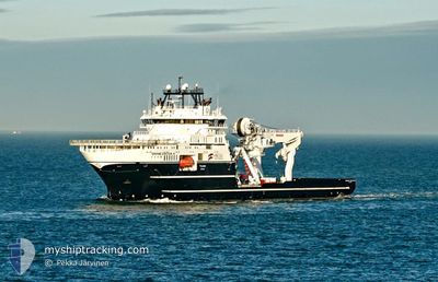
The vessel GRAND CANYON III (IMO: 9695963, MMSI: 257010590) is a Other Type It's sailing under the flag of [NO] Norway.
In this page you can find informations about the vessels current position, last detected port calls, and current voyage information. If the vessels is not in coverage by AIS you will find the latest position.
The current position of GRAND CANYON III is detected by our AIS receivers and we are not responsible for the reliability of the data. The last position was recorded while the vessel was in Coverage by the Ais receivers of our vessel tracking app.
The current draught of GRAND CANYON III as reported by AIS is 6.7 meters
Weather
| Temperature | 13.3°C / 55.94°F |
|---|---|
| Wind Speed | 4 knots |
| Direction | 14° NNE |
| Pressure | 1024.9 hPa |
| Humidity | 80 % |
| Cloud Coverage | 100 % |
Featured Company
Events
| Tid | Event | Detaljer | Position / Dest | Information |
|---|---|---|---|---|
| 2024-05-09 04:11 | Djupgående ändrat | 6.7 7 |
51.66025 / -5.26562
GREENLINK
|
Fart: 0.3 kn Kurs: 321° |
| 2024-05-09 03:27 | I täckningsområde |
51.66020 / -5.26570
Celtic Sea
GREENLINK
|
Fart: Kurs: 310.9° |
|
| 2024-05-09 00:59 | UTANFÖR täckningsområde |
51.76710 / -5.48763
Celtic Sea
GREENLINK
|
Fart: 12.8 kn Kurs: 146.1° |
|
| 2024-05-09 00:09 | Byter havsområde | United Kingdom part of the Celtic Sea United Kingdom part of the Irish Sea and St. George's Channel |
51.93695 / -5.55418
Celtic Sea
GREENLINK
|
Fart: 10.8 kn Kurs: 174.1° |
| 2024-05-08 22:38 | I täckningsområde |
52.20155 / -5.41648
Irish Sea and St. George's Channel
GREENLINK
|
Fart: 9.8 kn Kurs: 196° |
|
| 2024-05-08 21:14 | UTANFÖR täckningsområde |
52.40658 / -5.32323
Irish Sea and St. George's Channel
GREENLINK
|
Fart: 8.2 kn Kurs: 195.1° |
|
| 2024-05-08 21:14 | I täckningsområde |
52.40658 / -5.32323
Irish Sea and St. George's Channel
GREENLINK
|
Fart: 8.2 kn Kurs: 195.1° |
|
| 2024-05-08 17:47 | UTANFÖR täckningsområde |
52.85757 / -5.11957
Irish Sea and St. George's Channel
GREENLINK
|
Fart: 9.6 kn Kurs: 210° |
|
| 2024-05-08 14:23 | AVGÅTT HAMN |
|
53.32895 / -4.61515
GREENLINK
|
Fart: 5.8 kn Kurs: 35° |
| 2024-05-08 14:20 | STARTAR förflyttning |
53.32580 / -4.61922
[GB] HOLYHEAD
|
Fart: 3.1 kn Kurs: 28° |