
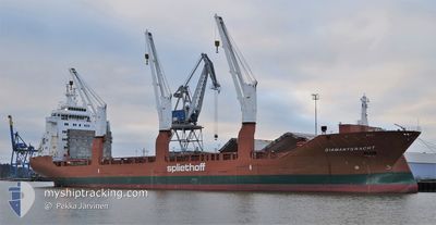
DIAMANTGRACHT
General Cargo
Current Trip
| Time Travelled | 13 days |
|---|---|
| Remaining Time | --- |
| Distance Travelled | 1878.10 nm |
| Remaining Distance | --- |
| AVG Speed | 10.9 Knop |
| MAX Speed | 15.4 Knop |
| AVG Wind | 7.9 knots |
| MAX Wind | 20 knots |
| MIN Temp | 25.7°C / 78.26°F |
| MAX Temp | 30.2°C / 86.36°F |
| Djupgående | 10.3 m |
| Position mottagen | 18 m sen |
Current Position
| Longitud | 116.59544° |
|---|---|
| Latitude | -20.57961° |
| Status | At anchor |
| Fart | |
| Kurs | 213° |
| Område | Indian Ocean |
| Station | T-AIS |
| Position mottagen | 18 m sen |
Info
Information
The current position of DIAMANTGRACHT is in Indian Ocean with coordinates -20.57961° / 116.59544° as reported on 2024-05-03 13:55 by AIS to our vessel tracker app. The vessel's current speed is 0 Knop
The vessel DIAMANTGRACHT (IMO: 9420813, MMSI: 244142000) is a General Cargo that was built in 2009 ( 15 År gammal ). It's sailing under the flag of [NL] Netherlands.
In this page you can find informations about the vessels current position, last detected port calls, and current voyage information. If the vessels is not in coverage by AIS you will find the latest position.
The current position of DIAMANTGRACHT is detected by our AIS receivers and we are not responsible for the reliability of the data. The last position was recorded while the vessel was in Coverage by the Ais receivers of our vessel tracking app.
The current draught of DIAMANTGRACHT as reported by AIS is 10.3 meters
Weather
| Temperature | 27°C / 80.6°F |
|---|---|
| Wind Speed | 2 knots |
| Direction | 37° NE |
| Pressure | 1015.8 hPa |
| Humidity | 59.3 % |
| Cloud Coverage | --- |
Featured Company
Most Visited Ports (Last year)
| Port | Arrivals | |
|---|---|---|
| 11 | ||
| 6 | ||
| 2 | ||
| 1 | ||
| 1 | ||
| 1 |
Events
| Tid | Event | Detaljer | Position / Dest | Information |
|---|---|---|---|---|
| 2024-05-03 14:01 | Status ändrad | Default At anchor |
-20.57951 / 116.59534
AU DAM
|
Fart: Kurs: 213° |
| 2024-05-03 13:52 | Status ändrad | At anchor Default |
-20.57963 / 116.59553
AU DAM
|
Fart: 0.1 kn Kurs: 218° |
| 2024-05-03 13:49 | Status ändrad | Default At anchor |
-20.57968 / 116.59558
AU DAM
|
Fart: 0.1 kn Kurs: 227° |
| 2024-05-03 13:43 | Status ändrad | At anchor Default |
-20.57977 / 116.59577
AU DAM
|
Fart: 0.1 kn Kurs: 238° |
| 2024-05-03 13:37 | Status ändrad | Default At anchor |
-20.57997 / 116.59588
AU DAM
|
Fart: Kurs: 245° |
| 2024-05-03 13:07 | Status ändrad | At anchor Default |
-20.58059 / 116.59611
AU DAM
|
Fart: Kurs: -1° |
| 2024-05-03 12:58 | Status ändrad | Default At anchor |
-20.58076 / 116.59611
AU DAM
|
Fart: Kurs: 276° |
| 2024-05-03 12:25 | Status ändrad | At anchor Default |
-20.58193 / 116.59561
AU DAM
|
Fart: 0.1 kn Kurs: 334° |
| 2024-05-03 12:13 | Status ändrad | Default At anchor |
-20.58167 / 116.59500
AU DAM
|
Fart: 0.1 kn Kurs: 349° |
| 2024-05-03 11:46 | Status ändrad | At anchor Default |
-20.58215 / 116.59510
AU DAM
|
Fart: Kurs: 356° |