
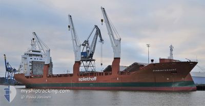
DIAMANTGRACHT
General Cargo
Current Trip
| Time Travelled | 6 days |
|---|---|
| Remaining Time | --- |
| Distance Travelled | 1433.26 nm |
| Remaining Distance | 471.25 nm |
| AVG Speed | 10.9 Knots |
| MAX Speed | 15.4 Knots |
| AVG Wind | 6.6 knots |
| MAX Wind | 17.9 knots |
| MIN Temp | 27.2°C / 80.96°F |
| MAX Temp | 30.2°C / 86.36°F |
| Draught | 10.3 m |
| Position Received | 4 d ago |
Current Position
| Longitude | 104.12201° |
|---|---|
| Latitude | 1.25320° |
| Status | Under way using engine |
| Speed | 11.6 Knots |
| Course | 83° |
| Area | Singapore Strait |
| Station | T-AIS |
| Position Received | 4 d ago |
Info
Information
The current position of DIAMANTGRACHT is in Singapore Strait with coordinates 1.25320° / 104.12201° as reported on 2024-04-21 01:55 by AIS to our vessel tracker app. The vessel's current speed is 11.6 Knots and is heading at the port of DAMPIER. The estimated time of arrival as calculated by MyShipTracking vessel tracking app is 2024-04-27 01:00 LT
The vessel DIAMANTGRACHT (IMO: 9420813, MMSI: 244142000) is a General Cargo that was built in 2009 ( 15 years old ). It's sailing under the flag of [NL] Netherlands.
In this page you can find informations about the vessels current position, last detected port calls, and current voyage information. If the vessels is not in coverage by AIS you will find the latest position.
The current position of DIAMANTGRACHT is detected by our AIS receivers and we are not responsible for the reliability of the data. The last position was recorded while the vessel was in Coverage by the Ais receivers of our vessel tracking app.
The current draught of DIAMANTGRACHT as reported by AIS is 10.3 meters
Weather
| Temperature | 29.4°C / 84.92°F |
|---|---|
| Wind Speed | 12 knots |
| Direction | 86° E |
| Pressure | 1010.4 hPa |
| Humidity | 68.4 % |
| Cloud Coverage | 100 % |
Featured Company
Most Visited Ports (Last year)
| Port | Arrivals | |
|---|---|---|
| 11 | ||
| 6 | ||
| 2 | ||
| 2 | ||
| 1 | ||
| 1 |
Events
| Time | Event | Details | Position / Dest | Info |
|---|---|---|---|---|
| 2024-04-21 02:00 | Status Changed | Default Under way using engine |
1.25501 / 104.13930
AU DAM
|
Speed: 11.6 kn Course: 83° |
| 2024-04-21 01:55 | OUT of Coverage |
1.25320 / 104.12201
Singapore Strait
AU DAM
|
Speed: 11.6 kn Course: 83° |
|
| 2024-04-21 01:26 | Destination Changed | AU DAM DAMPIER |
1.24070 / 104.02976
AU DAM
|
Speed: 11.4 kn Course: 89.3° |
| 2024-04-21 01:08 | Change Sea Area | Indonesian part of the Singapore Strait Singaporean part of the Singapore Strait |
1.24035 / 103.97746
Singapore Strait
DAMPIER
|
Speed: 10.5 kn Course: 100.7° |
| 2024-04-21 00:27 | START Moving | 2.52 nm, North East of SINGAPORE |
1.27626 / 103.89217
DAMPIER
|
Speed: 4.3 kn Course: 98° |
| 2024-04-21 00:20 | Status Changed | Under way using engine At anchor |
1.27593 / 103.88874
DAMPIER
|
Speed: 0.2 kn Course: 76° |
| 2024-04-20 20:38 | ETA Changed | 2024/04/27 01:00 2024/04/27 23:00 |
1.27731 / 103.89047
DAMPIER
|
Speed: Course: 230° |
| 2024-04-20 20:21 | Draught Changed | 10.3 10.2 |
1.27730 / 103.89040
DAMPIER
|
Speed: Course: 229° |
| 2024-04-20 20:14 | ETA Changed | 2024/04/27 23:00 2024/04/27 01:45 |
1.27736 / 103.89042
DAMPIER
|
Speed: Course: 226° |
| 2024-04-20 20:13 | Destination Changed | DAMPIER SINGAPORE |
1.27736 / 103.89042
DAMPIER
|
Speed: Course: 226° |