
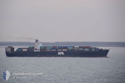
APL HOLLAND
Container Ship
Current Trip
| Time Travelled | 20 days |
|---|---|
| Remaining Time | --- |
| Distance Travelled | 5380.95 nm |
| Remaining Distance | --- |
| AVG Speed | 14.3 Knop |
| MAX Speed | 19.5 Knop |
| AVG Wind | 7.1 knots |
| MAX Wind | 19 knots |
| MIN Temp | 16.8°C / 62.24°F |
| MAX Temp | 30.5°C / 86.9°F |
| Djupgående | 8.9 m |
| Position mottagen | 2 d sen |
Current Position
| Longitud | 122.34485° |
|---|---|
| Latitude | 25.66530° |
| Status | Under way using engine |
| Fart | 15.9 Knop |
| Kurs | 3.2° |
| Område | Eastern China Sea |
| Station | T-AIS |
| Position mottagen | 2 d sen |
Info
Information
The current position of APL HOLLAND is in Eastern China Sea with coordinates 25.66530° / 122.34485° as reported on 2024-04-26 01:49 by AIS to our vessel tracker app. The vessel's current speed is 15.9 Knop
The vessel APL HOLLAND (IMO: 9218674, MMSI: 563754000) is a Container Ship that was built in 2001 ( 23 År gammal ). It's sailing under the flag of [SG] Singapore.
In this page you can find informations about the vessels current position, last detected port calls, and current voyage information. If the vessels is not in coverage by AIS you will find the latest position.
The current position of APL HOLLAND is detected by our AIS receivers and we are not responsible for the reliability of the data. The last position was recorded while the vessel was in Coverage by the Ais receivers of our vessel tracking app.
The current draught of APL HOLLAND as reported by AIS is 8.9 meters
Weather
| Temperature | 17.8°C / 64.04°F |
|---|---|
| Wind Speed | 11 knots |
| Direction | 131° SE |
| Pressure | 1010.2 hPa |
| Humidity | 99.8 % |
| Cloud Coverage | 100 % |
Featured Company
Last Port Calls
| Port | Arrival | Departure | Time In Port |
|---|---|---|---|
| 2024-04-07 01:23 | 2024-04-07 16:31 | 15 h | |
| 2024-04-03 18:49 | 2024-04-04 16:09 | 21 h | |
| 2024-03-25 18:06 | 2024-03-26 16:07 | 22 h | |
| 2024-03-10 07:44 | 2024-03-10 22:07 | 14 h | |
| 2024-03-03 09:30 | 2024-03-03 20:16 | 10 h | |
| 2024-02-21 08:00 | 2024-02-22 10:11 | 1 d | |
| 2024-02-14 14:35 | 2024-02-15 06:35 | 16 h |
Last Trips
| Origin | Departure | Destination | Arrival | Distance | |
|---|---|---|---|---|---|
| 2024-04-04 20:09 | 2024-04-07 05:23 | 13.61 nm | |||
| 2024-03-27 00:07 | 2024-04-03 22:49 | 3235.71 nm | |||
| 2024-03-11 06:07 | 2024-03-26 02:06 | 1479.06 nm | |||
| 2024-03-04 04:16 | 2024-03-10 15:44 | 1284.27 nm | |||
| 2024-02-22 18:11 | 2024-03-03 17:30 | 2588.72 nm | |||
| 2024-02-15 12:05 | 2024-02-21 16:00 | 1769.92 nm | |||
| 2024-01-24 09:08 | 2024-02-14 20:05 | 6971.85 nm |
Events
| Tid | Event | Detaljer | Position / Dest | Information |
|---|---|---|---|---|
| 2024-04-27 03:02 | STOPPAR förflyttning |
29.70507 / 122.90710
CNNGB
|
Fart: 0.2 kn Kurs: 149° |
|
| 2024-04-26 11:02 | STARTAR förflyttning |
26.60485 / 122.53581
CNNGB
|
Fart: 9.5 kn Kurs: 7° |
|
| 2024-04-26 09:03 | STOPPAR förflyttning |
26.59097 / 122.56168
CNNGB
|
Fart: 0.3 kn Kurs: 353° |
|
| 2024-04-26 01:53 | Status ändrad | Default Under way using engine |
25.68114 / 122.34600
CNNGB
|
Fart: 15.9 kn Kurs: 3.2° |
| 2024-04-26 01:49 | Status ändrad | Under way using engine Default |
25.66530 / 122.34485
CNNGB
|
Fart: 15.5 kn Kurs: 7° |
| 2024-04-26 01:49 | UTANFÖR täckningsområde |
25.66530 / 122.34485
Eastern China Sea
CNNGB
|
Fart: 15.9 kn Kurs: 3.2° |
|
| 2024-04-26 01:34 | Status ändrad | Default Under way using engine |
25.59605 / 122.33896
CNNGB
|
Fart: 15.8 kn Kurs: 4.5° |
| 2024-04-25 23:53 | Destination ändrad | CNNGB CNSHK |
25.17286 / 122.28452
CNNGB
|
Fart: 15.7 kn Kurs: 9.3° |
| 2024-04-25 23:53 | ETA ändrat | 2024/04/26 22:00 2024/04/21 10:00 |
25.17286 / 122.28452
CNNGB
|
Fart: 15.7 kn Kurs: 9.3° |
| 2024-04-25 23:04 | Byter havsområde | Taiwanese part of the Eastern China Sea Taiwanese part of the Philippine Sea |
24.96913 / 122.22225
Eastern China Sea
|
Fart: 14.4 kn Kurs: 20.5° |