
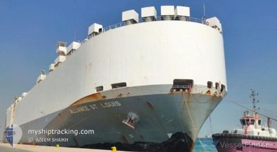
ALLIANCE ST.LOUIS
Vehicles Carrier
Current Trip
| Time Travelled | 3 days |
|---|---|
| Remaining Time | --- |
| Distance Travelled | 1245.69 nm |
| Remaining Distance | --- |
| AVG Speed | 16 Knop |
| MAX Speed | 20.7 Knop |
| AVG Wind | 10.4 knots |
| MAX Wind | 28.8 knots |
| MIN Temp | 16.1°C / 60.98°F |
| MAX Temp | 24.7°C / 76.46°F |
| Djupgående | 8.7 m |
| Position mottagen | 1 d sen |
Current Position
| Longitud | 17.95507° |
|---|---|
| Latitude | -34.42352° |
| Status | Under way using engine |
| Fart | 15.3 Knop |
| Kurs | 287° |
| Område | South Atlantic Ocean |
| Station | T-AIS |
| Position mottagen | 1 d sen |
Info
Information
The current position of ALLIANCE ST.LOUIS is in South Atlantic Ocean with coordinates -34.42352° / 17.95507° as reported on 2024-05-16 19:03 by AIS to our vessel tracker app. The vessel's current speed is 15.3 Knop and is heading at the port of KINGSTON (JM). The estimated time of arrival as calculated by MyShipTracking vessel tracking app is 2024-06-02 10:00 LT
The vessel ALLIANCE ST.LOUIS (IMO: 9285500, MMSI: 367093000) is a Vehicles Carrier that was built in 2005 ( 19 År gammal ). It's sailing under the flag of [US] USA.
In this page you can find informations about the vessels current position, last detected port calls, and current voyage information. If the vessels is not in coverage by AIS you will find the latest position.
The current position of ALLIANCE ST.LOUIS is detected by our AIS receivers and we are not responsible for the reliability of the data. The last position was recorded while the vessel was in Coverage by the Ais receivers of our vessel tracking app.
The current draught of ALLIANCE ST.LOUIS as reported by AIS is 8.7 meters
Weather
| Temperature | 18.3°C / 64.94°F |
|---|---|
| Wind Speed | 4 knots |
| Direction | 242° WSW |
| Pressure | 1022.1 hPa |
| Humidity | 77.2 % |
| Cloud Coverage | 100 % |
Featured Company
Last Port Calls
| Port | Arrival | Departure | Time In Port |
|---|---|---|---|
| 2024-05-13 00:44 | 2024-05-14 18:28 | 1 d | |
| 2024-04-30 21:00 | 2024-05-02 12:21 | 1 d | |
| 2024-04-29 20:34 | 2024-04-30 09:01 | 12 h | |
| 2024-04-24 16:58 | 2024-04-25 11:50 | 18 h | |
| 2024-04-23 17:12 | 2024-04-24 07:51 | 14 h | |
| 2024-04-22 10:29 | 2024-04-22 17:57 | 7 h | |
| 2024-04-19 01:44 | 2024-04-21 03:51 | 2 d | |
| 2024-03-04 01:15 |
Most Visited Ports (Last year)
| Port | Arrivals | |
|---|---|---|
| 5 | ||
| 4 | ||
| 4 | ||
| 3 | ||
| 3 | ||
| 3 |
Last Trips
| Origin | Departure | Destination | Arrival | Distance | |
|---|---|---|---|---|---|
| 2024-05-02 17:51 | 2024-05-13 02:44 | 3908.48 nm | |||
| 2024-04-30 14:31 | 2024-05-01 02:30 | 176.78 nm | |||
| 2024-04-25 14:50 | 2024-04-30 02:04 | 1520.04 nm | |||
| 2024-04-24 10:51 | 2024-04-24 19:58 | 51.09 nm | |||
| 2024-04-22 20:57 | 2024-04-23 20:12 | 298.03 nm | |||
| 2024-04-21 07:51 | 2024-04-22 13:29 | 376.18 nm | |||
| 2024-02-17 03:28 | 2024-03-03 19:15 | 5029.68 nm |
Events
| Tid | Event | Detaljer | Position / Dest | Information |
|---|---|---|---|---|
| 2024-05-16 19:10 | Status ändrad | Default Under way using engine |
-34.41538 / 17.92345
JMKIN
|
Fart: 15.3 kn Kurs: 287° |
| 2024-05-16 19:03 | UTANFÖR täckningsområde |
-34.42352 / 17.95507
South Atlantic Ocean
JMKIN
|
Fart: 15.3 kn Kurs: 287° |
|
| 2024-05-16 18:56 | Status ändrad | Under way using engine Default |
-34.43427 / 17.99325
JMKIN
|
Fart: 15.5 kn Kurs: 289° |
| 2024-05-16 18:50 | Status ändrad | Default Under way using engine |
-34.44237 / 18.02155
JMKIN
|
Fart: 15.4 kn Kurs: 289° |
| 2024-05-16 16:27 | Status ändrad | Under way using engine Default |
-34.67703 / 18.70683
JMKIN
|
Fart: 15.2 kn Kurs: 292° |
| 2024-05-16 15:43 | Status ändrad | Default Under way using engine |
-34.72500 / 18.91667
JMKIN
|
Fart: 14.9 kn Kurs: 275° |
| 2024-05-16 15:13 | Byter havsområde | South African part of the South Atlantic Ocean South African part of the Indian Ocean |
-34.74445 / 19.06388
South Atlantic Ocean
JMKIN
|
Fart: 14.2 kn Kurs: 287° |
| 2024-05-16 15:12 | Status ändrad | Under way using engine Default |
-34.74545 / 19.06792
JMKIN
|
Fart: 13.8 kn Kurs: 287° |
| 2024-05-16 14:55 | I täckningsområde |
-34.74445 / 19.06388
South Atlantic Ocean
JMKIN
|
Fart: 14.2 kn Kurs: 287° |
|
| 2024-05-14 18:58 | UTANFÖR täckningsområde |
-29.91267 / 31.12607
Indian Ocean
JMKIN
|
Fart: 14.4 kn Kurs: 188° |