
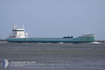
MARIETJE MARSILLA
General Cargo
Current Trip
| Time Travelled | 1 day |
|---|---|
| Remaining Time | --- |
| Distance Travelled | 464.12 морская миля |
| Remaining Distance | --- |
| AVG Speed | 11.4 Узлы |
| MAX Speed | 15.5 Узлы |
| AVG Wind | 10 knots |
| MAX Wind | 24.2 knots |
| MIN Temp | 10.7°C / 51.26°F |
| MAX Temp | 16.8°C / 62.24°F |
| Осадка | 6.6 м |
| Позиция Получена | 9 h, 0 m тому назад |
Current Position
| Долгота | -4.65219° |
|---|---|
| Широта | 58.68676° |
| Статус | Under way using engine |
| Скорость | 12 Узлы |
| Курс | 268.1° |
| Район | North Atlantic Ocean |
| Станция | T-AIS |
| Позиция Получена | 9 h, 0 m тому назад |
Info
Information
The current position of MARIETJE MARSILLA is in North Atlantic Ocean with coordinates 58.68676° / -4.65219° as reported on 2024-07-26 19:39 by AIS to our vessel tracker app. The vessel's current speed is 12 Узлы and is heading at the port of NEW ORLEANS. The estimated time of arrival as calculated by MyShipTracking vessel tracking app is 2024-08-11 12:00 LT
The vessel MARIETJE MARSILLA (IMO: 9458248, MMSI: 246754000) is a General Cargo that was built in 2010 ( 14 лет ). It's sailing under the flag of [NL] Netherlands.
In this page you can find informations about the vessels current position, last detected port calls, and current voyage information. If the vessels is not in coverage by AIS you will find the latest position.
The current position of MARIETJE MARSILLA is detected by our AIS receivers and we are not responsible for the reliability of the data. The last position was recorded while the vessel was in Coverage by the Ais receivers of our vessel tracking app.
The current draught of MARIETJE MARSILLA as reported by AIS is 6.6 meters
Weather
| Temperature | 13.2°C / 55.76°F |
|---|---|
| Wind Speed | 8 knots |
| Direction | 207° SSW |
| Pressure | 1007.3 hPa |
| Humidity | 85 % |
| Cloud Coverage | 23 % |
Featured Company
Last Port Calls
| Port | Arrival | Departure | Time In Port |
|---|---|---|---|
| 2024-07-22 20:41 | 2024-07-25 13:41 | 2 d | |
| 2024-07-18 06:22 | 2024-07-18 17:25 | 11 h | |
| 2024-07-12 18:34 | 2024-07-14 08:22 | 1 d | |
| 2024-07-09 10:38 | 2024-07-09 19:52 | 9 h | |
| 2024-07-07 01:07 | 2024-07-07 22:18 | 21 h | |
| 2024-07-02 22:06 | 2024-07-04 12:53 | 1 d | |
| 2024-06-29 23:47 | 2024-07-01 00:00 | 1 d | |
| 2024-06-21 11:28 | 2024-06-24 12:39 | 3 d | |
| 2024-06-16 13:24 | 2024-06-18 12:14 | 1 d | |
| 2024-06-05 07:49 | 2024-06-07 17:44 | 2 d |
Most Visited Ports (Last year)
| Port | Arrivals | |
|---|---|---|
| 12 | ||
| 8 | ||
| 4 | ||
| 3 | ||
| 2 | ||
| 2 |
Last Trips
| Origin | Departure | Destination | Arrival | Distance | |
|---|---|---|---|---|---|
| 2024-07-18 17:25 | 2024-07-22 20:41 | 309.43 морская миля | |||
| 2024-07-14 08:22 | 2024-07-18 06:22 | 452.08 морская миля | |||
| 2024-07-09 19:52 | 2024-07-12 18:34 | 656.60 морская миля | |||
| 2024-07-07 22:18 | 2024-07-09 10:38 | 442.47 морская миля | |||
| 2024-07-04 12:53 | 2024-07-07 01:07 | 530.13 морская миля | |||
| 2024-07-01 00:00 | 2024-07-02 22:06 | 532.78 морская миля | |||
| 2024-06-24 12:39 | 2024-06-29 23:47 | 532.33 морская миля | |||
| 2024-06-18 12:14 | 2024-06-21 11:28 | 650.82 морская миля | |||
| 2024-06-07 17:44 | 2024-06-16 13:24 | 575.93 морская миля | |||
| 2024-05-29 21:47 | 2024-06-05 07:49 | 808.35 морская миля |
Events
| Время | Событие | Детали | Позиция / Направление | Информация |
|---|---|---|---|---|
| 2024-07-26 19:39 | Вне покрытия |
58.68676 / -4.65219
North Atlantic Ocean
USMSY
|
Скорость: 12 kn Курс: 268.1° |
|
| 2024-07-26 16:59 | Изменение морского района | United Kingdom part of the North Atlantic Ocean United Kingdom part of the North Sea |
58.70678 / -3.58871
North Atlantic Ocean
USMSY
|
Скорость: 13.5 kn Курс: 267.8° |
| 2024-07-26 16:56 | Статус изменился | Under way using engine Default |
58.70707 / -3.57283
USMSY
|
Скорость: 13.6 kn Курс: 267° |
| 2024-07-26 16:41 | Статус изменился | Default Under way using engine |
58.71019 / -3.46162
USMSY
|
Скорость: 13.6 kn Курс: 269.7° |
| 2024-07-26 16:25 | Статус изменился | Under way using engine Default |
58.71152 / -3.34121
USMSY
|
Скорость: 14.2 kn Курс: 269° |
| 2024-07-26 16:09 | Статус изменился | Default Under way using engine |
58.71489 / -3.22137
USMSY
|
Скорость: 13.9 kn Курс: 265.7° |
| 2024-07-26 14:40 | Обнаружено в море | United Kingdom part of the North Sea |
58.72415 / -2.66369
North Sea
USMSY
|
Скорость: 8.9 kn Курс: 264.7° |
| 2024-07-26 14:39 | Статус изменился | Under way using engine Default |
58.72461 / -2.65494
USMSY
|
Скорость: 8.9 kn Курс: 264° |
| 2024-07-26 14:21 | В покрытии |
58.72415 / -2.66369
North Sea
USMSY
|
Скорость: 8.9 kn Курс: 264.7° |
|
| 2024-07-25 22:05 | Вне покрытия |
59.00175 / 2.91818
North Sea
USMSY
|
Скорость: 11 kn Курс: 262.6° |