
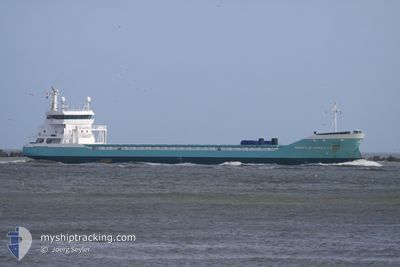
MARIETJE MARSILLA
General Cargo
Current Trip
| Trip Time | 1 day |
|---|---|
| Trip Distance | 533.71 nm |
| AVG Speed | 11 Knots |
| MAX Speed | 14.6 Knots |
| Draught | 7 m |
| AVG Wind | 16.8 knots |
| MAX Wind | 26.5 knots |
| MIN Temp | 5.3°C / 41.54°F |
| MAX Temp | 7.7°C / 45.86°F |
| Position Received | 3 m ago |
Current Position
| Longitude | 9.61647° |
|---|---|
| Latitude | 59.12590° |
| Status | Moored |
| Speed | |
| Course | 43° |
| Area | Skaggerak |
| Station | T-AIS |
| Position Received | 3 m ago |
Info
Information
The current position of MARIETJE MARSILLA is in Skaggerak with coordinates 59.12590° / 9.61647° as reported on 2024-04-24 19:04 by AIS to our vessel tracker app. The vessel's current speed is 0 Knots and is currently inside the port of PORSGRUNN.
The vessel MARIETJE MARSILLA (IMO: 9458248, MMSI: 246754000) is a General Cargo that was built in 2010 ( 14 years old ). It's sailing under the flag of [NL] Netherlands.
In this page you can find informations about the vessels current position, last detected port calls, and current voyage information. If the vessels is not in coverage by AIS you will find the latest position.
The current position of MARIETJE MARSILLA is detected by our AIS receivers and we are not responsible for the reliability of the data. The last position was recorded while the vessel was in Coverage by the Ais receivers of our vessel tracking app.
The current draught of MARIETJE MARSILLA as reported by AIS is 7 meters
Weather
| Temperature | 3.7°C / 38.66°F |
|---|---|
| Wind Speed | 1 knots |
| Direction | 278° W |
| Pressure | 1006.6 hPa |
| Humidity | 78.4 % |
| Cloud Coverage | 100 % |
Featured Company
Last Port Calls
| Port | Arrival | Departure | Time In Port |
|---|---|---|---|
| 2024-04-24 16:51 | |||
| 2024-04-20 12:15 | 2024-04-22 20:13 | 2 d | |
| 2024-04-17 01:02 | 2024-04-18 01:03 | 1 d | |
| 2024-04-13 10:36 | 2024-04-15 07:56 | 1 d | |
| 2024-04-05 18:56 | 2024-04-08 23:58 | 3 d | |
| 2024-04-01 16:42 | 2024-04-03 10:03 | 1 d | |
| 2024-03-22 16:10 | 2024-03-26 11:27 | 3 d | |
| 2024-03-18 10:40 | 2024-03-20 07:06 | 1 d | |
| 2024-03-08 14:41 | 2024-03-13 16:52 | 5 d | |
| 2024-03-05 08:20 | 2024-03-08 10:39 | 3 d |
Last Trips
| Origin | Departure | Destination | Arrival | Distance | |
|---|---|---|---|---|---|
| 2024-04-22 22:13 | 2024-04-24 18:51 | 533.71 nm | |||
| 2024-04-18 03:03 | 2024-04-20 14:15 | 576.12 nm | |||
| 2024-04-15 09:56 | 2024-04-17 03:02 | 4.11 nm | |||
| 2024-04-09 01:58 | 2024-04-13 12:36 | 550.80 nm | |||
| 2024-04-03 12:03 | 2024-04-05 20:56 | 533.94 nm | |||
| 2024-03-26 12:27 | 2024-04-01 18:42 | 533.82 nm | |||
| 2024-03-20 08:06 | 2024-03-22 17:10 | 531.75 nm | |||
| 2024-03-13 17:52 | 2024-03-18 11:40 | 533.32 nm | |||
| 2024-03-08 11:39 | 2024-03-08 15:41 | 31.33 nm | |||
| 2024-03-04 03:40 | 2024-03-05 09:20 | 344.99 nm |
Events
| Time | Event | Details | Position / Dest | Info |
|---|---|---|---|---|
| 2024-04-24 17:08 | Status Changed | Moored Under way using engine |
59.12594 / 9.61650
[NO] PORSGRUNN
|
Speed: Course: 44° |
| 2024-04-24 17:04 | STOP Moving |
59.12597 / 9.61632
[NO] PORSGRUNN
|
Speed: 0.3 kn Course: 51° |
|
| 2024-04-24 16:51 | PORT ARRIVAL |
|
59.12259 / 9.60733
[NO] PORSGRUNN
|
Speed: 4.7 kn Course: 41° |
| 2024-04-24 08:35 | Detected in Sea | Norwegian part of the Skaggerak |
57.67928 / 8.79129
Skaggerak
NOHRY
|
Speed: 12.9 kn Course: 30.6° |
| 2024-04-24 06:20 | Change Sea Area | Danish part of the Skaggerak Danish part of the North Sea |
57.28898 / 8.31914
Skaggerak
NOHRY
|
Speed: 11.9 kn Course: 32.9° |
| 2024-04-23 23:35 | Change Sea Area | Danish part of the North Sea Dutch part of the North Sea |
56.16667 / 7.31159
North Sea
NOHRY
|
Speed: 10.4 kn Course: 22.4° |
| 2024-04-23 23:35 | Status Changed | Under way using engine Default |
56.16667 / 7.31159
NOHRY
|
Speed: 10 kn Course: 28° |
| 2024-04-23 23:21 | IN Coverage |
56.16667 / 7.31159
North Sea
NOHRY
|
Speed: 10.4 kn Course: 22.4° |
|
| 2024-04-23 04:05 | Status Changed | Default Under way using engine |
52.79518 / 4.17379
NOHRY
|
Speed: 13.9 kn Course: 34.4° |
| 2024-04-23 03:58 | OUT of Coverage |
52.77215 / 4.14797
North Sea
NOHRY
|
Speed: 13.9 kn Course: 34.4° |