
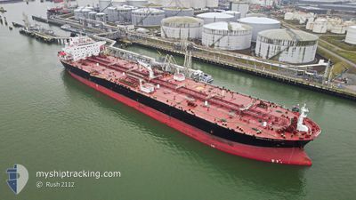
WHISTLER SPIRIT
Crude Oil Tanker
Current Trip
US SABINE LZ
| Time Travelled | 7 days |
|---|---|
| Remaining Time | --- |
| Distance Travelled | 642.37 nm |
| Remaining Distance | --- |
| AVG Speed | 11.5 Knopen |
| MAX Speed | 15.9 Knopen |
| AVG Wind | 14.2 knots |
| MAX Wind | 24.5 knots |
| MIN Temp | 18.3°C / 64.94°F |
| MAX Temp | 27.6°C / 81.68°F |
| Diepgang | 11.8 M |
| Positie ontvangen | 1 d geleden |
Current Position
| Lengtegraad | -94.49652° |
|---|---|
| Breedtegraat | 28.60528° |
| Status | At anchor |
| Snelheid | |
| Koers | 171° |
| Gebied | Gulf of Mexico |
| Station | T-AIS |
| Positie ontvangen | 1 d geleden |
Info
Information
The current position of WHISTLER SPIRIT is in Gulf of Mexico with coordinates 28.60528° / -94.49652° as reported on 2024-05-02 14:49 by AIS to our vessel tracker app. The vessel's current speed is 0 Knopen
The vessel WHISTLER SPIRIT (IMO: 9417323, MMSI: 311000224) is a Crude Oil Tanker that was built in 2010 ( 14 Jaar oud ). It's sailing under the flag of [BS] Bahamas.
In this page you can find informations about the vessels current position, last detected port calls, and current voyage information. If the vessels is not in coverage by AIS you will find the latest position.
The current position of WHISTLER SPIRIT is detected by our AIS receivers and we are not responsible for the reliability of the data. The last position was recorded while the vessel was in Coverage by the Ais receivers of our vessel tracking app.
The current draught of WHISTLER SPIRIT as reported by AIS is 11.8 meters
Weather
| Temperature | 23.8°C / 74.84°F |
|---|---|
| Wind Speed | 17 knots |
| Direction | 114° ESE |
| Pressure | 1011 hPa |
| Humidity | 91.2 % |
| Cloud Coverage | --- |
Featured Company
Last Port Calls
| Port | Arrival | Departure | Time In Port |
|---|---|---|---|
| 2024-04-24 23:06 | 2024-04-26 07:22 | 1 d | |
| 2024-04-20 18:50 | 2024-04-20 19:34 | 44 m | |
| 2024-04-07 16:55 | 2024-04-08 21:07 | 1 d | |
| 2024-04-01 01:34 | 2024-04-04 17:46 | 3 d | |
| 2024-03-03 20:42 | 2024-03-06 03:52 | 2 d |
Most Visited Ports (Last year)
| Port | Arrivals | |
|---|---|---|
| 10 | ||
| 6 | ||
| 5 | ||
| 4 | ||
| 3 | ||
| 3 |
Last Trips
| Origin | Departure | Destination | Arrival | Distance | |
|---|---|---|---|---|---|
| 2024-04-20 14:34 | 2024-04-24 18:06 | 622.56 nm | |||
| 2024-04-08 16:07 | 2024-04-20 13:50 | 830.14 nm | |||
| 2024-04-04 11:46 | 2024-04-07 11:55 | 895.56 nm | |||
| 2024-03-05 21:52 | 2024-03-31 19:34 | 851.83 nm | |||
| 2024-02-17 17:27 | 2024-03-03 14:42 | 1360.71 nm |
Events
| Tijd | Evenement | Details | Positie / Bestemming | Info |
|---|---|---|---|---|
| 2024-05-02 21:12 | Stop beweging |
28.62333 / -94.63666
US SABINE LZ
|
Snelheid: Koers: -1° |
|
| 2024-05-02 19:09 | Start beweging |
28.64833 / -94.47667
US SABINE LZ
|
Snelheid: 4 kn Koers: -1° |
|
| 2024-05-02 14:55 | Status Changed | Default At anchor |
28.60523 / -94.49655
US SABINE LZ
|
Snelheid: Koers: 171° |
| 2024-05-02 14:49 | Buitenbereik |
28.60528 / -94.49652
Gulf of Mexico
|
Snelheid: Koers: 277.7° |
|
| 2024-05-02 14:43 | Status Changed | At anchor Default |
28.60527 / -94.49658
US SABINE LZ
|
Snelheid: 0.1 kn Koers: 168° |
| 2024-05-02 13:53 | Status Changed | Default At anchor |
28.60535 / -94.49651
US SABINE LZ
|
Snelheid: Koers: 173° |
| 2024-05-02 13:46 | Status Changed | At anchor Default |
28.60531 / -94.49638
US SABINE LZ
|
Snelheid: 0.1 kn Koers: 162° |
| 2024-05-02 13:34 | Binnenbereik |
28.60531 / -94.49638
Gulf of Mexico
|
Snelheid: Koers: 277.7° |
|
| 2024-05-01 12:12 | Status Changed | Default Under way using engine |
28.60333 / -94.49500
US SABINE LZ
|
Snelheid: 0.8 kn Koers: 149° |
| 2024-05-01 12:08 | Buitenbereik |
28.60430 / -94.49601
Gulf of Mexico
|
Snelheid: 0.8 kn Koers: 201.4° |