
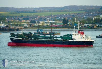
SWALINGE
Hopper Dredger
Current Trip
GBTEE
| Time Travelled | 8 h, 48 mins |
|---|---|
| Remaining Time | --- |
| Distance Travelled | 91.55 nm |
| Remaining Distance | --- |
| AVG Speed | 10.3 Knopen |
| MAX Speed | 12.6 Knopen |
| AVG Wind | 17.4 knots |
| MAX Wind | 21 knots |
| MIN Temp | 5.2°C / 41.36°F |
| MAX Temp | 7.6°C / 45.68°F |
| Diepgang | 6.3 M |
| Positie ontvangen | 48 m geleden |
Current Position
| Lengtegraad | --- |
|---|---|
| Breedtegraat | --- |
| Status | Under way using engine |
| Snelheid | 9.6 Knopen |
| Koers | 143° |
| Gebied | North Sea |
| Station | T-AIS |
| Positie ontvangen | 48 m geleden |
Info
Information
The current position of SWALINGE is in North Sea with coordinates 53.67529° / 0.43857° as reported on 2025-12-05 11:25 by AIS to our vessel tracker app. The vessel's current speed is 9.6 Knopen
The vessel SWALINGE (IMO: 7637448, MMSI: 244209000) is a Hopper Dredger that was built in 1977 ( 48 Jaar oud ). It's sailing under the flag of [NL] Netherlands.
In this page you can find informations about the vessels current position, last detected port calls, and current voyage information. If the vessels is not in coverage by AIS you will find the latest position.
The current position of SWALINGE is detected by our AIS receivers and we are not responsible for the reliability of the data. The last position was recorded while the vessel was in Coverage by the Ais receivers of our vessel tracking app.
The current draught of SWALINGE as reported by AIS is 6.3 meters
Weather
| Temperature | 6.9°C / 44.42°F |
|---|---|
| Wind Speed | 20 knots |
| Direction | 179° S |
| Pressure | 1004.9 hPa |
| Humidity | 78.5 % |
| Cloud Coverage | 72 % |
Featured Company
Last Port Calls
| Port | Arrival | Departure | Time In Port |
|---|---|---|---|
| 2025-12-04 22:42 | 2025-12-05 03:26 | 4 h | |
| 2025-12-03 13:20 | 2025-12-03 15:10 | 1 h | |
| 2025-12-03 09:00 | 2025-12-03 09:18 | 17 m | |
| 2025-12-03 05:56 | 2025-12-03 08:27 | 2 h | |
| 2025-11-30 21:47 | 2025-12-01 00:10 | 2 h | |
| 2025-11-29 13:41 | 2025-11-29 17:54 | 4 h | |
| 2025-11-29 00:43 | 2025-11-29 08:52 | 8 h | |
| 2025-11-28 17:33 | 2025-11-28 19:43 | 2 h | |
| 2025-11-28 13:33 | 2025-11-28 13:48 | 15 m | |
| 2025-11-28 10:44 | 2025-11-28 12:40 | 1 h |
Last Trips
| Origin | Departure | Destination | Arrival | Distance | |
|---|---|---|---|---|---|
| 2025-12-03 16:10 | 2025-12-04 22:42 | 262.91 nm | |||
| 2025-12-03 10:18 | 2025-12-03 14:20 | 1.86 nm | |||
| 2025-12-03 09:27 | 2025-12-03 10:00 | 1.18 nm | |||
| 2025-12-01 01:10 | 2025-12-03 06:56 | 418.36 nm | |||
| 2025-11-29 18:54 | 2025-11-30 22:47 | 5.75 nm | |||
| 2025-11-29 09:52 | 2025-11-29 14:41 | 35.45 nm | |||
| 2025-11-28 20:43 | 2025-11-29 01:43 | 35.98 nm | |||
| 2025-11-28 14:48 | 2025-11-28 18:33 | 2.70 nm | |||
| 2025-11-28 13:40 | 2025-11-28 14:33 | 2.46 nm | |||
| 2025-11-28 07:14 | 2025-11-28 11:44 | 33.27 nm |
Events
| Tijd | Evenement | Details | Positie / Bestemming | Info |
|---|---|---|---|---|
| 2025-12-05 11:27 | Status Changed | Default Under way using engine |
53.67099 / .44369
GBTEE
|
Snelheid: 9.6 kn Koers: 143° |
| 2025-12-05 11:21 | Status Changed | Under way using engine Default |
53.68249 / .42983
GBTEE
|
Snelheid: 9.6 kn Koers: 144° |
| 2025-12-05 10:29 | Status Changed | Default Under way using engine |
53.80167 / .30442
GBTEE
|
Snelheid: 9.6 kn Koers: 149° |
| 2025-12-05 07:33 | Status Changed | Under way using engine Default |
54.18833 / -.10063
GBTEE
|
Snelheid: 10.5 kn Koers: 139° |
| 2025-12-05 07:23 | Binnenbereik |
54.18833 / -.10063
North Sea
|
Snelheid: 10.4 kn Koers: 139° |
|
| 2025-12-05 06:22 | Status Changed | Default Under way using engine |
54.34965 / -.34029
GBTEE
|
Snelheid: 11.2 kn Koers: 141° |
| 2025-12-05 06:17 | Buitenbereik |
54.36248 / -.35730
North Sea
|
Snelheid: 11.2 kn Koers: 141° |
|
| 2025-12-05 05:28 | Status Changed | Under way using engine Default |
54.48691 / -.52349
GBTEE
|
Snelheid: 12.2 kn Koers: 140° |
| 2025-12-05 05:26 | Status Changed | Default Under way using engine |
54.49163 / -.53031
GBTEE
|
Snelheid: 12.3 kn Koers: 136° |
| 2025-12-05 05:13 | Status Changed | Under way using engine Default |
54.52402 / -.58604
GBTEE
|
Snelheid: 12.4 kn Koers: 120° |