
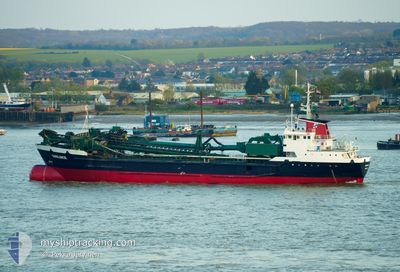
SWALINGE
Hopper Dredger
Current Trip
DREDGE AREA
| Time Travelled | 1 day |
|---|---|
| Remaining Time | --- |
| Distance Travelled | 7.69 nm |
| Remaining Distance | --- |
| AVG Speed | 6.9 Knots |
| MAX Speed | 9.2 Knots |
| AVG Wind | 23.1 knots |
| MAX Wind | 36 knots |
| MIN Temp | 9.3°C / 48.74°F |
| MAX Temp | 12.6°C / 54.68°F |
| Draught | 6.3 m |
| Position Received | 2 m ago |
Current Position
| Longitude | --- |
|---|---|
| Latitude | --- |
| Status | At anchor |
| Speed | 0.2 Knots |
| Course | 255° |
| Area | North Sea |
| Station | T-AIS |
| Position Received | 2 m ago |
Info
Information
The current position of SWALINGE is in North Sea with coordinates 51.44404° / 3.13213° as reported on 2025-12-07 19:44 by AIS to our vessel tracker app. The vessel's current speed is 0.2 Knots
The vessel SWALINGE (IMO: 7637448, MMSI: 244209000) is a Hopper Dredger that was built in 1977 ( 48 years old ). It's sailing under the flag of [NL] Netherlands.
In this page you can find informations about the vessels current position, last detected port calls, and current voyage information. If the vessels is not in coverage by AIS you will find the latest position.
The current position of SWALINGE is detected by our AIS receivers and we are not responsible for the reliability of the data. The last position was recorded while the vessel was in Coverage by the Ais receivers of our vessel tracking app.
The current draught of SWALINGE as reported by AIS is 6.3 meters
Weather
| Temperature | 12.6°C / 54.68°F |
|---|---|
| Wind Speed | 36 knots |
| Direction | 241° WSW |
| Pressure | 1001.5 hPa |
| Humidity | 85.7 % |
| Cloud Coverage | 100 % |
Featured Company
Last Port Calls
| Port | Arrival | Departure | Time In Port |
|---|---|---|---|
| 2025-12-06 19:23 | 2025-12-06 20:36 | 1 h | |
| 2025-12-06 18:06 | 2025-12-06 18:22 | 15 m | |
| 2025-12-06 11:24 | 2025-12-06 13:21 | 1 h | |
| 2025-12-04 22:42 | 2025-12-05 03:26 | 4 h | |
| 2025-12-03 14:20 | 2025-12-03 16:10 | 1 h | |
| 2025-12-03 10:00 | 2025-12-03 10:18 | 17 m | |
| 2025-12-03 06:56 | 2025-12-03 09:27 | 2 h | |
| 2025-11-30 22:47 | 2025-12-01 01:10 | 2 h | |
| 2025-11-29 14:41 | 2025-11-29 18:54 | 4 h | |
| 2025-11-29 01:43 | 2025-11-29 09:52 | 8 h |
Last Trips
| Origin | Departure | Destination | Arrival | Distance | |
|---|---|---|---|---|---|
| 2025-12-06 18:22 | 2025-12-06 19:23 | 5.98 nm | |||
| 2025-12-06 13:21 | 2025-12-06 18:06 | 2.45 nm | |||
| 2025-12-05 03:26 | 2025-12-06 11:24 | 267.35 nm | |||
| 2025-12-03 16:10 | 2025-12-04 22:42 | 262.91 nm | |||
| 2025-12-03 10:18 | 2025-12-03 14:20 | 1.86 nm | |||
| 2025-12-03 09:27 | 2025-12-03 10:00 | 1.18 nm | |||
| 2025-12-01 01:10 | 2025-12-03 06:56 | 418.36 nm | |||
| 2025-11-29 18:54 | 2025-11-30 22:47 | 5.75 nm | |||
| 2025-11-29 09:52 | 2025-11-29 14:41 | 35.45 nm | |||
| 2025-11-28 20:43 | 2025-11-29 01:43 | 35.98 nm |
Events
| Time | Event | Details | Position / Dest | Info |
|---|---|---|---|---|
| 2025-12-06 20:38 | Destination Changed | DREDGE AREA BEBGS |
51.44302 / 3.12617
DREDGE AREA
|
Speed: 0.8 kn Course: 88° |
| 2025-12-06 20:38 | ETA Changed | 2025/12/08 08:00 2025/12/07 12:00 |
51.44302 / 3.12617
DREDGE AREA
|
Speed: 0.8 kn Course: 88° |
| 2025-12-06 20:35 | Status Changed | At anchor Under way using engine |
51.44319 / 3.12575
BEBGS
|
Speed: 0.9 kn Course: 81° |
| 2025-12-06 20:29 | STOP Moving | 6.67 nm, North West of ZEEBRUGGE |
51.44391 / 3.12761
BEBGS
|
Speed: 0.3 kn Course: 82° |
| 2025-12-06 19:36 | PORT DEPARTURE |
|
51.36562 / 3.19255
BEBGS
|
Speed: 10.9 kn Course: 343° |
| 2025-12-06 19:23 | START Moving |
51.33458 / 3.21677
[BE] ZEEBRUGGE
|
Speed: 6 kn Course: 333° |
|
| 2025-12-06 18:23 | STOP Moving |
51.33298 / 3.21853
[BE] ZEEBRUGGE
|
Speed: 0.3 kn Course: 330° |
|
| 2025-12-06 18:23 | PORT ARRIVAL |
|
51.33297 / 3.21854
[BE] ZEEBRUGGE
|
Speed: 0.6 kn Course: 334° |
| 2025-12-06 17:22 | PORT DEPARTURE |
|
51.24144 / 3.22006
BEBGS
|
Speed: 6.6 kn Course: 353° |
| 2025-12-06 17:19 | START Moving |
51.23678 / 3.22114
[BE] BRUGGE
|
Speed: 5.4 kn Course: 353° |