
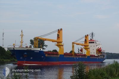
OBIRIX
General Cargo
Current Trip
| Time Travelled | 4 days |
|---|---|
| Remaining Time | --- |
| Distance Travelled | 1155.10 nm |
| Remaining Distance | --- |
| AVG Speed | 10.6 Knopen |
| MAX Speed | 12.1 Knopen |
| AVG Wind | 11.4 knots |
| MAX Wind | 18 knots |
| MIN Temp | 11.8°C / 53.24°F |
| MAX Temp | 16.8°C / 62.24°F |
| Diepgang | 4.5 M |
| Positie ontvangen | 13 h, 5 m geleden |
Current Position
| Lengtegraad | -9.76170° |
|---|---|
| Breedtegraat | 37.52020° |
| Status | Under way using engine |
| Snelheid | 11.2 Knopen |
| Koers | 167.6° |
| Gebied | North Atlantic Ocean |
| Station | T-AIS |
| Positie ontvangen | 13 h, 5 m geleden |
Info
Information
The current position of OBIRIX is in North Atlantic Ocean with coordinates 37.52020° / -9.76170° as reported on 2024-05-20 15:44 by AIS to our vessel tracker app. The vessel's current speed is 11.2 Knopen and is heading at the port of GABES. The estimated time of arrival as calculated by MyShipTracking vessel tracking app is 2024-05-26 09:00 LT
The vessel OBIRIX (IMO: 9504267, MMSI: 314558000) is a General Cargo that was built in 2008 ( 16 Jaar oud ). It's sailing under the flag of [BB] Barbados.
In this page you can find informations about the vessels current position, last detected port calls, and current voyage information. If the vessels is not in coverage by AIS you will find the latest position.
The current position of OBIRIX is detected by our AIS receivers and we are not responsible for the reliability of the data. The last position was recorded while the vessel was in Coverage by the Ais receivers of our vessel tracking app.
The current draught of OBIRIX as reported by AIS is 4.5 meters
Weather
| Temperature | 16.7°C / 62.06°F |
|---|---|
| Wind Speed | 11 knots |
| Direction | 329° NNW |
| Pressure | 1018.4 hPa |
| Humidity | 72.8 % |
| Cloud Coverage | --- |
Featured Company
Last Port Calls
| Port | Arrival | Departure | Time In Port |
|---|---|---|---|
| 2024-05-12 14:28 | 2024-05-16 17:46 | 4 d | |
| 2024-05-02 13:23 | 2024-05-02 22:33 | 9 h | |
| 2024-04-17 12:38 | 2024-04-27 21:44 | 10 d | |
| 2024-03-28 13:57 | 2024-04-05 15:17 | 8 d | |
| 2024-03-14 00:58 | 2024-03-19 20:42 | 5 d |
Most Visited Ports (Last year)
| Port | Arrivals | |
|---|---|---|
| 3 | ||
| 1 | ||
| 1 | ||
| 1 | ||
| 1 | ||
| 1 |
Last Trips
| Origin | Departure | Destination | Arrival | Distance | |
|---|---|---|---|---|---|
| 2024-05-02 23:33 | 2024-05-12 16:28 | 1584.09 nm | |||
| 2024-04-27 21:44 | 2024-05-02 14:23 | 855.15 nm | |||
| 2024-04-05 15:17 | 2024-04-17 12:38 | 1529.27 nm | |||
| 2024-03-19 20:42 | 2024-03-28 13:57 | 1113.22 nm | |||
| 2024-02-27 13:00 | 2024-03-14 00:58 | 3230.18 nm |
Events
| Tijd | Evenement | Details | Positie / Bestemming | Info |
|---|---|---|---|---|
| 2024-05-20 15:51 | Status Changed | Default Under way using engine |
37.49881 / -9.75560
TNGAE
|
Snelheid: 11.2 kn Koers: 167.6° |
| 2024-05-20 15:44 | Status Changed | Under way using engine Default |
37.52020 / -9.76170
TNGAE
|
Snelheid: 11.2 kn Koers: 168° |
| 2024-05-20 15:44 | Buitenbereik |
37.52020 / -9.76170
North Atlantic Ocean
TNGAE
|
Snelheid: 11.2 kn Koers: 167.6° |
|
| 2024-05-20 15:26 | Status Changed | Default Under way using engine |
37.57273 / -9.77614
TNGAE
|
Snelheid: 11.5 kn Koers: 168.3° |
| 2024-05-20 03:36 | Status Changed | Under way using engine Default |
39.74354 / -10.10682
TNGAE
|
Snelheid: 11.1 kn Koers: 178° |
| 2024-05-20 03:26 | Status Changed | Default Under way using engine |
39.77393 / -10.10800
TNGAE
|
Snelheid: 11.2 kn Koers: 178.2° |
| 2024-05-20 03:20 | Gevonden in zee | Portuguese part of the North Atlantic Ocean |
39.79412 / -10.10887
North Atlantic Ocean
TNGAE
|
Snelheid: 11.2 kn Koers: 178.2° |
| 2024-05-20 03:19 | Status Changed | Under way using engine Default |
39.79730 / -10.10898
TNGAE
|
Snelheid: 11.2 kn Koers: 179° |
| 2024-05-20 03:19 | Binnenbereik |
39.79412 / -10.10887
North Atlantic Ocean
TNGAE
|
Snelheid: 11.2 kn Koers: 178.2° |
|
| 2024-05-17 14:32 | Buitenbereik |
49.17080 / -4.97492
English Channel
TNGAE
|
Snelheid: 10.7 kn Koers: 245.6° |