
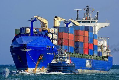
MARIO A
Container Ship
Current Trip
| Time Travelled | 4 days |
|---|---|
| Remaining Time | --- |
| Distance Travelled | 1456.86 nm |
| Remaining Distance | --- |
| AVG Speed | 12.7 Knopen |
| MAX Speed | 15 Knopen |
| AVG Wind | 12.8 knots |
| MAX Wind | 20.8 knots |
| MIN Temp | 15.7°C / 60.26°F |
| MAX Temp | 21.9°C / 71.42°F |
| Diepgang | 7.5 M |
| Positie ontvangen | 1 d geleden |
Current Position
| Lengtegraad | -13.37850° |
|---|---|
| Breedtegraat | 28.55585° |
| Status | Under way using engine |
| Snelheid | 12.8 Knopen |
| Koers | 37.4° |
| Gebied | North Atlantic Ocean |
| Station | T-AIS |
| Positie ontvangen | 1 d geleden |
Info
Information
The current position of MARIO A is in North Atlantic Ocean with coordinates 28.55585° / -13.37850° as reported on 2024-04-26 14:21 by AIS to our vessel tracker app. The vessel's current speed is 12.8 Knopen and is heading at the port of AMBARLI. The estimated time of arrival as calculated by MyShipTracking vessel tracking app is 2024-05-03 04:00 LT
The vessel MARIO A (IMO: 9337377, MMSI: 215177000) is a Container Ship that was built in 2007 ( 17 Jaar oud ). It's sailing under the flag of [MT] Malta.
In this page you can find informations about the vessels current position, last detected port calls, and current voyage information. If the vessels is not in coverage by AIS you will find the latest position.
The current position of MARIO A is detected by our AIS receivers and we are not responsible for the reliability of the data. The last position was recorded while the vessel was in Coverage by the Ais receivers of our vessel tracking app.
The current draught of MARIO A as reported by AIS is 7.5 meters
Weather
| Temperature | 15.8°C / 60.44°F |
|---|---|
| Wind Speed | 8 knots |
| Direction | 343° NNW |
| Pressure | 1013.1 hPa |
| Humidity | 63.4 % |
| Cloud Coverage | --- |
Featured Company
Last Port Calls
| Port | Arrival | Departure | Time In Port |
|---|---|---|---|
| 2024-04-22 23:50 | 2024-04-23 14:58 | 15 h | |
| 2024-04-14 07:28 | 2024-04-14 22:58 | 15 h | |
| 2024-04-14 06:58 | 2024-04-14 07:03 | 5 m | |
| 2024-04-12 21:59 | 2024-04-13 05:20 | 7 h | |
| 2024-03-31 11:29 | 2024-04-01 06:46 | 19 h | |
| 2024-03-26 17:47 | 2024-03-29 10:05 | 2 d | |
| 2024-03-25 06:30 | 2024-03-26 04:16 | 21 h | |
| 2024-03-23 13:02 | 2024-03-23 23:59 | 10 h | |
| 2024-03-11 19:57 | 2024-03-15 16:33 | 3 d | |
| 2024-02-28 18:54 | 2024-02-29 22:06 | 1 d |
Last Trips
| Origin | Departure | Destination | Arrival | Distance | |
|---|---|---|---|---|---|
| 2024-04-14 23:58 | 2024-04-22 23:50 | 1588.36 nm | |||
| 2024-04-14 08:03 | 2024-04-14 08:28 | 0.66 nm | |||
| 2024-04-13 07:20 | 2024-04-14 07:58 | 330.66 nm | |||
| 2024-04-01 07:46 | 2024-04-12 23:59 | 2759.98 nm | |||
| 2024-03-29 10:05 | 2024-03-31 12:29 | 742.64 nm | |||
| 2024-03-26 04:16 | 2024-03-26 17:47 | 220.11 nm | |||
| 2024-03-24 00:59 | 2024-03-25 06:30 | 479.49 nm | |||
| 2024-03-15 16:33 | 2024-03-23 14:02 | 1858.00 nm | |||
| 2024-02-29 22:06 | 2024-03-11 19:57 | 2592.71 nm | |||
| 2024-02-27 19:06 | 2024-02-28 18:54 | 217.55 nm |
Events
| Tijd | Evenement | Details | Positie / Bestemming | Info |
|---|---|---|---|---|
| 2024-04-26 14:26 | Status Changed | Default Under way using engine |
28.57100 / -13.36571
TRAMB
|
Snelheid: 12.8 kn Koers: 37.4° |
| 2024-04-26 14:21 | Status Changed | Under way using engine Default |
28.55585 / -13.37850
TRAMB
|
Snelheid: 12.8 kn Koers: 36° |
| 2024-04-26 14:21 | Buitenbereik |
28.55585 / -13.37850
North Atlantic Ocean
TRAMB
|
Snelheid: 12.8 kn Koers: 37.4° |
|
| 2024-04-26 14:10 | Status Changed | Default Under way using engine |
28.52518 / -13.40518
TRAMB
|
Snelheid: 12.6 kn Koers: 39.1° |
| 2024-04-26 14:03 | Status Changed | Under way using engine Default |
28.50578 / -13.42288
TRAMB
|
Snelheid: 12.9 kn Koers: 39° |
| 2024-04-26 13:13 | Status Changed | Default Under way using engine |
28.36335 / -13.54610
TRAMB
|
Snelheid: 12.8 kn Koers: 35.5° |
| 2024-04-26 12:57 | Status Changed | Under way using engine Default |
28.31699 / -13.58303
TRAMB
|
Snelheid: 13.1 kn Koers: 34° |
| 2024-04-26 12:54 | Binnenbereik |
28.31699 / -13.58303
North Atlantic Ocean
TRAMB
|
Snelheid: 12.8 kn Koers: 33.8° |
|
| 2024-04-26 12:06 | Status Changed | Default Under way using engine |
28.17041 / -13.70539
TRAMB
|
Snelheid: 13 kn Koers: 36.4° |
| 2024-04-26 11:54 | Buitenbereik |
28.13556 / -13.73481
North Atlantic Ocean
TRAMB
|
Snelheid: 13 kn Koers: 36.4° |