
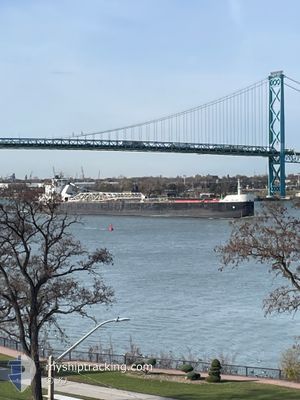
JOHN J. BOLAND
Self Discharging Bulk Carrier
Current Trip
BUFFINGTON
| Time Travelled | 2 days |
|---|---|
| Remaining Time | --- |
| Distance Travelled | 384.97 nm |
| Remaining Distance | --- |
| AVG Speed | 9.1 Knopen |
| MAX Speed | 12.6 Knopen |
| AVG Wind | 17.4 knots |
| MAX Wind | 26 knots |
| MIN Temp | -21.5°C / -6.7°F |
| MAX Temp | -4.4°C / 24.08°F |
| Diepgang | 8.2 M |
| Positie ontvangen | 9 h, 0 m geleden |
Current Position
| Lengtegraad | --- |
|---|---|
| Breedtegraat | --- |
| Status | Under way using engine |
| Snelheid | 7 Knopen |
| Koers | 224.7° |
| Gebied | --- |
| Station | T-AIS |
| Positie ontvangen | 9 h, 0 m geleden |
Info
Information
The current position of JOHN J. BOLAND is in --- with coordinates 41.66114° / -87.38815° as reported on 2025-12-15 00:42 by AIS to our vessel tracker app. The vessel's current speed is 7 Knopen
The vessel JOHN J. BOLAND (IMO: 7318901, MMSI: 366938780) is a Self Discharging Bulk Carrier that was built in 1973 ( 52 Jaar oud ). It's sailing under the flag of [US] USA.
In this page you can find informations about the vessels current position, last detected port calls, and current voyage information. If the vessels is not in coverage by AIS you will find the latest position.
The current position of JOHN J. BOLAND is detected by our AIS receivers and we are not responsible for the reliability of the data. The last position was recorded while the vessel was in Coverage by the Ais receivers of our vessel tracking app.
The current draught of JOHN J. BOLAND as reported by AIS is 8.2 meters
Weather
| Temperature | -11.9°C / 10.58°F |
|---|---|
| Wind Speed | 13 knots |
| Direction | 217° SW |
| Pressure | 1032.1 hPa |
| Humidity | 72.4 % |
| Cloud Coverage | 77 % |
Featured Company
Last Port Calls
| Port | Arrival | Departure | Time In Port |
|---|---|---|---|
| 2025-12-12 12:31 | 2025-12-13 03:41 | 15 h | |
| 2025-12-09 16:10 | 2025-12-11 09:40 | 1 d | |
| 2025-12-07 22:15 | 2025-12-08 17:30 | 19 h | |
| 2025-12-05 10:52 | 2025-12-05 11:50 | 57 m | |
| 2025-12-02 09:10 | 2025-12-03 00:51 | 15 h | |
| 2025-12-01 06:15 | 2025-12-01 13:23 | 7 h | |
| 2025-11-30 16:37 | 2025-11-30 17:26 | 48 m | |
| 2025-11-28 18:50 | 2025-11-28 19:46 | 55 m | |
| 2025-11-24 20:19 | 2025-11-27 05:41 | 2 d | |
| 2025-11-23 07:27 | 2025-11-23 08:16 | 49 m |
Most Visited Ports (Last year)
| Port | Arrivals | |
|---|---|---|
| 60 | ||
| 24 | ||
| 20 | ||
| 19 | ||
| 15 | ||
| 6 |
Last Trips
| Origin | Departure | Destination | Arrival | Distance | |
|---|---|---|---|---|---|
| 2025-12-11 09:40 | 2025-12-12 12:31 | 234.38 nm | |||
| 2025-12-08 17:30 | 2025-12-09 16:10 | 46.53 nm | |||
| 2025-12-05 11:50 | 2025-12-07 22:15 | 350.86 nm | |||
| 2025-12-03 00:51 | 2025-12-05 10:52 | 410.22 nm | |||
| 2025-12-01 13:23 | 2025-12-02 09:10 | 205.61 nm | |||
| 2025-11-30 17:26 | 2025-12-01 06:15 | 143.20 nm | |||
| 2025-11-28 19:46 | 2025-11-30 16:37 | 265.61 nm | |||
| 2025-11-27 05:41 | 2025-11-28 18:50 | 434.46 nm | |||
| 2025-11-23 08:16 | 2025-11-24 20:19 | 350.74 nm | |||
| 2025-11-22 23:07 | 2025-11-23 07:27 | 75.32 nm |
Events
| Tijd | Evenement | Details | Positie / Bestemming | Info |
|---|---|---|---|---|
| 2025-12-15 01:20 | Stop beweging | 1.98 nm, South East of INDIANA HARBOR |
41.64320 / -87.41254
BUFFINGTON
|
Snelheid: Koers: 53° |
| 2025-12-15 00:48 | Status Changed | Default Under way using engine |
41.65499 / -87.39703
BUFFINGTON
|
Snelheid: 7 kn Koers: 224.7° |
| 2025-12-15 00:42 | Status Changed | Under way using engine Default |
41.66114 / -87.38815
BUFFINGTON
|
Snelheid: 7.7 kn Koers: 226° |
| 2025-12-15 00:42 | Buitenbereik |
41.66114 / -87.38815
BUFFINGTON
|
Snelheid: 7 kn Koers: 224.7° |
|
| 2025-12-15 00:28 | Status Changed | Default Under way using engine |
41.68976 / -87.35154
BUFFINGTON
|
Snelheid: 11 kn Koers: 201.1° |
| 2025-12-15 00:09 | Status Changed | Under way using engine Default |
41.74387 / -87.33551
BUFFINGTON
|
Snelheid: 11.8 kn Koers: 156° |
| 2025-12-14 23:55 | Status Changed | Default Under way using engine |
41.78566 / -87.36064
BUFFINGTON
|
Snelheid: 12.1 kn Koers: 159.8° |
| 2025-12-14 19:39 | ETA Changed | 2025/12/15 01:00 2025/12/15 08:00 |
42.61634 / -87.69323
BUFFINGTON
|
Snelheid: 12.5 kn Koers: 183.2° |
| 2025-12-14 19:26 | Status Changed | Under way using engine Default |
42.65938 / -87.69008
BUFFINGTON
|
Snelheid: 12.4 kn Koers: 183° |
| 2025-12-14 19:21 | Binnenbereik |
42.65938 / -87.69008
BUFFINGTON
|
Snelheid: 12.4 kn Koers: 182.5° |