
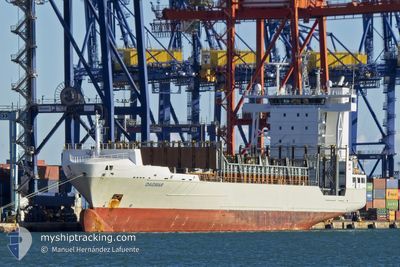
DAGMAR
Container Ship
Current Trip
| Time Travelled | 19 h, 15 mins |
|---|---|
| Remaining Time | 1 day |
| Distance Travelled | 272.61 nm |
| Remaining Distance | 714.87 nm |
| AVG Speed | 14.4 Knopen |
| MAX Speed | 16 Knopen |
| AVG Wind | 6.4 knots |
| MAX Wind | 28 knots |
| MIN Temp | 12°C / 53.6°F |
| MAX Temp | 14.4°C / 57.92°F |
| Diepgang | 8.6 M |
| Positie ontvangen | 4 h, 31 m geleden |
Current Position
| Lengtegraad | --- |
|---|---|
| Breedtegraat | --- |
| Status | Under way using engine |
| Snelheid | 14.1 Knopen |
| Koers | 265.5° |
| Gebied | North Atlantic Ocean |
| Station | T-AIS |
| Positie ontvangen | 4 h, 31 m geleden |
Info
Information
The current position of DAGMAR is in North Atlantic Ocean with coordinates 43.85993° / -7.84767° as reported on 2025-12-11 09:10 by AIS to our vessel tracker app. The vessel's current speed is 14.1 Knopen and is heading at the port of ALGECIRAS. The estimated time of arrival as calculated by MyShipTracking vessel tracking app is 2025-12-13 14:28 LT
The vessel DAGMAR (IMO: 9354399, MMSI: 255826000) is a Container Ship that was built in 2006 ( 19 Jaar oud ). It's sailing under the flag of [PT] Portugal.
In this page you can find informations about the vessels current position, last detected port calls, and current voyage information. If the vessels is not in coverage by AIS you will find the latest position.
The current position of DAGMAR is detected by our AIS receivers and we are not responsible for the reliability of the data. The last position was recorded while the vessel was in Coverage by the Ais receivers of our vessel tracking app.
The current draught of DAGMAR as reported by AIS is 8.6 meters
Weather
| Temperature | 14.3°C / 57.74°F |
|---|---|
| Wind Speed | 28 knots |
| Direction | 206° SSW |
| Pressure | 1015.1 hPa |
| Humidity | 78.8 % |
| Cloud Coverage | 100 % |
Featured Company
Last Port Calls
| Port | Arrival | Departure | Time In Port |
|---|---|---|---|
| 2025-12-08 06:15 | 2025-12-10 19:27 | 2 d | |
| 2025-12-07 06:22 | 2025-12-07 18:39 | 12 h | |
| 2025-12-04 10:09 | 2025-12-04 18:19 | 8 h | |
| 2025-12-03 10:32 | 2025-12-03 16:14 | 5 h | |
| 2025-12-02 12:00 | 2025-12-03 03:30 | 15 h | |
| 2025-11-29 08:44 | 2025-11-29 22:31 | 13 h | |
| 2025-11-27 05:44 | 2025-11-27 14:25 | 8 h | |
| 2025-11-26 19:08 | 2025-11-27 00:44 | 5 h | |
| 2025-11-24 15:04 | 2025-11-24 21:21 | 6 h | |
| 2025-11-22 18:19 | 2025-11-23 15:32 | 21 h |
Last Trips
| Origin | Departure | Destination | Arrival | Distance | |
|---|---|---|---|---|---|
| 2025-12-07 18:39 | 2025-12-08 06:15 | 117.29 nm | |||
| 2025-12-04 18:19 | 2025-12-07 06:22 | 793.79 nm | |||
| 2025-12-03 16:14 | 2025-12-04 10:09 | 115.83 nm | |||
| 2025-12-03 03:30 | 2025-12-03 10:32 | 46.92 nm | |||
| 2025-11-29 22:31 | 2025-12-02 12:00 | 535.33 nm | |||
| 2025-11-27 14:25 | 2025-11-29 08:44 | 345.36 nm | |||
| 2025-11-27 00:44 | 2025-11-27 05:44 | 56.57 nm | |||
| 2025-11-24 21:21 | 2025-11-26 19:08 | 730.14 nm | |||
| 2025-11-23 15:32 | 2025-11-24 15:04 | 3.36 nm | |||
| 2025-11-19 00:59 | 2025-11-22 18:19 | 712.06 nm |
Events
| Tijd | Evenement | Details | Positie / Bestemming | Info |
|---|---|---|---|---|
| 2025-12-11 09:11 | Status Changed | Default Under way using engine |
43.85960 / -7.85536
ESALG
|
Snelheid: 14.1 kn Koers: 265.5° |
| 2025-12-11 09:10 | Buitenbereik |
43.85993 / -7.84767
North Atlantic Ocean
ESALG
|
Snelheid: 14.1 kn Koers: 265.5° |
|
| 2025-12-11 08:58 | Wijzig zee gebeid | Spanish part of the North Atlantic Ocean Spanish part of the Bay of Biscay |
43.86077 / -7.78369
North Atlantic Ocean
ESALG
|
Snelheid: 14.6 kn Koers: 268.9° |
| 2025-12-11 08:07 | Binnenbereik |
43.84494 / -7.55486
Bay of Biscay
ESALG
|
Snelheid: 13.6 kn Koers: 275.8° |
|
| 2025-12-11 04:30 | Status Changed | Default Under way using engine |
43.77271 / -6.33095
ESALG
|
Snelheid: 13.8 kn Koers: 277.9° |
| 2025-12-11 04:24 | Buitenbereik |
43.76852 / -6.29896
Bay of Biscay
ESALG
|
Snelheid: 13.8 kn Koers: 277.9° |
|
| 2025-12-11 04:21 | Status Changed | Under way using engine Default |
43.76637 / -6.28071
ESALG
|
Snelheid: 13.5 kn Koers: 275° |
| 2025-12-11 04:19 | Status Changed | Default Under way using engine |
43.76495 / -6.27048
ESALG
|
Snelheid: 13.8 kn Koers: 271.2° |
| 2025-12-11 04:09 | Status Changed | Under way using engine Default |
43.76224 / -6.21666
ESALG
|
Snelheid: 14.4 kn Koers: 275° |
| 2025-12-11 04:07 | Status Changed | Default Under way using engine |
43.76158 / -6.20582
ESALG
|
Snelheid: 13.4 kn Koers: 276.8° |