
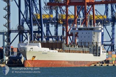
DAGMAR
Container Ship
Current Trip
| Time Travelled | 2 days |
|---|---|
| Remaining Time | 4 h, 22 mins |
| Distance Travelled | 884.99 nm |
| Remaining Distance | 50.91 nm |
| AVG Speed | 12.8 Knots |
| MAX Speed | 16.3 Knots |
| AVG Wind | 14.9 knots |
| MAX Wind | 24 knots |
| MIN Temp | 8.7°C / 47.66°F |
| MAX Temp | 17.5°C / 63.5°F |
| Dybgang | 8.2 m |
| Position Modtaget | 3 m siden |
Current Position
| Longitude | -6.19264° |
|---|---|
| Latitude | 35.90360° |
| Status | Under way using engine |
| Fart | 10 Knots |
| Kurs | 88.2° |
| Område | North Atlantic Ocean |
| Station | T-AIS |
| Position Modtaget | 3 m siden |
Info
Information
The current position of DAGMAR is in North Atlantic Ocean with coordinates 35.90360° / -6.19264° as reported on 2024-04-25 17:24 by AIS to our vessel tracker app. The vessel's current speed is 10 Knots and is heading at the port of ALGECIRAS. The estimated time of arrival as calculated by MyShipTracking vessel tracking app is 2024-04-25 21:49 LT
The vessel DAGMAR (IMO: 9354399, MMSI: 255826000) is a Container Ship that was built in 2006 ( 18 år gamle ). It's sailing under the flag of [PT] Portugal.
In this page you can find informations about the vessels current position, last detected port calls, and current voyage information. If the vessels is not in coverage by AIS you will find the latest position.
The current position of DAGMAR is detected by our AIS receivers and we are not responsible for the reliability of the data. The last position was recorded while the vessel was in Coverage by the Ais receivers of our vessel tracking app.
The current draught of DAGMAR as reported by AIS is 8.2 meters
Weather
| Temperature | 17.4°C / 63.32°F |
|---|---|
| Wind Speed | 13 knots |
| Direction | 247° WSW |
| Pressure | 1010.8 hPa |
| Humidity | 68.7 % |
| Cloud Coverage | 34 % |
Featured Company
Last Port Calls
| Port | Arrival | Departure | Time In Port |
|---|---|---|---|
| 2024-04-21 20:03 | 2024-04-22 20:11 | 1 d | |
| 2024-04-20 18:54 | 2024-04-21 10:18 | 15 h | |
| 2024-04-18 05:17 | 2024-04-18 16:19 | 11 h | |
| 2024-04-16 01:49 | 2024-04-16 10:47 | 8 h | |
| 2024-04-15 10:14 | 2024-04-15 22:48 | 12 h | |
| 2024-04-13 09:47 | 2024-04-14 05:04 | 19 h | |
| 2024-04-11 13:13 | 2024-04-12 02:36 | 13 h | |
| 2024-04-10 22:19 | 2024-04-11 08:15 | 9 h | |
| 2024-04-08 13:29 | 2024-04-08 22:18 | 8 h | |
| 2024-04-06 22:59 | 2024-04-07 21:20 | 22 h |
Most Visited Ports (Last year)
| Port | Arrivals | |
|---|---|---|
| 67 | ||
| 17 | ||
| 17 | ||
| 14 | ||
| 14 | ||
| 11 |
Last Trips
| Origin | Departure | Destination | Arrival | Distance | |
|---|---|---|---|---|---|
| 2024-04-21 12:18 | 2024-04-21 22:03 | 117.02 nm | |||
| 2024-04-18 17:19 | 2024-04-20 20:54 | 775.24 nm | |||
| 2024-04-16 12:47 | 2024-04-18 06:17 | 113.39 nm | |||
| 2024-04-16 00:48 | 2024-04-16 03:49 | 2.65 nm | |||
| 2024-04-14 06:04 | 2024-04-15 12:14 | 439.30 nm | |||
| 2024-04-12 03:36 | 2024-04-13 09:47 | 342.26 nm | |||
| 2024-04-11 09:15 | 2024-04-11 14:13 | 73.96 nm | |||
| 2024-04-09 00:18 | 2024-04-10 23:19 | 725.74 nm | |||
| 2024-04-07 23:20 | 2024-04-08 15:29 | 4.27 nm | |||
| 2024-04-04 06:24 | 2024-04-07 00:59 | 939.43 nm |
Events
| Tid | Hændelsen | Detaljer | Position / Dest | Info |
|---|---|---|---|---|
| 2024-04-25 17:07 | Status er ændret | Under way using engine Default |
35.90983 / -6.25388
ESALG
|
Fart: 10.1 kn Kurs: 102° |
| 2024-04-25 17:02 | Status er ændret | Default Under way using engine |
35.91081 / -6.26071
ESALG
|
Fart: 9.8 kn Kurs: 105° |
| 2024-04-25 16:48 | Ændre havområde | Moroccan part of the North Atlantic Ocean Spanish part of the North Atlantic Ocean |
35.92143 / -6.31771
North Atlantic Ocean
ESALG
|
Fart: 10.1 kn Kurs: 104.2° |
| 2024-04-25 16:36 | Status er ændret | Under way using engine Default |
35.92821 / -6.35373
ESALG
|
Fart: 9.4 kn Kurs: 100° |
| 2024-04-25 16:29 | Status er ændret | Default Under way using engine |
35.93090 / -6.36842
ESALG
|
Fart: 10.1 kn Kurs: 104.8° |
| 2024-04-25 13:50 | Status er ændret | Under way using engine Default |
36.06056 / -6.95475
ESALG
|
Fart: 12 kn Kurs: 103° |
| 2024-04-25 13:50 | Indenfor Dækning |
36.06056 / -6.95475
North Atlantic Ocean
ESALG
|
Fart: 11.9 kn Kurs: 104.4° |
|
| 2024-04-25 13:16 | Status er ændret | Default Under way using engine |
36.08804 / -7.08557
ESALG
|
Fart: 11.8 kn Kurs: 106.9° |
| 2024-04-25 12:47 | Udenfor Dækning |
36.11968 / -7.22508
North Atlantic Ocean
ESALG
|
Fart: 11.8 kn Kurs: 106.9° |
|
| 2024-04-25 12:07 | Fundet i havområde | Spanish part of the North Atlantic Ocean |
36.15988 / -7.40173
North Atlantic Ocean
ESALG
|
Fart: 11.7 kn Kurs: 104.5° |