
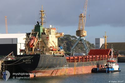
ALEXIA I
General Cargo
Current Trip
| Trip Time | 4 days |
|---|---|
| Trip Distance | 343.30 nm |
| AVG Speed | 4.4 Knopen |
| MAX Speed | 9.4 Knopen |
| Diepgang | 7.8 M |
| AVG Wind | 14.8 knots |
| MAX Wind | 21 knots |
| MIN Temp | 17°C / 62.6°F |
| MAX Temp | 19.8°C / 67.64°F |
| Positie ontvangen | 12 d geleden |
Current Position
| Lengtegraad | --- |
|---|---|
| Breedtegraat | --- |
| Status | Under way using engine |
| Snelheid | 8.4 Knopen |
| Koers | 138.6° |
| Gebied | Aegean Sea |
| Station | T-AIS |
| Positie ontvangen | 12 d geleden |
Info
Information
The current position of ALEXIA I is in Aegean Sea with coordinates 36.39670° / 26.84861° as reported on 2025-11-30 14:48 by AIS to our vessel tracker app. The vessel's current speed is 8.4 Knopen and is currently inside the port of ALEXANDRIA.
The vessel ALEXIA I (IMO: 9365049, MMSI: 538009439) is a General Cargo that was built in 2005 ( 20 Jaar oud ). It's sailing under the flag of [MH] Marshall Is.
In this page you can find informations about the vessels current position, last detected port calls, and current voyage information. If the vessels is not in coverage by AIS you will find the latest position.
The current position of ALEXIA I is detected by our AIS receivers and we are not responsible for the reliability of the data. The last position was recorded while the vessel was in Coverage by the Ais receivers of our vessel tracking app.
The current draught of ALEXIA I as reported by AIS is 7.8 meters
Weather
| Temperature | 18.2°C / 64.76°F |
|---|---|
| Wind Speed | 8 knots |
| Direction | 319° NW |
| Pressure | 1018.6 hPa |
| Humidity | 55.8 % |
| Cloud Coverage | 1 % |
Featured Company
Last Port Calls
| Port | Arrival | Departure | Time In Port |
|---|---|---|---|
| 2025-12-13 01:04 | |||
| 2025-12-06 14:57 | 2025-12-08 15:45 | 2 d | |
| 2025-12-02 13:25 | 2025-12-06 14:45 | 4 d | |
| 2025-11-24 02:35 | 2025-11-25 17:52 | 1 d | |
| 2025-11-14 07:47 | 2025-11-16 19:23 | 2 d | |
| 2025-11-06 16:04 | 2025-11-09 13:53 | 2 d | |
| 2025-11-02 23:14 | 2025-11-06 01:07 | 3 d | |
| 2025-10-07 16:56 | 2025-10-13 19:07 | 6 d | |
| 2025-10-05 12:00 | 2025-10-07 10:32 | 1 d | |
| 2025-10-01 14:48 |
Most Visited Ports (Last year)
| Port | Arrivals | |
|---|---|---|
| 3 | ||
| 2 | ||
| 2 | ||
| 1 | ||
| 1 | ||
| 1 |
Last Trips
| Origin | Departure | Destination | Arrival | Distance | |
|---|---|---|---|---|---|
| 2025-12-08 15:45 | 2025-12-13 01:04 | 343.30 nm | |||
| 2025-12-06 14:45 | 2025-12-06 14:57 | 0.59 nm | |||
| 2025-11-25 17:52 | 2025-12-02 13:25 | 1359.09 nm | |||
| 2025-11-16 19:23 | 2025-11-24 02:35 | 1657.38 nm | |||
| 2025-11-09 13:53 | 2025-11-14 07:47 | 920.54 nm | |||
| 2025-11-06 01:07 | 2025-11-06 16:04 | 123.64 nm | |||
| 2025-10-13 19:07 | 2025-11-02 23:14 | 1249.15 nm | |||
| 2025-10-07 10:32 | 2025-10-07 16:56 | 10.75 nm | |||
| 2025-10-01 14:48 | 2025-10-05 12:00 | 487.78 nm |
Events
| Tijd | Evenement | Details | Positie / Bestemming | Info |
|---|---|---|---|---|
| 2025-12-13 00:10 | Stop beweging |
31.18731 / 29.87872
[EG] ALEXANDRIA
|
Snelheid: 0.1 kn Koers: 141° |
|
| 2025-12-12 23:04 | Aankomsthaven |
|
31.16222 / 29.84655
[EG] ALEXANDRIA
|
Snelheid: 8.6 kn Koers: 95° |
| 2025-12-12 22:21 | Start beweging | 3.44 nm, North of EL DEKHEILA |
31.20377 / 29.80081
EG AKI
|
Snelheid: 3.8 kn Koers: 172° |
| 2025-12-12 22:09 | Stop beweging | 3.66 nm, North West of ALEXANDRIA |
31.20991 / 29.79966
EG AKI
|
Snelheid: 0.3 kn Koers: 139° |
| 2025-12-12 11:08 | Start beweging |
31.40833 / 29.42333
EG AKI
|
Snelheid: 5 kn Koers: 138° |
|
| 2025-12-12 09:23 | Stop beweging |
31.42167 / 29.39167
EG AKI
|
Snelheid: Koers: -1° |
|
| 2025-12-09 20:41 | Start beweging |
31.20120 / 29.36715
EG AKI
|
Snelheid: 3.2 kn Koers: 308° |
|
| 2025-12-09 13:42 | Stop beweging |
31.33667 / 29.30333
EG AKI
|
Snelheid: Koers: -1° |
|
| 2025-12-08 13:45 | Vertrekhaven |
|
31.34241 / 30.09229
EG AKI
|
Snelheid: 7.3 kn Koers: 20° |
| 2025-12-08 13:37 | Start beweging |
31.32702 / 30.08439
[EG] ABU QIR
|
Snelheid: 5.4 kn Koers: 42° |