
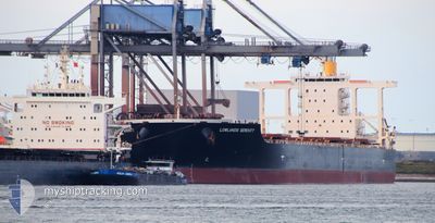
YM SERENITY
Bulk Carrier
Current Trip
| Time Travelled | 31 days |
|---|---|
| Remaining Time | --- |
| Distance Travelled | 6488.16 nm |
| Remaining Distance | 9.99 nm |
| AVG Speed | 12.1 Noeuds |
| MAX Speed | 16.8 Noeuds |
| AVG Wind | 10.7 knots |
| MAX Wind | 23 knots |
| MIN Temp | 13.5°C / 56.3°F |
| MAX Temp | 30.2°C / 86.36°F |
| Tirant d eau | 8.4 m |
| Position reçue | 3 m depuis |
Current Position
| Longitude | 117.35693° |
|---|---|
| Latitude | -20.55054° |
| Etat | At anchor |
| Vitesse | 0.1 Noeuds |
| Parcours | 146° |
| Zone | Indian Ocean |
| Station | T-AIS |
| Position reçue | 3 m depuis |
Info
Information
The current position of YM SERENITY is in Indian Ocean with coordinates -20.55054° / 117.35693° as reported on 2024-05-25 20:00 by AIS to our vessel tracker app. The vessel's current speed is 0.1 Noeuds and is heading at the port of PORT WALCOTT. The estimated time of arrival as calculated by MyShipTracking vessel tracking app is 2024-05-22 20:30 LT
The vessel YM SERENITY (IMO: 9581758, MMSI: 370096000) is a Bulk Carrier that was built in 2011 ( 13 Age ). It's sailing under the flag of [PA] Panama.
In this page you can find informations about the vessels current position, last detected port calls, and current voyage information. If the vessels is not in coverage by AIS you will find the latest position.
The current position of YM SERENITY is detected by our AIS receivers and we are not responsible for the reliability of the data. The last position was recorded while the vessel was in Coverage by the Ais receivers of our vessel tracking app.
The current draught of YM SERENITY as reported by AIS is 8.4 meters
Weather
| Temperature | 24.9°C / 76.82°F |
|---|---|
| Wind Speed | 13 knots |
| Direction | 107° ESE |
| Pressure | 1015.7 hPa |
| Humidity | 55.3 % |
| Cloud Coverage | --- |
Featured Company
Last Port Calls
| Port | Arrival | Departure | Time In Port |
|---|---|---|---|
| 2024-04-23 00:03 | 2024-04-24 11:58 | 1 d | |
| 2024-03-15 20:24 | 2024-03-18 09:07 | 2 d |
Most Visited Ports (Last year)
| Port | Arrivals | |
|---|---|---|
| 3 | ||
| 1 | ||
| 1 | ||
| 1 | ||
| 1 | ||
| 1 |
Last Trips
| Origin | Departure | Destination | Arrival | Distance | |
|---|---|---|---|---|---|
| 2024-03-18 09:07 | 2024-04-23 00:03 | 3774.78 nm | |||
| 2024-02-11 13:54 | 2024-03-15 20:24 | 8297.99 nm |
Events
| Heure | Evenement | Détails | Position/ Destination | Info |
|---|---|---|---|---|
| 2024-05-25 11:12 | Etat Changé | At anchor Default |
-20.55463 / 117.36060
AU PWL
|
Vitesse: Parcours: 322° |
| 2024-05-25 11:09 | Etat Changé | Default At anchor |
-20.55460 / 117.36057
AU PWL
|
Vitesse: Parcours: 321° |
| 2024-05-25 00:39 | Etat Changé | At anchor Default |
-20.55494 / 117.35993
AU PWL
|
Vitesse: Parcours: 339° |
| 2024-05-25 00:33 | Etat Changé | Default At anchor |
-20.55491 / 117.35992
AU PWL
|
Vitesse: Parcours: 340° |
| 2024-05-24 14:09 | Etat Changé | At anchor Default |
-20.55505 / 117.35968
AU PWL
|
Vitesse: Parcours: 343° |
| 2024-05-24 14:06 | Etat Changé | Default At anchor |
-20.55510 / 117.35970
AU PWL
|
Vitesse: 0.1 kn Parcours: 341° |
| 2024-05-24 08:15 | Etat Changé | At anchor Default |
-20.55087 / 117.35707
AU PWL
|
Vitesse: 0.1 kn Parcours: 142° |
| 2024-05-24 08:09 | Etat Changé | Default At anchor |
-20.55090 / 117.35697
AU PWL
|
Vitesse: 0.1 kn Parcours: 142° |
| 2024-05-24 08:00 | Etat Changé | At anchor Default |
-20.55097 / 117.35698
AU PWL
|
Vitesse: Parcours: 140° |
| 2024-05-24 07:51 | Etat Changé | Default At anchor |
-20.55096 / 117.35691
AU PWL
|
Vitesse: Parcours: 139° |