
SEACALM
Tanker A
Current Trip
| Time Travelled | 2 days |
|---|---|
| Remaining Time | 3 days |
| Distance Travelled | 517.82 nm |
| Remaining Distance | 964.49 nm |
| AVG Speed | 11.1 Noeuds |
| MAX Speed | 12.8 Noeuds |
| AVG Wind | 5.2 knots |
| MAX Wind | 9.4 knots |
| MIN Temp | 7.5°C / 45.5°F |
| MAX Temp | 18.9°C / 66.02°F |
| Tirant d eau | 8.2 m |
| Position reçue | 3 h, 37 m depuis |
Current Position
| Longitude | 19.22970° |
|---|---|
| Latitude | 39.64766° |
| Etat | Under way using engine |
| Vitesse | 11.7 Noeuds |
| Parcours | 155.7° |
| Zone | Ionian Sea |
| Station | T-AIS |
| Position reçue | 3 h, 37 m depuis |
Info
Information
The current position of SEACALM is in Ionian Sea with coordinates 39.64766° / 19.22970° as reported on 2024-04-29 01:24 by AIS to our vessel tracker app. The vessel's current speed is 11.7 Noeuds and is heading at the port of CEYHAN. The estimated time of arrival as calculated by MyShipTracking vessel tracking app is 2024-05-02 13:17 LT
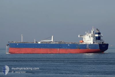
The vessel SEACALM (IMO: 9773753, MMSI: 538007376) is a Tanker A It's sailing under the flag of [MH] Marshall Is.
In this page you can find informations about the vessels current position, last detected port calls, and current voyage information. If the vessels is not in coverage by AIS you will find the latest position.
The current position of SEACALM is detected by our AIS receivers and we are not responsible for the reliability of the data. The last position was recorded while the vessel was in Coverage by the Ais receivers of our vessel tracking app.
The current draught of SEACALM as reported by AIS is 8.2 meters
Weather
| Temperature | 18.3°C / 64.94°F |
|---|---|
| Wind Speed | 9 knots |
| Direction | 104° ESE |
| Pressure | 1017.6 hPa |
| Humidity | 72.4 % |
| Cloud Coverage | 43 % |
Featured Company
Events
| Heure | Evenement | Détails | Position/ Destination | Info |
|---|---|---|---|---|
| 2024-04-29 01:29 | Etat Changé | Default Under way using engine |
39.63224 / 19.23872
TRCEY
|
Vitesse: 11.7 kn Parcours: 155.7° |
| 2024-04-29 01:24 | Hors de la zone couverte |
39.64766 / 19.22970
Ionian Sea
TRCEY
|
Vitesse: 11.7 kn Parcours: 155.7° |
|
| 2024-04-29 00:47 | Detecté en mer | Greek part of the Ionian Sea |
39.75720 / 19.16561
Ionian Sea
TRCEY
|
Vitesse: 11.4 kn Parcours: 157.1° |
| 2024-04-28 22:59 | Changement de zone | Greek part of the Adriatic Sea Italian part of the Adriatic Sea |
40.07882 / 18.98962
Adriatic Sea
TRCEY
|
Vitesse: 11.8 kn Parcours: 156.2° |
| 2024-04-28 15:07 | Etat Changé | Under way using engine Default |
41.27987 / 17.84408
TRCEY
|
Vitesse: 11.9 kn Parcours: 128° |
| 2024-04-28 15:00 | Etat Changé | Default Under way using engine |
41.29478 / 17.81864
TRCEY
|
Vitesse: 11.8 kn Parcours: 127.4° |
| 2024-04-28 14:42 | Etat Changé | Under way using engine Default |
41.33049 / 17.75718
TRCEY
|
Vitesse: 11.8 kn Parcours: 130° |
| 2024-04-28 14:34 | Etat Changé | Default Under way using engine |
41.34645 / 17.73123
TRCEY
|
Vitesse: 11.9 kn Parcours: 129.5° |
| 2024-04-28 14:13 | Etat Changé | Under way using engine Default |
41.39116 / 17.65914
TRCEY
|
Vitesse: 12 kn Parcours: 129° |
| 2024-04-28 14:12 | Etat Changé | Default Under way using engine |
41.39328 / 17.65566
TRCEY
|
Vitesse: 12 kn Parcours: 129° |