
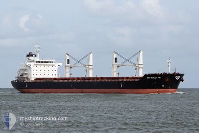
RAVNI KOTARI
Bulk Carrier
Current Trip
| Time Travelled | 20 days |
|---|---|
| Remaining Time | --- |
| Distance Travelled | 2416.68 nm |
| Remaining Distance | --- |
| AVG Speed | 11.7 Noeuds |
| MAX Speed | 14.3 Noeuds |
| AVG Wind | 9.3 knots |
| MAX Wind | 25.7 knots |
| MIN Temp | 18.7°C / 65.66°F |
| MAX Temp | 32.2°C / 89.96°F |
| Tirant d eau | 6.4 m |
| Position reçue | 3 d depuis |
Current Position
| Longitude | 100.83725° |
|---|---|
| Latitude | 13.14500° |
| Etat | At anchor |
| Vitesse | |
| Parcours | 199° |
| Zone | Gulf of Thailand |
| Station | T-AIS |
| Position reçue | 3 d depuis |
Info
Information
The current position of RAVNI KOTARI is in Gulf of Thailand with coordinates 13.14500° / 100.83725° as reported on 2024-05-13 13:34 by AIS to our vessel tracker app. The vessel's current speed is 0 Noeuds
The vessel RAVNI KOTARI (IMO: 9489168, MMSI: 311000296) is a Bulk Carrier that was built in 2010 ( 14 Age ). It's sailing under the flag of [BS] Bahamas.
In this page you can find informations about the vessels current position, last detected port calls, and current voyage information. If the vessels is not in coverage by AIS you will find the latest position.
The current position of RAVNI KOTARI is detected by our AIS receivers and we are not responsible for the reliability of the data. The last position was recorded while the vessel was in Coverage by the Ais receivers of our vessel tracking app.
The current draught of RAVNI KOTARI as reported by AIS is 6.4 meters
Weather
| Temperature | 30.8°C / 87.44°F |
|---|---|
| Wind Speed | 14 knots |
| Direction | 178° S |
| Pressure | 1009.1 hPa |
| Humidity | 75.6 % |
| Cloud Coverage | 63 % |
Featured Company
Events
| Heure | Evenement | Détails | Position/ Destination | Info |
|---|---|---|---|---|
| 2024-05-13 13:36 | Etat Changé | Default At anchor |
13.14500 / 100.83667
TH KSI
|
Vitesse: Parcours: 199° |
| 2024-05-13 13:34 | Hors de la zone couverte |
13.14500 / 100.83725
Gulf of Thailand
|
Vitesse: Parcours: 195.3° |
|
| 2024-05-13 12:10 | Etat Changé | At anchor Default |
13.14510 / 100.83661
TH KSI
|
Vitesse: Parcours: 171° |
| 2024-05-13 12:07 | Etat Changé | Default At anchor |
13.14511 / 100.83660
TH KSI
|
Vitesse: Parcours: 168° |
| 2024-05-13 11:58 | Etat Changé | At anchor Default |
13.14511 / 100.83638
TH KSI
|
Vitesse: Parcours: 164° |
| 2024-05-13 11:54 | Etat Changé | Default At anchor |
13.14509 / 100.83632
TH KSI
|
Vitesse: Parcours: 164° |
| 2024-05-13 11:40 | Etat Changé | At anchor Default |
13.14511 / 100.83627
TH KSI
|
Vitesse: Parcours: 162° |
| 2024-05-13 11:37 | Etat Changé | Default At anchor |
13.14510 / 100.83624
TH KSI
|
Vitesse: Parcours: 155° |
| 2024-05-13 11:31 | Etat Changé | At anchor Default |
13.14497 / 100.83605
TH KSI
|
Vitesse: Parcours: 153° |
| 2024-05-13 11:13 | Dans la zone couverte |
13.14497 / 100.83605
Gulf of Thailand
|
Vitesse: Parcours: 195.3° |