
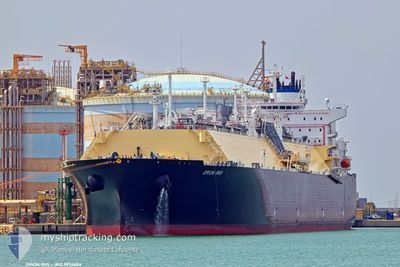
ORION IRIS
Tanker D
Current Trip
| Time Travelled | 11 h, 0 mins |
|---|---|
| Remaining Time | --- |
| Distance Travelled | 150.51 nm |
| Remaining Distance | --- |
| AVG Speed | 13.4 Noeuds |
| MAX Speed | 16.9 Noeuds |
| AVG Wind | 17.2 knots |
| MAX Wind | 22.8 knots |
| MIN Temp | 0.2°C / 32.36°F |
| MAX Temp | 7.5°C / 45.5°F |
| Tirant d eau | 9.2 m |
| Position reçue | 2 m depuis |
Current Position
| Longitude | --- |
|---|---|
| Latitude | --- |
| Etat | Under way using engine |
| Vitesse | 16.9 Noeuds |
| Parcours | 117.7° |
| Zone | North Atlantic Ocean |
| Station | T-AIS |
| Position reçue | 2 m depuis |
Info
Information
The current position of ORION IRIS is in North Atlantic Ocean with coordinates 36.49532° / -74.96903° as reported on 2025-12-11 23:42 by AIS to our vessel tracker app. The vessel's current speed is 16.9 Noeuds and is heading at the port of TERNEUZEN. The estimated time of arrival as calculated by MyShipTracking vessel tracking app is 2025-12-16 21:00 LT
The vessel ORION IRIS (IMO: 9956604, MMSI: 228243350) is a Tanker D It's sailing under the flag of [FR] France.
In this page you can find informations about the vessels current position, last detected port calls, and current voyage information. If the vessels is not in coverage by AIS you will find the latest position.
The current position of ORION IRIS is detected by our AIS receivers and we are not responsible for the reliability of the data. The last position was recorded while the vessel was in Coverage by the Ais receivers of our vessel tracking app.
The current draught of ORION IRIS as reported by AIS is 9.2 meters
Weather
| Temperature | 7.5°C / 45.5°F |
|---|---|
| Wind Speed | 16 knots |
| Direction | 304° NW |
| Pressure | 1014.1 hPa |
| Humidity | 53.5 % |
| Cloud Coverage | 61 % |
Featured Company
Last Port Calls
| Port | Arrival | Departure | Time In Port |
|---|---|---|---|
| 2025-12-10 09:57 | 2025-12-11 07:44 | 21 h | |
| 2025-12-02 14:07 | 2025-12-03 10:47 | 20 h | |
| 2025-10-29 07:44 | 2025-10-30 13:09 | 1 d | |
| 2025-10-16 07:35 | 2025-10-17 07:15 | 23 h |
Most Visited Ports (Last year)
| Port | Arrivals | |
|---|---|---|
| 7 | ||
| 2 | ||
| 2 | ||
| 1 | ||
| 1 | ||
| 1 |
Last Trips
| Origin | Departure | Destination | Arrival | Distance | |
|---|---|---|---|---|---|
| 2025-12-03 10:47 | 2025-12-10 09:57 | 2095.86 nm | |||
| 2025-10-30 13:09 | 2025-12-02 14:07 | 3916.81 nm | |||
| 2025-10-17 07:15 | 2025-10-29 07:44 | 3631.87 nm | |||
| 2025-09-12 07:14 | 2025-10-16 07:35 | 8026.78 nm |
Events
| Heure | Evenement | Détails | Position/ Destination | Info |
|---|---|---|---|---|
| 2025-12-11 16:57 | Etat Changé | Under way using engine Default |
37.43039 / -76.08803
FOR ORDERS
|
Vitesse: 15.9 kn Parcours: 207° |
| 2025-12-11 16:55 | Dans la zone couverte |
37.43039 / -76.08803
North Atlantic Ocean
FOR ORDERS
|
Vitesse: 15.6 kn Parcours: 179.5° |
|
| 2025-12-11 13:43 | Etat Changé | Default Under way using engine |
38.23528 / -76.26172
FOR ORDERS
|
Vitesse: 14.4 kn Parcours: 160° |
| 2025-12-11 13:38 | Hors de la zone couverte |
38.25571 / -76.27113
North Atlantic Ocean
FOR ORDERS
|
Vitesse: 14.4 kn Parcours: 160° |
|
| 2025-12-11 13:26 | Etat Changé | Under way using engine Default |
38.29749 / -76.28891
FOR ORDERS
|
Vitesse: 13.8 kn Parcours: 155° |
| 2025-12-11 13:15 | Etat Changé | Default Under way using engine |
38.33686 / -76.31104
FOR ORDERS
|
Vitesse: 13.6 kn Parcours: 149.2° |
| 2025-12-11 13:15 | Etat Changé | Under way using engine Default |
38.33800 / -76.31190
FOR ORDERS
|
Vitesse: 13.5 kn Parcours: 151° |
| 2025-12-11 12:59 | Etat Changé | Default Under way using engine |
38.38817 / -76.34848
FOR ORDERS
|
Vitesse: 8.7 kn Parcours: 126.3° |
| 2025-12-11 12:44 | Démarrage | 0.34 nm, North East of COVE POINT |
38.40842 / -76.38045
FOR ORDERS
|
Vitesse: 3.2 kn Parcours: 83° |
| 2025-12-11 12:44 | PORT DE DEPART |
|
38.40842 / -76.38045
FOR ORDERS
|
Vitesse: 2.8 kn Parcours: 59° |