
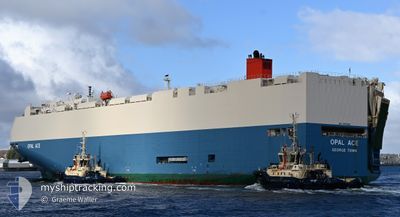
OPAL ACE
Vehicles Carrier
Current Trip
| Time Travelled | 24 days |
|---|---|
| Remaining Time | --- |
| Distance Travelled | 10145.72 nm |
| Remaining Distance | --- |
| AVG Speed | 17.5 Noeuds |
| MAX Speed | 20.8 Noeuds |
| AVG Wind | 10.6 knots |
| MAX Wind | 21 knots |
| MIN Temp | 16°C / 60.8°F |
| MAX Temp | 30.6°C / 87.08°F |
| Tirant d eau | 9.3 m |
| Position reçue | 3 d depuis |
Current Position
| Longitude | 17.21079° |
|---|---|
| Latitude | -33.67233° |
| Etat | Under way using engine |
| Vitesse | 17 Noeuds |
| Parcours | 316.5° |
| Zone | South Atlantic Ocean |
| Station | T-AIS |
| Position reçue | 3 d depuis |
Info
Information
The current position of OPAL ACE is in South Atlantic Ocean with coordinates -33.67233° / 17.21079° as reported on 2024-05-02 23:13 by AIS to our vessel tracker app. The vessel's current speed is 17 Noeuds and is heading at the port of GIBRALTAR. The estimated time of arrival as calculated by MyShipTracking vessel tracking app is 2024-05-14 12:00 LT
The vessel OPAL ACE (IMO: 9539183, MMSI: 319058000) is a Vehicles Carrier that was built in 2011 ( 13 Age ). It's sailing under the flag of [KY] Cayman Is.
In this page you can find informations about the vessels current position, last detected port calls, and current voyage information. If the vessels is not in coverage by AIS you will find the latest position.
The current position of OPAL ACE is detected by our AIS receivers and we are not responsible for the reliability of the data. The last position was recorded while the vessel was in Coverage by the Ais receivers of our vessel tracking app.
The current draught of OPAL ACE as reported by AIS is 9.3 meters
Weather
| Temperature | 24.4°C / 75.92°F |
|---|---|
| Wind Speed | 14 knots |
| Direction | 140° SE |
| Pressure | 1011.6 hPa |
| Humidity | 68 % |
| Cloud Coverage | 15 % |
Featured Company
Last Port Calls
| Port | Arrival | Departure | Time In Port |
|---|---|---|---|
| 2024-04-09 21:06 | 2024-04-12 07:42 | 2 d | |
| 2024-04-04 21:29 | 2024-04-05 07:01 | 9 h | |
| 2024-04-02 21:44 | 2024-04-03 04:45 | 7 h | |
| 2024-03-29 20:27 | 2024-03-30 08:08 | 11 h | |
| 2024-03-27 05:56 | 2024-03-27 17:56 | 12 h | |
| 2024-03-18 14:30 | 2024-03-19 04:15 | 13 h |
Last Trips
| Origin | Departure | Destination | Arrival | Distance | |
|---|---|---|---|---|---|
| 2024-04-05 16:01 | 2024-04-10 06:06 | 626.43 nm | |||
| 2024-04-03 13:45 | 2024-04-05 06:29 | 381.64 nm | |||
| 2024-03-30 16:08 | 2024-04-03 06:44 | 1317.31 nm | |||
| 2024-03-28 01:56 | 2024-03-30 04:27 | 755.05 nm | |||
| 2024-03-19 12:15 | 2024-03-27 13:56 | 2489.13 nm | |||
| 2024-02-10 03:49 | 2024-03-18 22:30 | 12546.98 nm |
Events
| Heure | Evenement | Détails | Position/ Destination | Info |
|---|---|---|---|---|
| 2024-05-02 23:19 | Etat Changé | Default Under way using engine |
-33.65231 / 17.18945
GI GIB
|
Vitesse: 17 kn Parcours: 316.5° |
| 2024-05-02 23:13 | Hors de la zone couverte |
-33.67233 / 17.21079
South Atlantic Ocean
GI GIB
|
Vitesse: 17 kn Parcours: 316.5° |
|
| 2024-05-02 23:13 | Etat Changé | Under way using engine Default |
-33.67373 / 17.21231
GI GIB
|
Vitesse: 17.1 kn Parcours: 319° |
| 2024-05-02 23:11 | Etat Changé | Default Under way using engine |
-33.67837 / 17.21717
GI GIB
|
Vitesse: 17.1 kn Parcours: 317.8° |
| 2024-05-02 23:05 | Etat Changé | Under way using engine Default |
-33.70081 / 17.24116
GI GIB
|
Vitesse: 17.3 kn Parcours: 319° |
| 2024-05-02 22:58 | Etat Changé | Default Under way using engine |
-33.72879 / 17.26706
GI GIB
|
Vitesse: 18.1 kn Parcours: 333.4° |
| 2024-05-02 22:52 | Etat Changé | Under way using engine Default |
-33.75350 / 17.28211
GI GIB
|
Vitesse: 18 kn Parcours: 333° |
| 2024-05-02 22:36 | Etat Changé | Default Under way using engine |
-33.82748 / 17.33353
GI GIB
|
Vitesse: 18.6 kn Parcours: 328.7° |
| 2024-05-02 22:24 | Etat Changé | Under way using engine Default |
-33.87927 / 17.37364
GI GIB
|
Vitesse: 18.1 kn Parcours: 320° |
| 2024-05-02 22:24 | Dans la zone couverte |
-33.87927 / 17.37364
South Atlantic Ocean
GI GIB
|
Vitesse: 18.9 kn Parcours: 320.4° |