
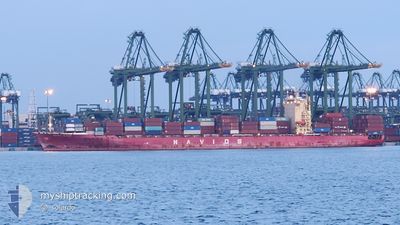
NAVIOS DESTINY
Container Ship
Current Trip
CN TAO
| Time Travelled | 4 days |
|---|---|
| Remaining Time | --- |
| Distance Travelled | 1076.02 nm |
| Remaining Distance | --- |
| AVG Speed | 14.3 Noeuds |
| MAX Speed | 16.9 Noeuds |
| AVG Wind | 6.5 knots |
| MAX Wind | 14 knots |
| MIN Temp | 25.9°C / 78.62°F |
| MAX Temp | 30.3°C / 86.54°F |
| Tirant d eau | 11.4 m |
| Position reçue | 4 d depuis |
Current Position
| Longitude | 113.79750° |
|---|---|
| Latitude | 22.32000° |
| Etat | Under way using engine |
| Vitesse | 14.6 Noeuds |
| Parcours | 168° |
| Zone | South China Sea |
| Station | T-AIS |
| Position reçue | 4 d depuis |
Info
Information
The current position of NAVIOS DESTINY is in South China Sea with coordinates 22.32000° / 113.79750° as reported on 2024-05-12 02:56 by AIS to our vessel tracker app. The vessel's current speed is 14.6 Noeuds
The vessel NAVIOS DESTINY (IMO: 9352418, MMSI: 538003278) is a Container Ship that was built in 2009 ( 15 Age ). It's sailing under the flag of [MH] Marshall Is.
In this page you can find informations about the vessels current position, last detected port calls, and current voyage information. If the vessels is not in coverage by AIS you will find the latest position.
The current position of NAVIOS DESTINY is detected by our AIS receivers and we are not responsible for the reliability of the data. The last position was recorded while the vessel was in Coverage by the Ais receivers of our vessel tracking app.
The current draught of NAVIOS DESTINY as reported by AIS is 11.4 meters
Weather
| Temperature | 29.8°C / 85.64°F |
|---|---|
| Wind Speed | 6 knots |
| Direction | 115° ESE |
| Pressure | 1008.9 hPa |
| Humidity | 71.9 % |
| Cloud Coverage | 80 % |
Featured Company
Last Trips
| Origin | Departure | Destination | Arrival | Distance | |
|---|---|---|---|---|---|
| 2024-05-08 10:04 | 2024-05-12 00:51 | 1057.39 nm | |||
| 2024-05-04 11:59 | 2024-05-07 23:51 | 693.67 nm | |||
| 2024-03-30 02:48 | 2024-03-31 15:20 | 441.60 nm | |||
| 2024-03-21 23:30 | 2024-03-29 11:29 | 2499.37 nm | |||
| 2024-02-24 03:39 | 2024-03-21 06:28 | 8189.72 nm |
Events
| Heure | Evenement | Détails | Position/ Destination | Info |
|---|---|---|---|---|
| 2024-05-15 09:21 | Arret |
6.33933 / 107.50150
CN TAO
|
Vitesse: 0.3 kn Parcours: 249° |
|
| 2024-05-12 03:04 | Etat Changé | Default Under way using engine |
22.28800 / 113.80450
CN TAO
|
Vitesse: 14.6 kn Parcours: 168° |
| 2024-05-12 02:56 | Etat Changé | Under way using engine Default |
22.32000 / 113.79750
CN TAO
|
Vitesse: 14.4 kn Parcours: 168° |
| 2024-05-12 02:56 | Dans la zone couverte |
22.32000 / 113.79750
South China Sea
|
Vitesse: 14.6 kn Parcours: 168° |
|
| 2024-05-12 02:56 | Hors de la zone couverte |
22.32000 / 113.79750
South China Sea
|
Vitesse: 14.6 kn Parcours: 168° |
|
| 2024-05-12 01:27 | Démarrage | 2.02 nm, South of NANSHA |
22.64106 / 113.68800
CN TAO
|
Vitesse: 7.4 kn Parcours: 151° |
| 2024-05-12 01:20 | PORT DE DEPART |
|
22.64524 / 113.68619
CN TAO
|
Vitesse: 1.6 kn Parcours: 316° |
| 2024-05-11 17:02 | Arret |
22.64500 / 113.68217
[CN] NANSHA
|
Vitesse: 0.1 kn Parcours: 350° |
|
| 2024-05-11 16:51 | Port d'arrivée |
|
22.64487 / 113.68314
[CN] NANSHA
|
Vitesse: 5.8 kn Parcours: 326° |
| 2024-05-10 22:01 | Hors de la zone couverte |
23.33542 / 117.63559
South China Sea
|
Vitesse: 18.1 kn Parcours: 218° |