
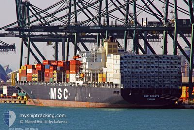
MSC SORAYA
Container Ship
Current Trip
| Time Travelled | 6 days |
|---|---|
| Remaining Time | 1 day |
| Distance Travelled | 2825.07 nm |
| Remaining Distance | 828.94 nm |
| AVG Speed | 18.7 Noeuds |
| MAX Speed | 20.5 Noeuds |
| AVG Wind | 14.1 knots |
| MAX Wind | 30.7 knots |
| MIN Temp | 10.2°C / 50.36°F |
| MAX Temp | 27.5°C / 81.5°F |
| Tirant d eau | 15.1 m |
| Position reçue | 9 h, 44 m depuis |
Current Position
| Longitude | --- |
|---|---|
| Latitude | --- |
| Etat | Under way using engine |
| Vitesse | 18.7 Noeuds |
| Parcours | 159.3° |
| Zone | North Atlantic Ocean |
| Station | T-AIS |
| Position reçue | 9 h, 44 m depuis |
Info
Information
The current position of MSC SORAYA is in North Atlantic Ocean with coordinates 11.53577° / -17.49327° as reported on 2025-12-05 02:49 by AIS to our vessel tracker app. The vessel's current speed is 18.7 Noeuds and is heading at the port of ABIDJAN. The estimated time of arrival as calculated by MyShipTracking vessel tracking app is 2025-12-07 07:23 LT
The vessel MSC SORAYA (IMO: 9372494, MMSI: 370271000) is a Container Ship that was built in 2008 ( 17 Age ). It's sailing under the flag of [PA] Panama.
In this page you can find informations about the vessels current position, last detected port calls, and current voyage information. If the vessels is not in coverage by AIS you will find the latest position.
The current position of MSC SORAYA is detected by our AIS receivers and we are not responsible for the reliability of the data. The last position was recorded while the vessel was in Coverage by the Ais receivers of our vessel tracking app.
The current draught of MSC SORAYA as reported by AIS is 15.1 meters
Weather
| Temperature | 27.7°C / 81.86°F |
|---|---|
| Wind Speed | 4 knots |
| Direction | 95° E |
| Pressure | 1011.3 hPa |
| Humidity | 70 % |
| Cloud Coverage | 83 % |
Featured Company
Last Port Calls
| Port | Arrival | Departure | Time In Port |
|---|---|---|---|
| 2025-11-28 05:10 | 2025-11-29 05:32 | 1 d | |
| 2025-11-26 03:53 | 2025-11-27 04:34 | 1 d | |
| 2025-11-22 10:58 | 2025-11-23 06:42 | 19 h | |
| 2025-11-20 03:07 | 2025-11-22 00:52 | 1 d | |
| 2025-11-09 07:26 | 2025-11-10 20:22 | 1 d | |
| 2025-11-08 07:42 | 2025-11-08 21:06 | 13 h | |
| 2025-11-04 21:16 | 2025-11-06 23:36 | 2 d | |
| 2025-11-02 17:20 | 2025-11-04 07:00 | 1 d | |
| 2025-10-26 20:34 | 2025-10-27 08:18 | 11 h | |
| 2025-10-15 05:04 | 2025-10-16 01:46 | 20 h |
Last Trips
| Origin | Departure | Destination | Arrival | Distance | |
|---|---|---|---|---|---|
| 2025-11-27 04:34 | 2025-11-28 05:10 | 260.35 nm | |||
| 2025-11-23 06:42 | 2025-11-26 03:53 | 160.44 nm | |||
| 2025-11-22 00:52 | 2025-11-22 10:58 | 138.41 nm | |||
| 2025-11-10 20:22 | 2025-11-20 03:07 | 3761.65 nm | |||
| 2025-11-08 21:06 | 2025-11-09 07:26 | 169.41 nm | |||
| 2025-11-06 23:36 | 2025-11-08 07:42 | 496.54 nm | |||
| 2025-11-04 07:00 | 2025-11-04 21:16 | 146.13 nm | |||
| 2025-10-27 08:18 | 2025-11-02 17:20 | 420.83 nm | |||
| 2025-10-16 01:46 | 2025-10-26 20:34 | 3603.01 nm | |||
| 2025-10-13 22:41 | 2025-10-15 05:04 | 169.29 nm |
Events
| Heure | Evenement | Détails | Position/ Destination | Info |
|---|---|---|---|---|
| 2025-12-05 02:55 | Etat Changé | Default Under way using engine |
11.50940 / -17.48278
CIABJ
|
Vitesse: 18.7 kn Parcours: 159.3° |
| 2025-12-05 02:49 | Hors de la zone couverte |
11.53577 / -17.49327
North Atlantic Ocean
CIABJ
|
Vitesse: 18.7 kn Parcours: 159.3° |
|
| 2025-12-05 01:56 | Changement de zone | Guinea Bissau part of the North Atlantic Ocean Senegalese part of the North Atlantic Ocean |
11.80031 / -17.58455
North Atlantic Ocean
CIABJ
|
Vitesse: 18.7 kn Parcours: 177.2° |
| 2025-12-05 01:56 | Etat Changé | Under way using engine Default |
11.80031 / -17.58455
CIABJ
|
Vitesse: 18.7 kn Parcours: 178° |
| 2025-12-05 01:51 | Etat Changé | Default Under way using engine |
11.82543 / -17.58571
CIABJ
|
Vitesse: 18.7 kn Parcours: 176.3° |
| 2025-12-05 01:33 | Etat Changé | Under way using engine Default |
11.92090 / -17.59188
CIABJ
|
Vitesse: 18.7 kn Parcours: 176° |
| 2025-12-05 01:27 | Etat Changé | Default Under way using engine |
11.95191 / -17.59446
CIABJ
|
Vitesse: 18.8 kn Parcours: 174.2° |
| 2025-12-05 01:05 | Etat Changé | Under way using engine Default |
12.06506 / -17.60548
CIABJ
|
Vitesse: 18.8 kn Parcours: 176° |
| 2025-12-05 00:39 | Etat Changé | Default Under way using engine |
12.20422 / -17.61470
CIABJ
|
Vitesse: 18.8 kn Parcours: 173.4° |
| 2025-12-04 22:01 | Changement de zone | Senegalese part of the North Atlantic Ocean Gambian part of the North Atlantic Ocean |
13.04823 / -17.70327
North Atlantic Ocean
CIABJ
|
Vitesse: 19.4 kn Parcours: 183.3° |