
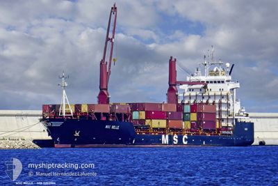
MSC BELLE
Container Ship
Current Trip
| Time Travelled | 1 day |
|---|---|
| Remaining Time | --- |
| Distance Travelled | 402.95 nm |
| Remaining Distance | --- |
| AVG Speed | 11 Noeuds |
| MAX Speed | 11.9 Noeuds |
| AVG Wind | 5.2 knots |
| MAX Wind | 20.2 knots |
| MIN Temp | 11.6°C / 52.88°F |
| MAX Temp | 18.1°C / 64.58°F |
| Tirant d eau | 9.9 m |
| Position reçue | 1 d depuis |
Current Position
| Longitude | --- |
|---|---|
| Latitude | --- |
| Etat | Under way using engine |
| Vitesse | 11.2 Noeuds |
| Parcours | 140° |
| Zone | Aegean Sea |
| Station | T-AIS |
| Position reçue | 1 d depuis |
Info
Information
The current position of MSC BELLE is in Aegean Sea with coordinates 35.66883° / 26.15333° as reported on 2025-12-07 11:44 by AIS to our vessel tracker app. The vessel's current speed is 11.2 Noeuds and is heading at the port of KALI LIMENES. The estimated time of arrival as calculated by MyShipTracking vessel tracking app is 2025-12-08 03:00 LT
The vessel MSC BELLE (IMO: 9203904, MMSI: 371743000) is a Container Ship that was built in 1998 ( 27 Age ). It's sailing under the flag of [PA] Panama.
In this page you can find informations about the vessels current position, last detected port calls, and current voyage information. If the vessels is not in coverage by AIS you will find the latest position.
The current position of MSC BELLE is detected by our AIS receivers and we are not responsible for the reliability of the data. The last position was recorded while the vessel was in Coverage by the Ais receivers of our vessel tracking app.
The current draught of MSC BELLE as reported by AIS is 9.9 meters
Weather
| Temperature | 18.1°C / 64.58°F |
|---|---|
| Wind Speed | 20 knots |
| Direction | 357° N |
| Pressure | 1011.9 hPa |
| Humidity | 65.5 % |
| Cloud Coverage | 89 % |
Featured Company
Last Port Calls
| Port | Arrival | Departure | Time In Port |
|---|---|---|---|
| 2025-12-06 07:12 | 2025-12-06 16:29 | 9 h | |
| 2025-12-04 07:41 | 2025-12-05 09:42 | 1 d | |
| 2025-12-01 22:19 | 2025-12-02 02:48 | 4 h | |
| 2025-11-30 23:38 | 2025-12-01 12:04 | 12 h | |
| 2025-11-27 17:22 | 2025-11-28 21:49 | 1 d | |
| 2025-11-24 14:13 | |||
| 2025-11-23 18:27 | 2025-11-23 18:48 | 21 m | |
| 2025-11-22 01:51 | |||
| 2025-11-22 01:35 | 2025-11-22 01:40 | 5 m | |
| 2025-11-22 00:38 |
Most Visited Ports (Last year)
| Port | Arrivals | |
|---|---|---|
| 16 | ||
| 16 | ||
| 16 | ||
| 11 | ||
| 10 | ||
| 8 |
Last Trips
| Origin | Departure | Destination | Arrival | Distance | |
|---|---|---|---|---|---|
| 2025-12-05 09:42 | 2025-12-06 07:12 | 198.85 nm | |||
| 2025-12-02 02:48 | 2025-12-04 07:41 | 398.17 nm | |||
| 2025-12-01 12:04 | 2025-12-01 22:19 | 99.87 nm | |||
| 2025-11-28 21:49 | 2025-11-30 23:38 | 278.35 nm | |||
| 2025-11-24 14:13 | 2025-11-27 17:22 | 529.65 nm | |||
| 2025-11-22 00:38 | 2025-11-23 18:27 | 371.48 nm | |||
| 2025-11-22 01:40 | 2025-11-22 01:51 | 4.88 nm | |||
| 2025-11-14 14:06 | 2025-11-22 01:35 | 1487.56 nm | |||
| 2025-11-11 13:56 | 2025-11-13 15:11 | 110.37 nm | |||
| 2025-11-08 09:20 | 2025-11-10 21:38 | 673.92 nm |
Events
| Heure | Evenement | Détails | Position/ Destination | Info |
|---|---|---|---|---|
| 2025-12-08 10:09 | Démarrage | 1.9 nm, East of KALI LIMENES |
34.92166 / 24.83967
GRKLL
|
Vitesse: 4.7 kn Parcours: 160° |
| 2025-12-08 01:13 | Arret | 1.9 nm, East of KALI LIMENES |
34.92533 / 24.84067
GRKLL
|
Vitesse: 0.2 kn Parcours: 61° |
| 2025-12-07 11:45 | Etat Changé | Default Under way using engine |
35.66600 / 26.15616
GRKLL
|
Vitesse: 11.2 kn Parcours: 140° |
| 2025-12-07 11:44 | Hors de la zone couverte |
35.66883 / 26.15333
Aegean Sea
GRKLL
|
Vitesse: 11.2 kn Parcours: 140° |
|
| 2025-12-07 04:41 | Etat Changé | Under way using engine Default |
36.93833 / 26.22633
GRKLL
|
Vitesse: 10.6 kn Parcours: 154° |
| 2025-12-07 04:33 | Etat Changé | Default Under way using engine |
36.95917 / 26.21433
GRKLL
|
Vitesse: 10.5 kn Parcours: 156° |
| 2025-12-07 00:13 | Etat Changé | Under way using engine Default |
37.66417 / 25.82017
GRKLL
|
Vitesse: 10.9 kn Parcours: 175° |
| 2025-12-06 23:53 | Etat Changé | Default Under way using engine |
37.72550 / 25.81383
GRKLL
|
Vitesse: 11.2 kn Parcours: 174° |
| 2025-12-06 23:07 | Changement de destination | GRKLL ALIAGA |
37.86617 / 25.77733
GRKLL
|
Vitesse: 11.3 kn Parcours: 166° |
| 2025-12-06 23:07 | Changement d'ETA | 2025/12/08 01:00 2025/12/06 03:30 |
37.86617 / 25.77733
GRKLL
|
Vitesse: 11.3 kn Parcours: 166° |