
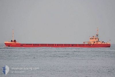
BLUE STAR
General Cargo
Current Trip
| Time Travelled | 16 days |
|---|---|
| Remaining Time | --- |
| Distance Travelled | 98.35 nm |
| Remaining Distance | --- |
| AVG Speed | 7.7 Noeuds |
| MAX Speed | 14.8 Noeuds |
| AVG Wind | 7.4 knots |
| MAX Wind | 15.7 knots |
| MIN Temp | 9.5°C / 49.1°F |
| MAX Temp | 23.8°C / 74.84°F |
| Tirant d eau | 2.6 m |
| Position reçue | 6 d depuis |
Current Position
| Longitude | 28.90562° |
|---|---|
| Latitude | 40.97337° |
| Etat | At anchor |
| Vitesse | 0.5 Noeuds |
| Parcours | 15° |
| Zone | Sea of Marmara |
| Station | T-AIS |
| Position reçue | 6 d depuis |
Info
Information
The current position of BLUE STAR is in Sea of Marmara with coordinates 40.97337° / 28.90562° as reported on 2024-05-22 13:20 by AIS to our vessel tracker app. The vessel's current speed is 0.5 Noeuds
The vessel BLUE STAR (IMO: 8421705, MMSI: 373016000) is a General Cargo that was built in 1986 ( 38 Age ). It's sailing under the flag of [PA] Panama.
In this page you can find informations about the vessels current position, last detected port calls, and current voyage information. If the vessels is not in coverage by AIS you will find the latest position.
The current position of BLUE STAR is detected by our AIS receivers and we are not responsible for the reliability of the data. The last position was recorded while the vessel was in Coverage by the Ais receivers of our vessel tracking app.
The current draught of BLUE STAR as reported by AIS is 2.6 meters
Weather
| Temperature | 23.2°C / 73.76°F |
|---|---|
| Wind Speed | 3 knots |
| Direction | 11° N |
| Pressure | 1010.5 hPa |
| Humidity | 50.3 % |
| Cloud Coverage | --- |
Featured Company
Last Port Calls
| Port | Arrival | Departure | Time In Port |
|---|---|---|---|
| 2024-05-09 19:47 | 2024-05-11 20:57 | 2 d | |
| 2024-04-28 10:18 | 2024-05-02 14:20 | 4 d | |
| 2024-04-17 16:18 | 2024-04-19 15:49 | 1 d | |
| 2024-04-03 11:06 | 2024-04-08 06:36 | 4 d | |
| 2024-03-08 09:26 | 2024-04-01 04:37 | 23 d | |
| 2024-03-05 16:03 | 2024-03-08 06:50 | 2 d |
Last Trips
| Origin | Departure | Destination | Arrival | Distance | |
|---|---|---|---|---|---|
| 2024-05-02 17:20 | 2024-05-09 22:47 | 379.31 nm | |||
| 2024-04-19 18:49 | 2024-04-28 13:18 | 365.71 nm | |||
| 2024-04-08 09:36 | 2024-04-17 19:18 | 300.10 nm | |||
| 2024-04-01 07:37 | 2024-04-03 14:06 | 164.80 nm | |||
| 2024-03-08 08:50 | 2024-03-08 11:26 | 19.02 nm | |||
| 2024-02-26 11:19 | 2024-03-05 18:03 | 504.84 nm |
Events
| Heure | Evenement | Détails | Position/ Destination | Info |
|---|---|---|---|---|
| 2024-05-22 13:20 | Hors de la zone couverte |
40.97337 / 28.90562
Sea of Marmara
|
Vitesse: 0.5 kn Parcours: 334.1° |
|
| 2024-05-21 16:26 | Etat Changé | At anchor Default |
40.97344 / 28.90548
SULINA
|
Vitesse: Parcours: -1° |
| 2024-05-21 16:23 | Etat Changé | Default At anchor |
40.97333 / 28.90500
SULINA
|
Vitesse: 0.5 kn Parcours: 29° |
| 2024-05-21 12:41 | Etat Changé | At anchor Default |
40.97478 / 28.90656
SULINA
|
Vitesse: Parcours: -1° |
| 2024-05-21 12:35 | Etat Changé | Default At anchor |
40.97333 / 28.90500
SULINA
|
Vitesse: Parcours: 208° |
| 2024-05-21 00:38 | Etat Changé | At anchor Default |
40.97332 / 28.90565
SULINA
|
Vitesse: 0.1 kn Parcours: 47° |
| 2024-05-21 00:35 | Etat Changé | Default At anchor |
40.97335 / 28.90555
SULINA
|
Vitesse: 0.1 kn Parcours: 32° |
| 2024-05-20 21:26 | Arret | 0.67 nm, South East of ZEYTINBURNU |
40.97331 / 28.90550
SULINA
|
Vitesse: Parcours: 31° |
| 2024-05-20 21:26 | Démarrage | 0.78 nm, South East of ZEYTINBURNU |
40.97128 / 28.90677
SULINA
|
Vitesse: 14.8 kn Parcours: 115.1° |
| 2024-05-20 15:03 | Etat Changé | At anchor Under way using engine |
40.97334 / 28.90564
SULINA
|
Vitesse: 6.5 kn Parcours: 33.1° |