
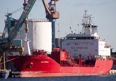
KILSTRAUM
Oil/Chemical Tanker
Current Trip
| Time Travelled | 3 h, 17 mins |
|---|---|
| Remaining Time | 2 days |
| Distance Travelled | 34.32 nm |
| Remaining Distance | 683.52 nm |
| AVG Speed | 10.6 Noeuds |
| MAX Speed | 14 Noeuds |
| AVG Wind | 11.8 knots |
| MAX Wind | 16 knots |
| MIN Temp | 11°C / 51.8°F |
| MAX Temp | 11.4°C / 52.52°F |
| Tirant d eau | 6.2 m |
| Position reçue | 1 m depuis |
Current Position
| Longitude | --- |
|---|---|
| Latitude | --- |
| Etat | Under way using engine |
| Vitesse | 13.8 Noeuds |
| Parcours | 285.3° |
| Zone | Irish Sea and St. George's Channel |
| Station | T-AIS |
| Position reçue | 1 m depuis |
Info
Information
The current position of KILSTRAUM is in Irish Sea and St. George's Channel with coordinates 53.55983° / -3.73665° as reported on 2025-12-08 14:31 by AIS to our vessel tracker app. The vessel's current speed is 13.8 Noeuds and is heading at the port of ROTTERDAM. The estimated time of arrival as calculated by MyShipTracking vessel tracking app is 2025-12-10 18:14 LT
The vessel KILSTRAUM (IMO: 9164732, MMSI: 257643000) is a Oil/Chemical Tanker that was built in 1999 ( 26 Age ). It's sailing under the flag of [NO] Norway.
In this page you can find informations about the vessels current position, last detected port calls, and current voyage information. If the vessels is not in coverage by AIS you will find the latest position.
The current position of KILSTRAUM is detected by our AIS receivers and we are not responsible for the reliability of the data. The last position was recorded while the vessel was in Coverage by the Ais receivers of our vessel tracking app.
The current draught of KILSTRAUM as reported by AIS is 6.2 meters
Weather
| Temperature | 11.4°C / 52.52°F |
|---|---|
| Wind Speed | 15 knots |
| Direction | 210° SSW |
| Pressure | 1001.8 hPa |
| Humidity | 78 % |
| Cloud Coverage | 10 % |
Featured Company
Last Port Calls
| Port | Arrival | Departure | Time In Port |
|---|---|---|---|
| 2025-12-08 10:26 | 2025-12-08 11:15 | 48 m | |
| 2025-12-08 09:32 | 2025-12-08 10:07 | 34 m | |
| 2025-12-06 13:00 | 2025-12-08 09:14 | 1 d | |
| 2025-11-27 10:15 | 2025-11-28 16:07 | 1 d | |
| 2025-11-22 10:41 | 2025-11-23 11:29 | 1 d | |
| 2025-11-16 03:41 | 2025-11-17 12:20 | 1 d | |
| 2025-11-12 09:04 | 2025-11-13 03:31 | 18 h | |
| 2025-11-08 00:10 | 2025-11-08 22:43 | 22 h | |
| 2025-11-04 12:54 | 2025-11-05 22:46 | 1 d | |
| 2025-11-01 05:44 | 2025-11-02 11:07 | 1 d |
Most Visited Ports (Last year)
| Port | Arrivals | |
|---|---|---|
| 14 | ||
| 10 | ||
| 9 | ||
| 9 | ||
| 5 | ||
| 5 |
Last Trips
| Origin | Departure | Destination | Arrival | Distance | |
|---|---|---|---|---|---|
| 2025-12-08 10:07 | 2025-12-08 10:26 | 1.91 nm | |||
| 2025-12-08 09:14 | 2025-12-08 09:32 | 2.13 nm | |||
| 2025-11-28 16:07 | 2025-12-06 13:00 | 1455.72 nm | |||
| 2025-11-23 11:29 | 2025-11-27 10:15 | 1094.94 nm | |||
| 2025-11-17 12:20 | 2025-11-22 10:41 | 1326.16 nm | |||
| 2025-11-13 03:31 | 2025-11-16 03:41 | 813.12 nm | |||
| 2025-11-08 22:43 | 2025-11-12 09:04 | 773.97 nm | |||
| 2025-11-05 22:46 | 2025-11-08 00:10 | 297.46 nm | |||
| 2025-11-02 11:07 | 2025-11-04 12:54 | 410.72 nm | |||
| 2025-10-30 08:51 | 2025-11-01 05:44 | 329.12 nm |
Events
| Heure | Evenement | Détails | Position/ Destination | Info |
|---|---|---|---|---|
| 2025-12-08 11:15 | PORT DE DEPART |
|
53.32869 / -2.95289
NLRTM
|
Vitesse: 7.1 kn Parcours: 331° |
| 2025-12-08 11:11 | Démarrage |
53.32297 / -2.94825
[GB] EASTHAM
|
Vitesse: 3.2 kn Parcours: 331° |
|
| 2025-12-08 10:38 | Arret |
53.32136 / -2.94681
[GB] EASTHAM
|
Vitesse: 0.3 kn Parcours: 333° |
|
| 2025-12-08 10:26 | Port d'arrivée |
|
53.31665 / -2.94164
[GB] EASTHAM
|
Vitesse: 3.8 kn Parcours: 320° |
| 2025-12-08 10:07 | PORT DE DEPART |
|
53.29624 / -2.90256
NLRTM
|
Vitesse: 6.1 kn Parcours: 313° |
| 2025-12-08 09:32 | Port d'arrivée |
|
53.29487 / -2.90041
[GB] ELLESMERE
|
Vitesse: 5.4 kn Parcours: 136.2° |
| 2025-12-08 09:14 | PORT DE DEPART |
|
53.31538 / -2.93989
NLRTM
|
Vitesse: 6.1 kn Parcours: 143° |
| 2025-12-08 09:12 | Démarrage |
53.31783 / -2.94325
[GB] EASTHAM
|
Vitesse: 3.3 kn Parcours: 139° |
|
| 2025-12-08 09:08 | Etat Changé | Under way using engine Moored |
53.31855 / -2.94432
[GB] EASTHAM
|
Vitesse: 0.1 kn Parcours: 146° |
| 2025-12-08 09:08 | Etat Changé | Moored Default |
53.31853 / -2.94435
[GB] EASTHAM
|
Vitesse: Parcours: 146° |