
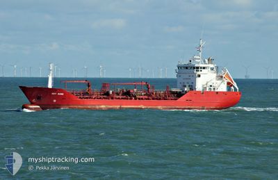
KEY SUND
Oil/Chemical Tanker
Current Trip
| Time Travelled | 1 day |
|---|---|
| Remaining Time | 1 h, 28 mins |
| Distance Travelled | 503.85 nm |
| Remaining Distance | 20.16 nm |
| AVG Speed | 11.6 Noeuds |
| MAX Speed | 13.5 Noeuds |
| AVG Wind | 7.1 knots |
| MAX Wind | 14.9 knots |
| MIN Temp | 9.4°C / 48.92°F |
| MAX Temp | 12.8°C / 55.04°F |
| Tirant d eau | 5.7 m |
| Position reçue | 1 m depuis |
Current Position
| Longitude | 3.76412° |
|---|---|
| Latitude | 52.13444° |
| Etat | Under way using engine |
| Vitesse | 11.3 Noeuds |
| Parcours | 178.7° |
| Zone | North Sea |
| Station | T-AIS |
| Position reçue | 1 m depuis |
Info
Information
The current position of KEY SUND is in North Sea with coordinates 52.13444° / 3.76412° as reported on 2024-05-06 20:13 by AIS to our vessel tracker app. The vessel's current speed is 11.3 Noeuds and is heading at the port of ROTTERDAM. The estimated time of arrival as calculated by MyShipTracking vessel tracking app is 2024-05-06 21:42 LT
The vessel KEY SUND (IMO: 8920567, MMSI: 259360000) is a Oil/Chemical Tanker that was built in 1993 ( 31 Age ). It's sailing under the flag of [NO] Norway.
In this page you can find informations about the vessels current position, last detected port calls, and current voyage information. If the vessels is not in coverage by AIS you will find the latest position.
The current position of KEY SUND is detected by our AIS receivers and we are not responsible for the reliability of the data. The last position was recorded while the vessel was in Coverage by the Ais receivers of our vessel tracking app.
The current draught of KEY SUND as reported by AIS is 5.7 meters
Weather
| Temperature | 12.5°C / 54.5°F |
|---|---|
| Wind Speed | 14 knots |
| Direction | 50° NE |
| Pressure | 1011.3 hPa |
| Humidity | 84.6 % |
| Cloud Coverage | 100 % |
Featured Company
Last Port Calls
| Port | Arrival | Departure | Time In Port |
|---|---|---|---|
| 2024-05-03 22:18 | 2024-05-05 03:12 | 1 d | |
| 2024-04-29 13:30 | 2024-04-30 13:45 | 1 d | |
| 2024-04-25 15:19 | 2024-04-27 04:10 | 1 d | |
| 2024-04-22 05:45 | 2024-04-22 07:08 | 1 h | |
| 2024-04-21 18:55 | 2024-04-22 05:15 | 10 h | |
| 2024-04-14 08:09 | 2024-04-14 19:13 | 11 h | |
| 2024-04-12 22:12 | 2024-04-13 13:27 | 15 h | |
| 2024-04-10 03:24 | 2024-04-10 14:33 | 11 h | |
| 2024-04-09 04:55 | 2024-04-09 18:35 | 13 h | |
| 2024-04-08 01:11 | 2024-04-08 03:01 | 1 h |
Last Trips
| Origin | Departure | Destination | Arrival | Distance | |
|---|---|---|---|---|---|
| 2024-04-30 14:45 | 2024-05-04 00:18 | 979.10 nm | |||
| 2024-04-27 06:10 | 2024-04-29 14:30 | 710.99 nm | |||
| 2024-04-22 09:08 | 2024-04-25 17:19 | 544.01 nm | |||
| 2024-04-22 07:15 | 2024-04-22 07:45 | 3.19 nm | |||
| 2024-04-14 20:13 | 2024-04-21 20:55 | 1364.02 nm | |||
| 2024-04-13 14:27 | 2024-04-14 09:09 | 170.50 nm | |||
| 2024-04-10 16:33 | 2024-04-12 23:12 | 520.12 nm | |||
| 2024-04-09 20:35 | 2024-04-10 05:24 | 98.94 nm | |||
| 2024-04-08 05:01 | 2024-04-09 06:55 | 301.23 nm | |||
| 2024-04-08 02:47 | 2024-04-08 03:11 | 3.10 nm |
Events
| Heure | Evenement | Détails | Position/ Destination | Info |
|---|---|---|---|---|
| 2024-05-06 19:26 | Changement d'ETA | 2024/05/06 21:00 2024/05/06 20:00 |
52.29986 / 3.78326
NO SPG>NL RTM
|
Vitesse: 11.9 kn Parcours: 191.6° |
| 2024-05-06 18:56 | Etat Changé | Under way using engine Default |
52.38208 / 3.81131
NO SPG>NL RTM
|
Vitesse: 12.3 kn Parcours: 191° |
| 2024-05-06 18:15 | Etat Changé | Default Under way using engine |
52.52061 / 3.85896
NO SPG>NL RTM
|
Vitesse: 12.6 kn Parcours: 192.2° |
| 2024-05-06 18:10 | Etat Changé | Under way using engine Default |
52.53827 / 3.86532
NO SPG>NL RTM
|
Vitesse: 12.7 kn Parcours: 193° |
| 2024-05-06 17:51 | Dans la zone couverte |
52.53827 / 3.86532
North Sea
NO SPG>NL RTM
|
Vitesse: 12.6 kn Parcours: 191.7° |
|
| 2024-05-06 15:19 | Etat Changé | Default Under way using engine |
53.06045 / 4.20580
NO SPG>NL RTM
|
Vitesse: 11.3 kn Parcours: 228.2° |
| 2024-05-06 15:13 | Hors de la zone couverte |
53.07189 / 4.22778
North Sea
NO SPG>NL RTM
|
Vitesse: 11.3 kn Parcours: 228.2° |
|
| 2024-05-06 12:48 | Etat Changé | Under way using engine Default |
53.47001 / 4.56492
NO SPG>NL RTM
|
Vitesse: 13.1 kn Parcours: 199° |
| 2024-05-06 12:36 | Etat Changé | Default Under way using engine |
53.51277 / 4.58841
NO SPG>NL RTM
|
Vitesse: 13.1 kn Parcours: 199.1° |
| 2024-05-06 12:36 | Detecté en mer | Dutch part of the North Sea |
53.51277 / 4.58841
North Sea
NO SPG>NL RTM
|
Vitesse: 13.1 kn Parcours: 199.1° |