
HARVEST RAIN
Cargo
Current Trip
| Trip Time | --- |
|---|---|
| Trip Distance | --- |
| AVG Speed | --- |
| MAX Speed | --- |
| Tirant d eau | --- |
| AVG Wind | --- |
| MAX Wind | --- |
| MIN Temp | --- |
| MAX Temp | --- |
| Position reçue | 8 d depuis |
Current Position
| Longitude | 14.55255° |
|---|---|
| Latitude | 45.27134° |
| Etat | Under way using engine |
| Vitesse | 5.8 Noeuds |
| Parcours | 40° |
| Zone | Adriatic Sea |
| Station | T-AIS |
| Position reçue | 8 d depuis |
Info
Information
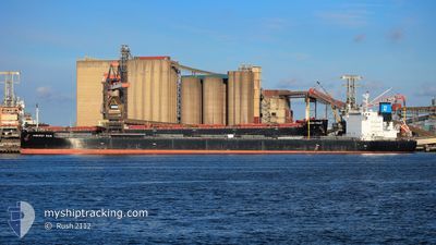
The current position of HARVEST RAIN is in Adriatic Sea with coordinates 45.27134° / 14.55255° as reported on 2024-04-18 14:02 by AIS to our vessel tracker app. The vessel's current speed is 5.8 Noeuds and is currently inside the port of BAKAR.
The vessel HARVEST RAIN (IMO: 9643893, MMSI: 538006315) is a Cargo It's sailing under the flag of [MH] Marshall Is.
In this page you can find informations about the vessels current position, last detected port calls, and current voyage information. If the vessels is not in coverage by AIS you will find the latest position.
The current position of HARVEST RAIN is detected by our AIS receivers and we are not responsible for the reliability of the data. The last position was recorded while the vessel was in Coverage by the Ais receivers of our vessel tracking app.
The current draught of HARVEST RAIN as reported by AIS is 13.7 meters
Weather
| Temperature | 9.1°C / 48.38°F |
|---|---|
| Wind Speed | 4 knots |
| Direction | 54° NE |
| Pressure | 1015.1 hPa |
| Humidity | 74.4 % |
| Cloud Coverage | 40 % |
Featured Company
Last Port Calls
| Port | Arrival | Departure | Time In Port |
|---|---|---|---|
| 2024-03-23 21:19 | 2024-03-26 17:41 | 2 d | |
| 2024-02-14 14:22 | 2024-02-19 04:28 | 4 d |
Most Visited Ports (Last year)
| Port | Arrivals | |
|---|---|---|
| 1 | ||
| 1 | ||
| 1 | ||
| 1 | ||
| 1 | ||
| 1 |
Last Trips
| Origin | Departure | Destination | Arrival | Distance | |
|---|---|---|---|---|---|
| 2024-02-19 07:28 | 2024-03-23 17:19 | 5817.43 nm | |||
| 2024-01-18 22:07 | 2024-02-14 17:22 | 6206.08 nm |
Events
| Heure | Evenement | Détails | Position/ Destination | Info |
|---|---|---|---|---|
| 2024-04-18 14:02 | Hors de la zone couverte |
45.27134 / 14.55255
Adriatic Sea
|
Vitesse: 5.8 kn Parcours: 40° |
|
| 2024-04-18 12:52 | Démarrage | 3.85 nm, South of RIJEKA |
45.26568 / 14.44268
HR BAK
|
Vitesse: 3.3 kn Parcours: 115° |
| 2024-04-18 12:38 | Etat Changé | Under way using engine At anchor |
45.26792 / 14.43573
HR BAK
|
Vitesse: 0.2 kn Parcours: 121° |
| 2024-04-18 04:28 | Etat Changé | At anchor Default |
45.26895 / 14.43630
HR BAK
|
Vitesse: 0.1 kn Parcours: 98° |
| 2024-04-18 04:22 | Etat Changé | Default At anchor |
45.26907 / 14.43637
HR BAK
|
Vitesse: 0.1 kn Parcours: 99° |
| 2024-04-18 04:19 | Etat Changé | At anchor Default |
45.26913 / 14.43641
HR BAK
|
Vitesse: 0.1 kn Parcours: 100° |
| 2024-04-18 04:16 | Etat Changé | Default At anchor |
45.26917 / 14.43645
HR BAK
|
Vitesse: 0.1 kn Parcours: 102° |
| 2024-04-18 03:55 | Etat Changé | At anchor Default |
45.26949 / 14.43660
HR BAK
|
Vitesse: 0.1 kn Parcours: 111° |
| 2024-04-18 03:43 | Etat Changé | Default At anchor |
45.26956 / 14.43670
HR BAK
|
Vitesse: Parcours: 113° |
| 2024-04-18 03:34 | Etat Changé | At anchor Default |
45.26961 / 14.43672
HR BAK
|
Vitesse: Parcours: 113° |