
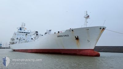
GREEN CHILE
Reefer
Current Trip
| Time Travelled | 4 days |
|---|---|
| Remaining Time | 3 h, 48 mins |
| Distance Travelled | 1779.87 nm |
| Remaining Distance | 107.21 nm |
| AVG Speed | 16.6 Noeuds |
| MAX Speed | 19.7 Noeuds |
| AVG Wind | 9.5 knots |
| MAX Wind | 19 knots |
| MIN Temp | 17.5°C / 63.5°F |
| MAX Temp | 29.5°C / 85.1°F |
| Tirant d eau | 7 m |
| Position reçue | 4 d depuis |
Current Position
| Longitude | 134.93045° |
|---|---|
| Latitude | 33.97586° |
| Etat | Under way using engine |
| Vitesse | 17.7 Noeuds |
| Parcours | 186° |
| Zone | Philippine Sea |
| Station | T-AIS |
| Position reçue | 4 d depuis |
Info
Information
The current position of GREEN CHILE is in Philippine Sea with coordinates 33.97586° / 134.93045° as reported on 2024-04-25 12:52 by AIS to our vessel tracker app. The vessel's current speed is 17.7 Noeuds and is heading at the port of DAVAO. The estimated time of arrival as calculated by MyShipTracking vessel tracking app is 2024-04-29 23:19 LT
The vessel GREEN CHILE (IMO: 8912156, MMSI: 311051000) is a Reefer that was built in 1992 ( 32 Age ). It's sailing under the flag of [BS] Bahamas.
In this page you can find informations about the vessels current position, last detected port calls, and current voyage information. If the vessels is not in coverage by AIS you will find the latest position.
The current position of GREEN CHILE is detected by our AIS receivers and we are not responsible for the reliability of the data. The last position was recorded while the vessel was in Coverage by the Ais receivers of our vessel tracking app.
The current draught of GREEN CHILE as reported by AIS is 7 meters
Weather
| Temperature | 27.5°C / 81.5°F |
|---|---|
| Wind Speed | 16 knots |
| Direction | 40° NE |
| Pressure | 1007 hPa |
| Humidity | 84.4 % |
| Cloud Coverage | 100 % |
Featured Company
Last Port Calls
| Port | Arrival | Departure | Time In Port |
|---|---|---|---|
| 2024-04-24 22:13 | 2024-04-25 09:58 | 11 h | |
| 2024-04-21 22:08 | 2024-04-23 20:55 | 1 d | |
| 2024-04-07 01:27 | 2024-04-09 00:31 | 1 d | |
| 2024-04-02 06:21 | 2024-04-05 07:26 | 3 d | |
| 2024-03-10 07:05 | 2024-03-10 16:00 | 8 h | |
| 2024-03-03 18:29 | 2024-03-08 10:57 | 4 d |
Most Visited Ports (Last year)
| Port | Arrivals | |
|---|---|---|
| 3 | ||
| 3 | ||
| 3 | ||
| 2 | ||
| 1 | ||
| 1 |
Last Trips
| Origin | Departure | Destination | Arrival | Distance | |
|---|---|---|---|---|---|
| 2024-04-24 05:55 | 2024-04-25 07:13 | 366.02 nm | |||
| 2024-04-09 09:31 | 2024-04-22 07:08 | 3878.02 nm | |||
| 2024-04-05 16:26 | 2024-04-07 10:27 | 366.62 nm | |||
| 2024-03-08 13:57 | 2024-04-02 15:21 | 8427.21 nm | |||
| 2024-03-08 13:57 | 2024-03-10 09:05 | 404.51 nm | |||
| 2024-01-31 19:51 | 2024-03-03 21:29 | 3366.09 nm |
Events
| Heure | Evenement | Détails | Position/ Destination | Info |
|---|---|---|---|---|
| 2024-04-25 13:00 | Etat Changé | Default Under way using engine |
33.93383 / 134.92517
PHDVO
|
Vitesse: 17.7 kn Parcours: 186° |
| 2024-04-25 12:52 | Etat Changé | Under way using engine Default |
33.97586 / 134.93045
PHDVO
|
Vitesse: 17.9 kn Parcours: 186° |
| 2024-04-25 12:52 | Hors de la zone couverte |
33.97586 / 134.93045
Philippine Sea
PHDVO
|
Vitesse: 17.7 kn Parcours: 186° |
|
| 2024-04-25 12:44 | Etat Changé | Default Under way using engine |
34.01320 / 134.93324
PHDVO
|
Vitesse: 17.6 kn Parcours: 188.7° |
| 2024-04-25 12:13 | Etat Changé | Under way using engine Default |
34.16514 / 134.95612
PHDVO
|
Vitesse: 17.5 kn Parcours: 188° |
| 2024-04-25 12:12 | Etat Changé | Default Under way using engine |
34.16943 / 134.95680
PHDVO
|
Vitesse: 17.3 kn Parcours: 188.9° |
| 2024-04-25 11:52 | Changement de destination | PHDVO JP UKB |
34.26223 / 134.97305
PHDVO
|
Vitesse: 14.7 kn Parcours: 177.3° |
| 2024-04-25 11:52 | Changement d'ETA | 2024/04/29 22:00 2024/04/24 21:45 |
34.26223 / 134.97305
PHDVO
|
Vitesse: 14.7 kn Parcours: 177.3° |
| 2024-04-25 11:50 | Changement de zone | Japanese part of the Philippine Sea Japanese part of the Inland Sea |
34.26973 / 134.97258
Philippine Sea
|
Vitesse: 13.9 kn Parcours: 177.5° |
| 2024-04-25 09:58 | PORT DE DEPART |
|
34.64784 / 135.26619
JP UKB
|
Vitesse: 12 kn Parcours: 148° |