
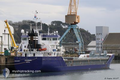
CEDERBORG
General Cargo
Current Trip
| Time Travelled | 8 days |
|---|---|
| Remaining Time | --- |
| Distance Travelled | 2114.02 nm |
| Remaining Distance | --- |
| AVG Speed | 10.8 Noeuds |
| MAX Speed | 14.8 Noeuds |
| AVG Wind | 12.1 knots |
| MAX Wind | 31 knots |
| MIN Temp | 12.7°C / 54.86°F |
| MAX Temp | 20.6°C / 69.08°F |
| Tirant d eau | 6.3 m |
| Position reçue | Maintenant |
Current Position
| Longitude | -9.83722° |
|---|---|
| Latitude | 38.99775° |
| Etat | Under way using engine |
| Vitesse | 10.2 Noeuds |
| Parcours | 0.3° |
| Zone | North Atlantic Ocean |
| Station | T-AIS |
| Position reçue | Maintenant |
Info
Information
The current position of CEDERBORG is in North Atlantic Ocean with coordinates 38.99775° / -9.83722° as reported on 2024-05-02 21:55 by AIS to our vessel tracker app. The vessel's current speed is 10.2 Noeuds and is heading at the port of ELLESMERE. The estimated time of arrival as calculated by MyShipTracking vessel tracking app is 2024-05-06 18:00 LT
The vessel CEDERBORG (IMO: 9356567, MMSI: 246782000) is a General Cargo that was built in 2011 ( 13 Age ). It's sailing under the flag of [NL] Netherlands.
In this page you can find informations about the vessels current position, last detected port calls, and current voyage information. If the vessels is not in coverage by AIS you will find the latest position.
The current position of CEDERBORG is detected by our AIS receivers and we are not responsible for the reliability of the data. The last position was recorded while the vessel was in Coverage by the Ais receivers of our vessel tracking app.
The current draught of CEDERBORG as reported by AIS is 6.3 meters
Weather
| Temperature | 15.1°C / 59.18°F |
|---|---|
| Wind Speed | 12 knots |
| Direction | 278° W |
| Pressure | 1021.3 hPa |
| Humidity | 62.7 % |
| Cloud Coverage | 78 % |
Featured Company
Last Port Calls
| Port | Arrival | Departure | Time In Port |
|---|---|---|---|
| 2024-04-19 13:26 | 2024-04-24 14:02 | 5 d | |
| 2024-03-28 07:12 | 2024-04-16 06:57 | 18 d | |
| 2024-03-27 07:55 | 2024-03-28 03:29 | 19 h | |
| 2024-03-22 07:00 | 2024-03-22 22:13 | 15 h | |
| 2024-03-17 10:34 | 2024-03-18 14:11 | 1 d | |
| 2024-03-04 03:17 |
Last Trips
| Origin | Departure | Destination | Arrival | Distance | |
|---|---|---|---|---|---|
| 2024-04-16 09:57 | 2024-04-19 16:26 | 87.03 nm | |||
| 2024-03-28 06:29 | 2024-03-28 10:12 | 30.77 nm | |||
| 2024-03-23 01:13 | 2024-03-27 10:55 | 90.63 nm | |||
| 2024-03-18 15:11 | 2024-03-22 10:00 | 972.21 nm | |||
| 2024-03-04 04:17 | 2024-03-17 11:34 | 2492.75 nm |
Events
| Heure | Evenement | Détails | Position/ Destination | Info |
|---|---|---|---|---|
| 2024-05-02 13:56 | Etat Changé | Under way using engine Default |
37.61279 / -9.51352
ELLESMERE
|
Vitesse: 10.6 kn Parcours: 345° |
| 2024-05-02 13:56 | Dans la zone couverte |
37.62145 / -9.51607
North Atlantic Ocean
ELLESMERE
|
Vitesse: 10.8 kn Parcours: 347.8° |
|
| 2024-05-02 12:30 | Etat Changé | Default Under way using engine |
37.36983 / -9.43958
ELLESMERE
|
Vitesse: 10.8 kn Parcours: 346.4° |
| 2024-05-02 12:30 | Etat Changé | Under way using engine Default |
37.36827 / -9.43912
ELLESMERE
|
Vitesse: 11 kn Parcours: 347° |
| 2024-05-02 12:30 | Dans la zone couverte |
37.36827 / -9.43912
North Atlantic Ocean
ELLESMERE
|
Vitesse: 10.8 kn Parcours: 346.4° |
|
| 2024-05-02 12:30 | Hors de la zone couverte |
37.36827 / -9.43912
North Atlantic Ocean
ELLESMERE
|
Vitesse: 10.8 kn Parcours: 346.4° |
|
| 2024-05-02 11:14 | Etat Changé | Default Under way using engine |
37.14772 / -9.37229
ELLESMERE
|
Vitesse: 10.5 kn Parcours: 346° |
| 2024-05-02 11:09 | Etat Changé | Under way using engine Default |
37.13088 / -9.36732
ELLESMERE
|
Vitesse: 10.7 kn Parcours: 347° |
| 2024-05-02 11:09 | Hors de la zone couverte |
37.13088 / -9.36732
North Atlantic Ocean
ELLESMERE
|
Vitesse: 10.5 kn Parcours: 346° |
|
| 2024-05-02 10:58 | Dans la zone couverte |
37.13088 / -9.36732
North Atlantic Ocean
ELLESMERE
|
Vitesse: 10.5 kn Parcours: 346° |