
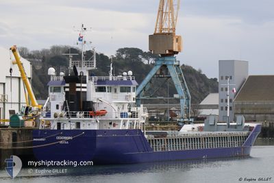
CEDERBORG
General Cargo
Current Trip
| Time Travelled | 16 h, 26 mins |
|---|---|
| Remaining Time | --- |
| Distance Travelled | 192.76 nm |
| Remaining Distance | --- |
| AVG Speed | 12.3 Knots |
| MAX Speed | 14.8 Knots |
| AVG Wind | 4.4 knots |
| MAX Wind | 13.3 knots |
| MIN Temp | 15.5°C / 59.9°F |
| MAX Temp | 20.6°C / 69.08°F |
| Draught | 6.3 m |
| Position Received | 1 m ago |
Current Position
| Longitude | 25.32074° |
|---|---|
| Latitude | 39.05171° |
| Status | Under way using engine |
| Speed | 10.6 Knots |
| Course | 209.6° |
| Area | Aegean Sea |
| Station | T-AIS |
| Position Received | 1 m ago |
Info
Information
The current position of CEDERBORG is in Aegean Sea with coordinates 39.05171° / 25.32074° as reported on 2024-04-25 06:26 by AIS to our vessel tracker app. The vessel's current speed is 10.6 Knots and is heading at the port of ELLESMERE. The estimated time of arrival as calculated by MyShipTracking vessel tracking app is 2024-05-07 12:00 LT
The vessel CEDERBORG (IMO: 9356567, MMSI: 246782000) is a General Cargo that was built in 2011 ( 13 years old ). It's sailing under the flag of [NL] Netherlands.
In this page you can find informations about the vessels current position, last detected port calls, and current voyage information. If the vessels is not in coverage by AIS you will find the latest position.
The current position of CEDERBORG is detected by our AIS receivers and we are not responsible for the reliability of the data. The last position was recorded while the vessel was in Coverage by the Ais receivers of our vessel tracking app.
The current draught of CEDERBORG as reported by AIS is 6.3 meters
Weather
| Temperature | 17.6°C / 63.68°F |
|---|---|
| Wind Speed | 13 knots |
| Direction | 171° S |
| Pressure | 1004.1 hPa |
| Humidity | 90 % |
| Cloud Coverage | 100 % |
Featured Company
Last Port Calls
| Port | Arrival | Departure | Time In Port |
|---|---|---|---|
| 2024-04-19 13:26 | 2024-04-24 14:02 | 5 d | |
| 2024-03-28 07:12 | 2024-04-16 06:57 | 18 d | |
| 2024-03-27 07:55 | 2024-03-28 03:29 | 19 h | |
| 2024-03-22 07:00 | 2024-03-22 22:13 | 15 h | |
| 2024-03-17 10:34 | 2024-03-18 14:11 | 1 d | |
| 2024-02-28 07:27 | 2024-03-04 03:17 | 4 d | |
| 2024-02-22 00:43 | 2024-02-23 17:43 | 1 d | |
| 2024-02-21 05:18 | 2024-02-21 05:20 | 1 m | |
| 2024-02-15 12:17 | 2024-02-16 18:41 | 1 d | |
| 2024-02-13 13:55 | 2024-02-14 18:29 | 1 d |
Last Trips
| Origin | Departure | Destination | Arrival | Distance | |
|---|---|---|---|---|---|
| 2024-04-16 09:57 | 2024-04-19 16:26 | 87.03 nm | |||
| 2024-03-28 06:29 | 2024-03-28 10:12 | 30.77 nm | |||
| 2024-03-23 01:13 | 2024-03-27 10:55 | 90.63 nm | |||
| 2024-03-18 15:11 | 2024-03-22 10:00 | 972.21 nm | |||
| 2024-03-04 04:17 | 2024-03-17 11:34 | 2492.75 nm | |||
| 2024-02-23 18:43 | 2024-02-28 08:27 | 735.58 nm | |||
| 2024-02-21 06:20 | 2024-02-22 01:43 | 215.79 nm | |||
| 2024-02-16 19:41 | 2024-02-21 06:18 | 1178.72 nm | |||
| 2024-02-14 18:29 | 2024-02-15 13:17 | 114.51 nm | |||
| 2024-02-09 21:14 | 2024-02-13 13:55 | 942.11 nm |
Events
| Time | Event | Details | Position / Dest | Info |
|---|---|---|---|---|
| 2024-04-25 01:44 | Detected in Sea | Greek part of the Aegean Sea |
39.84523 / 25.86585
Aegean Sea
ELLESMERE
|
Speed: 11.6 kn Course: 205.5° |
| 2024-04-25 01:21 | Status Changed | Under way using engine Default |
39.91199 / 25.90989
ELLESMERE
|
Speed: 11.7 kn Course: 208° |
| 2024-04-25 00:53 | Status Changed | Default Under way using engine |
39.98974 / 25.96921
ELLESMERE
|
Speed: 11.6 kn Course: 231.4° |
| 2024-04-25 00:49 | Status Changed | Under way using engine Default |
39.99737 / 25.98097
ELLESMERE
|
Speed: 12 kn Course: 258° |
| 2024-04-25 00:20 | Status Changed | Default Under way using engine |
40.01752 / 26.10289
ELLESMERE
|
Speed: 12.8 kn Course: 260.5° |
| 2024-04-25 00:04 | Change Sea Area | Turkish part of the Aegean Sea Turkish part of the Sea of Marmara |
40.02539 / 26.17369
Aegean Sea
ELLESMERE
|
Speed: 11.4 kn Course: 262.5° |
| 2024-04-24 22:04 | Status Changed | Under way using engine Default |
40.30118 / 26.57323
ELLESMERE
|
Speed: 12.3 kn Course: 228° |
| 2024-04-24 21:49 | IN Coverage |
40.29970 / 26.57091
Sea of Marmara
ELLESMERE
|
Speed: 12.5 kn Course: 229.5° |
|
| 2024-04-24 19:39 | OUT of Coverage |
40.56634 / 27.07687
Sea of Marmara
ELLESMERE
|
Speed: 11.8 kn Course: 241.4° |
|
| 2024-04-24 14:02 | PORT DEPARTURE |
|
40.36167 / 27.95360
ELLESMERE
|
Speed: 6.9 kn Course: 340° |