
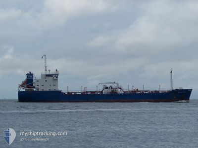
BITLAND
Asphalt/Bitumen Tanker
Current Trip
| Time Travelled | 22 h, 30 mins |
|---|---|
| Remaining Time | --- |
| Distance Travelled | 239.85 nm |
| Remaining Distance | --- |
| AVG Speed | 11.2 Noeuds |
| MAX Speed | 14.4 Noeuds |
| AVG Wind | 12.7 knots |
| MAX Wind | 28 knots |
| MIN Temp | 9.1°C / 48.38°F |
| MAX Temp | 11.7°C / 53.06°F |
| Tirant d eau | 5.5 m |
| Position reçue | 11 h, 35 m depuis |
Current Position
| Longitude | --- |
|---|---|
| Latitude | --- |
| Etat | Under way using engine |
| Vitesse | 8.1 Noeuds |
| Parcours | 197.9° |
| Zone | Irish Sea and St. George's Channel |
| Station | T-AIS |
| Position reçue | 11 h, 35 m depuis |
Info
Information
The current position of BITLAND is in Irish Sea and St. George's Channel with coordinates 52.80817° / -5.34374° as reported on 2025-12-12 01:39 by AIS to our vessel tracker app. The vessel's current speed is 8.1 Noeuds and is heading at the port of GOTEBORG. The estimated time of arrival as calculated by MyShipTracking vessel tracking app is 2025-12-15 23:00 LT
The vessel BITLAND (IMO: 9503914, MMSI: 244784000) is a Asphalt/Bitumen Tanker that was built in 2012 ( 13 Age ). It's sailing under the flag of [NL] Netherlands.
In this page you can find informations about the vessels current position, last detected port calls, and current voyage information. If the vessels is not in coverage by AIS you will find the latest position.
The current position of BITLAND is detected by our AIS receivers and we are not responsible for the reliability of the data. The last position was recorded while the vessel was in Coverage by the Ais receivers of our vessel tracking app.
The current draught of BITLAND as reported by AIS is 5.5 meters
Weather
| Temperature | 11.1°C / 51.98°F |
|---|---|
| Wind Speed | 13 knots |
| Direction | 246° WSW |
| Pressure | 1018.2 hPa |
| Humidity | 68.5 % |
| Cloud Coverage | 100 % |
Featured Company
Last Port Calls
| Port | Arrival | Departure | Time In Port |
|---|---|---|---|
| 2025-12-10 15:28 | 2025-12-11 14:44 | 23 h | |
| 2025-12-05 17:01 | 2025-12-06 23:33 | 1 d | |
| 2025-11-30 10:04 | 2025-12-01 07:15 | 21 h | |
| 2025-11-27 04:23 | 2025-11-28 05:17 | 1 d | |
| 2025-11-16 21:09 | 2025-11-19 09:25 | 2 d | |
| 2025-11-13 19:52 | 2025-11-14 20:54 | 1 d | |
| 2025-11-09 20:22 | 2025-11-10 14:45 | 18 h | |
| 2025-11-08 21:56 | 2025-11-09 04:32 | 6 h | |
| 2025-11-06 05:59 | 2025-11-06 19:25 | 13 h | |
| 2025-11-02 10:39 | 2025-11-03 02:24 | 15 h |
Last Trips
| Origin | Departure | Destination | Arrival | Distance | |
|---|---|---|---|---|---|
| 2025-12-06 23:33 | 2025-12-10 15:28 | 791.63 nm | |||
| 2025-12-01 07:15 | 2025-12-05 17:01 | 406.38 nm | |||
| 2025-11-28 05:17 | 2025-11-30 10:04 | 580.07 nm | |||
| 2025-11-19 09:25 | 2025-11-27 04:23 | 704.45 nm | |||
| 2025-11-14 20:54 | 2025-11-16 21:09 | 546.98 nm | |||
| 2025-11-10 14:45 | 2025-11-13 19:52 | 726.49 nm | |||
| 2025-11-09 04:32 | 2025-11-09 20:22 | 196.36 nm | |||
| 2025-11-06 19:25 | 2025-11-08 21:56 | 329.69 nm | |||
| 2025-11-03 02:24 | 2025-11-06 05:59 | 678.77 nm | |||
| 2025-11-01 06:16 | 2025-11-02 10:39 | 330.42 nm |
Events
| Heure | Evenement | Détails | Position/ Destination | Info |
|---|---|---|---|---|
| 2025-12-12 01:47 | Etat Changé | Default Under way using engine |
52.79163 / -5.35264
GB EAM > SE GOT
|
Vitesse: 8.1 kn Parcours: 197.9° |
| 2025-12-12 01:39 | Etat Changé | Under way using engine Default |
52.80817 / -5.34374
GB EAM > SE GOT
|
Vitesse: 8.3 kn Parcours: 195° |
| 2025-12-12 01:39 | Dans la zone couverte |
52.80817 / -5.34374
Irish Sea and St. George's Channel
GB EAM > SE GOT
|
Vitesse: 8.1 kn Parcours: 197.9° |
|
| 2025-12-12 01:39 | Hors de la zone couverte |
52.80817 / -5.34374
Irish Sea and St. George's Channel
GB EAM > SE GOT
|
Vitesse: 8.1 kn Parcours: 197.9° |
|
| 2025-12-12 00:39 | Etat Changé | Default Under way using engine |
52.94666 / -5.27017
GB EAM > SE GOT
|
Vitesse: 8.5 kn Parcours: 201.4° |
| 2025-12-12 00:33 | Hors de la zone couverte |
52.96174 / -5.26221
Irish Sea and St. George's Channel
GB EAM > SE GOT
|
Vitesse: 8.5 kn Parcours: 201.4° |
|
| 2025-12-12 00:28 | Etat Changé | Under way using engine Default |
52.97399 / -5.25563
GB EAM > SE GOT
|
Vitesse: 9.7 kn Parcours: 199° |
| 2025-12-12 00:03 | Etat Changé | Default Under way using engine |
53.03748 / -5.22164
GB EAM > SE GOT
|
Vitesse: 9.8 kn Parcours: 198.4° |
| 2025-12-11 23:57 | Etat Changé | Under way using engine Default |
53.05300 / -5.21319
GB EAM > SE GOT
|
Vitesse: 9.8 kn Parcours: 198° |
| 2025-12-11 23:27 | Etat Changé | Default Under way using engine |
53.13189 / -5.17047
GB EAM > SE GOT
|
Vitesse: 10.2 kn Parcours: 198.1° |