
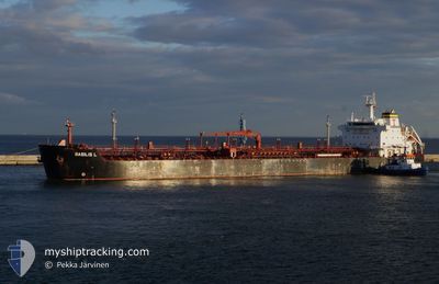
BASILIS L
Oil/Chemical Tanker
Current Trip
| Trip Time | 17 days |
|---|---|
| Trip Distance | 608.74 nm |
| AVG Speed | 6.7 Noeuds |
| MAX Speed | 13.5 Noeuds |
| Tirant d eau | 7.8 m |
| AVG Wind | 10.1 knots |
| MAX Wind | 30 knots |
| MIN Temp | 11.2°C / 52.16°F |
| MAX Temp | 19°C / 66.2°F |
| Position reçue | 1 m depuis |
Current Position
| Longitude | --- |
|---|---|
| Latitude | --- |
| Etat | Under way using engine |
| Vitesse | 8.9 Noeuds |
| Parcours | 30° |
| Zone | Aegean Sea |
| Station | T-AIS |
| Position reçue | 1 m depuis |
Info
Information
The current position of BASILIS L is in Aegean Sea with coordinates 40.57601° / 22.90721° as reported on 2025-12-05 05:12 by AIS to our vessel tracker app. The vessel's current speed is 8.9 Noeuds and is currently inside the port of THESSALONIKI.
The vessel BASILIS L (IMO: 9290505, MMSI: 538007627) is a Oil/Chemical Tanker that was built in 2005 ( 20 Age ). It's sailing under the flag of [MH] Marshall Is.
In this page you can find informations about the vessels current position, last detected port calls, and current voyage information. If the vessels is not in coverage by AIS you will find the latest position.
The current position of BASILIS L is detected by our AIS receivers and we are not responsible for the reliability of the data. The last position was recorded while the vessel was in Coverage by the Ais receivers of our vessel tracking app.
The current draught of BASILIS L as reported by AIS is 7.8 meters
Weather
| Temperature | 11.5°C / 52.7°F |
|---|---|
| Wind Speed | 7 knots |
| Direction | 42° NE |
| Pressure | 1005.6 hPa |
| Humidity | 89.8 % |
| Cloud Coverage | 100 % |
Featured Company
Last Port Calls
| Port | Arrival | Departure | Time In Port |
|---|---|---|---|
| 2025-12-05 07:07 | |||
| 2025-11-16 01:25 | 2025-11-17 23:07 | 1 d | |
| 2025-11-09 19:11 | 2025-11-13 10:55 | 3 d | |
| 2025-11-06 23:53 | 2025-11-07 01:08 | 1 h | |
| 2025-10-04 11:24 |
Most Visited Ports (Last year)
| Port | Arrivals | |
|---|---|---|
| 16 | ||
| 3 | ||
| 3 | ||
| 2 | ||
| 2 | ||
| 2 |
Last Trips
| Origin | Departure | Destination | Arrival | Distance | |
|---|---|---|---|---|---|
| 2025-11-17 23:07 | 2025-12-05 07:07 | 608.74 nm | |||
| 2025-11-13 10:55 | 2025-11-16 01:25 | 386.43 nm | |||
| 2025-11-07 01:08 | 2025-11-09 19:11 | 346.39 nm | |||
| 2025-10-04 11:24 | 2025-11-06 23:53 | 266.39 nm |
Events
| Heure | Evenement | Détails | Position/ Destination | Info |
|---|---|---|---|---|
| 2025-12-05 05:07 | Port d'arrivée |
|
40.56745 / 22.89442
[GR] THESSALONIKI
|
Vitesse: 10.1 kn Parcours: 52.5° |
| 2025-12-05 00:02 | Changement de destination | GRSKG GRPIR |
40.09403 / 23.06299
GRSKG
|
Vitesse: 12.4 kn Parcours: 322° |
| 2025-12-05 00:02 | Changement d'ETA | 2025/12/05 09:30 2026/11/19 12:00 |
40.09403 / 23.06299
GRSKG
|
Vitesse: 12.4 kn Parcours: 322° |
| 2025-12-04 23:29 | Etat Changé | Under way using engine Default |
39.99862 / 23.15351
GRPIR
|
Vitesse: 12.8 kn Parcours: 327° |
| 2025-12-04 23:15 | Etat Changé | Default Under way using engine |
39.95664 / 23.18965
GRPIR
|
Vitesse: 12.4 kn Parcours: 323.6° |
| 2025-12-04 23:00 | Etat Changé | Under way using engine Default |
39.91625 / 23.22680
GRPIR
|
Vitesse: 12.5 kn Parcours: 288° |
| 2025-12-04 22:52 | Dans la zone couverte |
39.91625 / 23.22680
Aegean Sea
|
Vitesse: 12.4 kn Parcours: 323.6° |
|
| 2025-12-04 14:57 | Etat Changé | Default Under way using engine |
39.67194 / 25.38877
GRPIR
|
Vitesse: 10.9 kn Parcours: 226.8° |
| 2025-12-04 14:50 | Etat Changé | Under way using engine Default |
39.67865 / 25.41695
GRPIR
|
Vitesse: 10.8 kn Parcours: 222° |
| 2025-12-04 14:50 | Hors de la zone couverte |
39.67865 / 25.41695
Aegean Sea
|
Vitesse: 10.9 kn Parcours: 226.8° |