
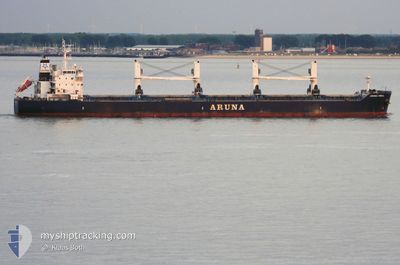
ARUNA ISMAIL
Bulk Carrier
Current Trip
| Time Travelled | 13 days |
|---|---|
| Remaining Time | --- |
| Distance Travelled | 3436.07 nm |
| Remaining Distance | --- |
| AVG Speed | 10.9 Noeuds |
| MAX Speed | 14.1 Noeuds |
| AVG Wind | 8.7 knots |
| MAX Wind | 29 knots |
| MIN Temp | 16°C / 60.8°F |
| MAX Temp | 25.5°C / 77.9°F |
| Tirant d eau | 11.1 m |
| Position reçue | 3 h, 17 m depuis |
Current Position
| Longitude | 22.65453° |
|---|---|
| Latitude | 38.33853° |
| Etat | Under way using engine |
| Vitesse | 6.5 Noeuds |
| Parcours | 8.2° |
| Zone | Ionian Sea |
| Station | T-AIS |
| Position reçue | 3 h, 17 m depuis |
Info
Information
The current position of ARUNA ISMAIL is in Ionian Sea with coordinates 38.33853° / 22.65453° as reported on 2024-04-29 20:14 by AIS to our vessel tracker app. The vessel's current speed is 6.5 Noeuds
The vessel ARUNA ISMAIL (IMO: 9637296, MMSI: 538004999) is a Bulk Carrier that was built in 2013 ( 11 Age ). It's sailing under the flag of [MH] Marshall Is.
In this page you can find informations about the vessels current position, last detected port calls, and current voyage information. If the vessels is not in coverage by AIS you will find the latest position.
The current position of ARUNA ISMAIL is detected by our AIS receivers and we are not responsible for the reliability of the data. The last position was recorded while the vessel was in Coverage by the Ais receivers of our vessel tracking app.
The current draught of ARUNA ISMAIL as reported by AIS is 11.1 meters
Weather
| Temperature | 16.9°C / 62.42°F |
|---|---|
| Wind Speed | 7 knots |
| Direction | 32° NNE |
| Pressure | 1021.7 hPa |
| Humidity | 64.6 % |
| Cloud Coverage | --- |
Featured Company
Last Port Calls
| Port | Arrival | Departure | Time In Port |
|---|---|---|---|
| 2024-04-14 11:23 | 2024-04-15 23:52 | 1 d | |
| 2024-03-31 14:32 | 2024-04-08 08:00 | 7 d | |
| 2024-03-19 10:48 | 2024-03-30 18:44 | 11 d | |
| 2024-02-20 12:31 | 2024-02-27 09:02 | 6 d | |
| 2024-02-11 15:20 | 2024-02-12 15:37 | 1 d | |
| 2024-02-04 17:20 | 2024-02-08 12:25 | 3 d |
Most Visited Ports (Last year)
| Port | Arrivals | |
|---|---|---|
| 2 | ||
| 1 | ||
| 1 | ||
| 1 | ||
| 1 | ||
| 1 |
Last Trips
| Origin | Departure | Destination | Arrival | Distance | |
|---|---|---|---|---|---|
| 2024-04-08 09:00 | 2024-04-14 11:23 | 1496.50 nm | |||
| 2024-03-30 19:44 | 2024-03-31 15:32 | 184.36 nm | |||
| 2024-02-27 11:02 | 2024-03-19 11:48 | 5259.54 nm | |||
| 2024-02-12 16:37 | 2024-02-20 14:31 | 2342.50 nm | |||
| 2024-02-08 13:25 | 2024-02-11 16:20 | 139.37 nm | |||
| 2024-01-12 14:54 | 2024-02-04 18:20 | 5310.34 nm |
Events
| Heure | Evenement | Détails | Position/ Destination | Info |
|---|---|---|---|---|
| 2024-04-29 20:44 | Arret | 1.23 nm, West of AGIOS NIKOLAOS |
38.35743 / 22.65852
GR STN
|
Vitesse: 0.3 kn Parcours: 96° |
| 2024-04-29 20:20 | Etat Changé | Default Under way using engine |
38.34760 / 22.65607
GR STN
|
Vitesse: 6.5 kn Parcours: 8.2° |
| 2024-04-29 20:14 | Hors de la zone couverte |
38.33853 / 22.65453
Ionian Sea
GR STN
|
Vitesse: 6.5 kn Parcours: 8.2° |
|
| 2024-04-29 19:04 | Etat Changé | Under way using engine Default |
38.25490 / 22.48617
GR STN
|
Vitesse: 12.1 kn Parcours: 99° |
| 2024-04-29 19:04 | Dans la zone couverte |
38.25490 / 22.48617
Ionian Sea
GR STN
|
Vitesse: 11.6 kn Parcours: 99.6° |
|
| 2024-04-29 17:44 | Etat Changé | Default Under way using engine |
38.29707 / 22.15677
GR STN
|
Vitesse: 11.3 kn Parcours: 109.9° |
| 2024-04-29 17:38 | Etat Changé | Under way using engine Default |
38.30388 / 22.13299
GR STN
|
Vitesse: 11.2 kn Parcours: 109° |
| 2024-04-29 17:38 | Hors de la zone couverte |
38.30388 / 22.13299
Ionian Sea
GR STN
|
Vitesse: 11.3 kn Parcours: 109.9° |
|
| 2024-04-29 17:32 | Etat Changé | Default Under way using engine |
38.31007 / 22.11112
GR STN
|
Vitesse: 11.2 kn Parcours: 109.8° |
| 2024-04-29 13:13 | Etat Changé | Under way using engine Default |
38.14124 / 21.14398
GR STN
|
Vitesse: 11.8 kn Parcours: 60° |