
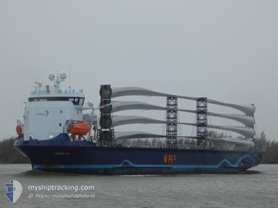
ADRIATIC
Cargo
Current Trip
| Time Travelled | 1 day |
|---|---|
| Remaining Time | 22 h, 42 mins |
| Distance Travelled | 358.84 nm |
| Remaining Distance | 251.13 nm |
| AVG Speed | 12.3 Noeuds |
| MAX Speed | 14 Noeuds |
| AVG Wind | 12.4 knots |
| MAX Wind | 29.8 knots |
| MIN Temp | 19.5°C / 67.1°F |
| MAX Temp | 22°C / 71.6°F |
| Tirant d eau | 3.8 m |
| Position reçue | 1 m depuis |
Current Position
| Longitude | 28.44031° |
|---|---|
| Latitude | 36.41530° |
| Etat | Under way using engine |
| Vitesse | 11.3 Noeuds |
| Parcours | 291.4° |
| Zone | Mediterranean Sea - Eastern Basin |
| Station | T-AIS |
| Position reçue | 1 m depuis |
Info
Information
The current position of ADRIATIC is in Mediterranean Sea - Eastern Basin with coordinates 36.41530° / 28.44031° as reported on 2024-05-02 19:12 by AIS to our vessel tracker app. The vessel's current speed is 11.3 Noeuds and is heading at the port of IZMIR. The estimated time of arrival as calculated by MyShipTracking vessel tracking app is 2024-05-03 17:55 LT
The vessel ADRIATIC (IMO: 9944871, MMSI: 246269000) is a Cargo It's sailing under the flag of [NL] Netherlands.
In this page you can find informations about the vessels current position, last detected port calls, and current voyage information. If the vessels is not in coverage by AIS you will find the latest position.
The current position of ADRIATIC is detected by our AIS receivers and we are not responsible for the reliability of the data. The last position was recorded while the vessel was in Coverage by the Ais receivers of our vessel tracking app.
The current draught of ADRIATIC as reported by AIS is 3.8 meters
Weather
| Temperature | 20°C / 68°F |
|---|---|
| Wind Speed | 25 knots |
| Direction | 280° W |
| Pressure | 1007.8 hPa |
| Humidity | 74.4 % |
| Cloud Coverage | --- |
Featured Company
Last Port Calls
| Port | Arrival | Departure | Time In Port |
|---|---|---|---|
| 2024-04-30 14:59 | 2024-05-01 13:32 | 22 h | |
| 2024-04-18 05:35 | 2024-04-18 11:55 | 6 h | |
| 2024-04-16 16:03 | 2024-04-17 15:51 | 23 h | |
| 2024-04-11 04:05 | 2024-04-12 19:38 | 1 d | |
| 2024-03-29 11:42 | 2024-03-30 22:32 | 1 d | |
| 2024-03-26 07:24 | 2024-03-27 12:29 | 1 d | |
| 2024-03-12 17:05 | 2024-03-13 16:00 | 22 h |
Last Trips
| Origin | Departure | Destination | Arrival | Distance | |
|---|---|---|---|---|---|
| 2024-04-18 13:55 | 2024-04-30 17:59 | 3451.82 nm | |||
| 2024-04-17 16:51 | 2024-04-18 07:35 | 115.89 nm | |||
| 2024-04-12 20:38 | 2024-04-16 17:03 | 788.34 nm | |||
| 2024-03-31 01:32 | 2024-04-11 05:05 | 3036.41 nm | |||
| 2024-03-27 14:29 | 2024-03-29 14:42 | 598.92 nm | |||
| 2024-03-13 16:00 | 2024-03-26 09:24 | 3348.59 nm | |||
| 2024-02-28 22:16 | 2024-03-12 17:05 | 2015.68 nm |
Events
| Heure | Evenement | Détails | Position/ Destination | Info |
|---|---|---|---|---|
| 2024-05-02 18:31 | Changement de zone | Greek part of the Mediterranean Sea - Eastern Basin Turkish part of the Mediterranean Sea - Eastern Basin |
36.36976 / 28.58660
Mediterranean Sea - Eastern Basin
IZMIR
|
Vitesse: 11.2 kn Parcours: 291.4° |
| 2024-05-02 14:40 | Changement de zone | Turkish part of the Mediterranean Sea - Eastern Basin Greek part of the Mediterranean Sea - Eastern Basin |
36.12418 / 29.40893
Mediterranean Sea - Eastern Basin
IZMIR
|
Vitesse: 10.3 kn Parcours: 288.6° |
| 2024-05-02 13:34 | Changement de zone | Greek part of the Mediterranean Sea - Eastern Basin Turkish part of the Mediterranean Sea - Eastern Basin |
36.06586 / 29.63109
Mediterranean Sea - Eastern Basin
IZMIR
|
Vitesse: 10.2 kn Parcours: 290.3° |
| 2024-05-02 12:58 | Etat Changé | Under way using engine Default |
36.05382 / 29.76343
IZMIR
|
Vitesse: 10 kn Parcours: 276° |
| 2024-05-02 12:35 | Etat Changé | Default Under way using engine |
36.04666 / 29.84500
IZMIR
|
Vitesse: 10.3 kn Parcours: 273.4° |
| 2024-05-02 11:46 | Etat Changé | Under way using engine Default |
36.03836 / 30.02539
IZMIR
|
Vitesse: 11.3 kn Parcours: 274° |
| 2024-05-02 11:36 | Dans la zone couverte |
36.03836 / 30.02539
Mediterranean Sea - Eastern Basin
IZMIR
|
Vitesse: 11.1 kn Parcours: 274.4° |
|
| 2024-05-01 22:32 | Etat Changé | Default Under way using engine |
35.83041 / 33.39609
IZMIR
|
Vitesse: 12.6 kn Parcours: 274.4° |
| 2024-05-01 22:28 | Hors de la zone couverte |
35.82930 / 33.41391
Mediterranean Sea - Eastern Basin
IZMIR
|
Vitesse: 12.6 kn Parcours: 274.4° |
|
| 2024-05-01 22:27 | Etat Changé | Under way using engine Default |
35.82912 / 33.41672
IZMIR
|
Vitesse: 13 kn Parcours: 275° |