
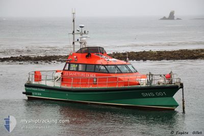
SNS001 Y & F OLIVAUX
Search and Rescue vessel
Current Trip
| Trip Time | 1 h, 41 mins |
|---|---|
| Trip Distance | 25.17 nm |
| AVG Speed | 23 Knots |
| MAX Speed | 25.7 Knots |
| Dybgang | 1.6 m |
| AVG Wind | 8.5 knots |
| MAX Wind | 9 knots |
| MIN Temp | 14.2°C / 57.56°F |
| MAX Temp | 14.7°C / 58.46°F |
| Position Modtaget | 1 d siden |
Current Position
| Longitude | -4.84792° |
|---|---|
| Latitude | 48.03867° |
| Status | Under way using engine |
| Fart | 0.1 Knots |
| Kurs | --- |
| Område | Celtic Sea |
| Station | T-AIS |
| Position Modtaget | 1 d siden |
Info
Information
The current position of SNS001 Y & F OLIVAUX is in Celtic Sea with coordinates 48.03867° / -4.84792° as reported on 2024-05-11 06:37 by AIS to our vessel tracker app. The vessel's current speed is 0.1 Knots and is currently inside the port of SEIN.
The vessel SNS001 Y & F OLIVAUX (MMSI: 227400510) is a Search and Rescue vessel It's sailing under the flag of [FR] France.
In this page you can find informations about the vessels current position, last detected port calls, and current voyage information. If the vessels is not in coverage by AIS you will find the latest position.
The current position of SNS001 Y & F OLIVAUX is detected by our AIS receivers and we are not responsible for the reliability of the data. The last position was recorded while the vessel was in Coverage by the Ais receivers of our vessel tracking app.
The current draught of SNS001 Y & F OLIVAUX as reported by AIS is 1.6 meters
Weather
| Temperature | 14.6°C / 58.28°F |
|---|---|
| Wind Speed | 9 knots |
| Direction | 88° E |
| Pressure | 1016.2 hPa |
| Humidity | 87.1 % |
| Cloud Coverage | 100 % |
Featured Company
Last Port Calls
| Port | Arrival | Departure | Time In Port |
|---|---|---|---|
| 2024-05-11 08:26 | |||
| 2024-05-08 18:50 | 2024-05-11 06:45 | 2 d | |
| 2024-04-28 10:18 | 2024-05-08 18:43 | 10 d | |
| 2024-04-23 23:05 | 2024-04-28 08:11 | 4 d | |
| 2024-04-22 12:25 | 2024-04-23 21:39 | 1 d | |
| 2024-04-19 12:27 | 2024-04-22 11:08 | 2 d | |
| 2024-04-12 14:57 | 2024-04-19 11:36 | 6 d | |
| 2024-04-12 12:51 |
Last Trips
| Origin | Departure | Destination | Arrival | Distance | |
|---|---|---|---|---|---|
| 2024-05-11 06:45 | 2024-05-11 08:26 | 25.17 nm | |||
| 2024-05-08 18:43 | 2024-05-08 18:50 | 2.86 nm | |||
| 2024-04-28 08:11 | 2024-04-28 10:18 | 25.45 nm | |||
| 2024-04-23 21:39 | 2024-04-23 23:05 | 18.58 nm | |||
| 2024-04-22 11:08 | 2024-04-22 12:25 | 6.27 nm | |||
| 2024-04-19 11:36 | 2024-04-19 12:27 | 10.83 nm | |||
| 2024-04-12 12:51 | 2024-04-12 14:57 | 26.24 nm |
Events
| Tid | Hændelsen | Detaljer | Position / Dest | Info |
|---|---|---|---|---|
| 2024-05-11 06:37 | Udenfor Dækning |
48.03867 / -4.84792
Celtic Sea
[FR] SEIN
|
Fart: 0.1 kn Kurs: 117.1° |
|
| 2024-05-11 06:28 | STOP Sejllads |
48.03872 / -4.84783
[FR] SEIN
|
Fart: 0.3 kn Kurs: 511° |
|
| 2024-05-11 06:26 | Skibe i havn |
|
48.04060 / -4.84785
[FR] SEIN
|
Fart: 19.9 kn Kurs: 205.4° |
| 2024-05-11 06:00 | Destination er ændret | ILE DE SEIN EVA SANITAIRE |
48.00193 / -4.61762
ILE DE SEIN
|
Fart: 24.5 kn Kurs: 289.6° |
| 2024-05-11 04:59 | Destination er ændret | EVA SANITAIRE ROUTE SEIN |
48.03687 / -4.76933
EVA SANITAIRE
|
Fart: 24.3 kn Kurs: 101.7° |
| 2024-05-11 04:51 | START Sejllads | 0.43 nm, North of SEIN |
48.04325 / -4.84704
ROUTE SEIN
|
Fart: 19.7 kn Kurs: 107.4° |
| 2024-05-11 04:47 | STOP Sejllads | 0.45 nm, North of SEIN |
48.04347 / -4.85012
ROUTE SEIN
|
Fart: 0.3 kn Kurs: 511° |
| 2024-05-11 04:45 | Afsejlet fra sidste havn |
|
48.04268 / -4.84963
ROUTE SEIN
|
Fart: 12.2 kn Kurs: 323.6° |
| 2024-05-11 04:44 | START Sejllads |
48.04068 / -4.84772
[FR] SEIN
|
Fart: 9.3 kn Kurs: 340° |
|
| 2024-05-11 04:31 | Indenfor Dækning |
48.03869 / -4.84792
Celtic Sea
[FR] SEIN
|
Fart: 0.1 kn Kurs: 165.2° |