
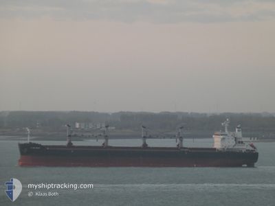
SPAR VEGA
Cargo
Current Trip
| Time Travelled | 20 days |
|---|---|
| Remaining Time | --- |
| Distance Travelled | 4680.69 nm |
| Remaining Distance | --- |
| AVG Speed | 10 Knots |
| MAX Speed | 18.9 Knots |
| AVG Wind | 10.8 knots |
| MAX Wind | 24.3 knots |
| MIN Temp | 13.8°C / 56.84°F |
| MAX Temp | 27.4°C / 81.32°F |
| Dybgang | 12.8 m |
| Position Modtaget | 8 d siden |
Current Position
| Longitude | -11.90527° |
|---|---|
| Latitude | 35.44556° |
| Status | Under way using engine |
| Fart | 10.9 Knots |
| Kurs | 261.5° |
| Område | North Atlantic Ocean |
| Station | T-AIS |
| Position Modtaget | 8 d siden |
Info
Information
The current position of SPAR VEGA is in North Atlantic Ocean with coordinates 35.44556° / -11.90527° as reported on 2024-06-07 16:40 by AIS to our vessel tracker app. The vessel's current speed is 10.9 Knots and is heading at the port of CRISTOBAL. The estimated time of arrival as calculated by MyShipTracking vessel tracking app is 2024-06-22 20:00 LT
The vessel SPAR VEGA (IMO: 9490870, MMSI: 259099000) is a Cargo It's sailing under the flag of [NO] Norway.
In this page you can find informations about the vessels current position, last detected port calls, and current voyage information. If the vessels is not in coverage by AIS you will find the latest position.
The current position of SPAR VEGA is detected by our AIS receivers and we are not responsible for the reliability of the data. The last position was recorded while the vessel was in Coverage by the Ais receivers of our vessel tracking app.
The current draught of SPAR VEGA as reported by AIS is 12.8 meters
Weather
| Temperature | 27.4°C / 81.32°F |
|---|---|
| Wind Speed | 13 knots |
| Direction | 115° ESE |
| Pressure | 1018.9 hPa |
| Humidity | 75.8 % |
| Cloud Coverage | 72 % |
Featured Company
Last Port Calls
| Port | Arrival | Departure | Time In Port |
|---|---|---|---|
| 2024-05-19 18:58 | 2024-05-26 22:41 | 7 d | |
| 2024-05-13 15:28 | 2024-05-17 22:19 | 4 d |
Most Visited Ports (Last year)
| Port | Arrivals | |
|---|---|---|
| 3 | ||
| 2 | ||
| 2 | ||
| 1 | ||
| 1 | ||
| 1 |
Last Trips
| Origin | Departure | Destination | Arrival | Distance | |
|---|---|---|---|---|---|
| 2024-03-26 15:56 | 2024-05-19 21:58 | 9131.35 nm | |||
| 2024-03-26 15:56 | 2024-05-13 17:28 | 8503.56 nm |
Events
| Tid | Hændelsen | Detaljer | Position / Dest | Info |
|---|---|---|---|---|
| 2024-06-07 16:43 | Status er ændret | Default Under way using engine |
35.44408 / -11.91850
PA CTB
|
Fart: 10.9 kn Kurs: 261.5° |
| 2024-06-07 16:40 | Udenfor Dækning |
35.44556 / -11.90527
North Atlantic Ocean
PA CTB
|
Fart: 10.9 kn Kurs: 261.5° |
|
| 2024-06-07 16:35 | Status er ændret | Under way using engine Default |
35.44740 / -11.88809
PA CTB
|
Fart: 10.8 kn Kurs: 261° |
| 2024-06-07 16:35 | Indenfor Dækning |
35.44740 / -11.88809
North Atlantic Ocean
PA CTB
|
Fart: 10.8 kn Kurs: 262.7° |
|
| 2024-06-07 05:23 | Status er ændret | Default Under way using engine |
35.68628 / -9.57817
PA CTB
|
Fart: 10.2 kn Kurs: 265.2° |
| 2024-06-07 05:17 | Udenfor Dækning |
35.68768 / -9.55731
North Atlantic Ocean
PA CTB
|
Fart: 10.2 kn Kurs: 265.2° |
|
| 2024-06-07 05:17 | Status er ændret | Under way using engine Default |
35.68771 / -9.55674
PA CTB
|
Fart: 10.1 kn Kurs: 265° |
| 2024-06-07 04:55 | Status er ændret | Default Under way using engine |
35.69423 / -9.47933
PA CTB
|
Fart: 10.2 kn Kurs: 262.5° |
| 2024-06-07 04:39 | Status er ændret | Under way using engine Default |
35.69956 / -9.42534
PA CTB
|
Fart: 10.1 kn Kurs: 263° |
| 2024-06-07 04:35 | Status er ændret | Default Under way using engine |
35.70087 / -9.41155
PA CTB
|
Fart: 10 kn Kurs: 262.9° |