
NORTHERN WIND
Dredging or underwater ops
Current Trip
SURVEY AREA
| Time Travelled | 2 days |
|---|---|
| Remaining Time | --- |
| Distance Travelled | 480.66 nm |
| Remaining Distance | --- |
| AVG Speed | 9.6 Knots |
| MAX Speed | 16.4 Knots |
| AVG Wind | 7.3 knots |
| MAX Wind | 13.8 knots |
| MIN Temp | 9.4°C / 48.92°F |
| MAX Temp | 14.7°C / 58.46°F |
| Dybgang | 1.6 m |
| Position Modtaget | 1 m siden |
Current Position
| Longitude | -3.62763° |
|---|---|
| Latitude | 58.71959° |
| Status | Restricted manoeuverability |
| Fart | 12.5 Knots |
| Kurs | 86.1° |
| Område | North Atlantic Ocean |
| Station | T-AIS |
| Position Modtaget | 1 m siden |
Info
Information
The current position of NORTHERN WIND is in North Atlantic Ocean with coordinates 58.71959° / -3.62763° as reported on 2024-05-11 22:44 by AIS to our vessel tracker app. The vessel's current speed is 12.5 Knots
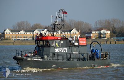
The vessel NORTHERN WIND (MMSI: 235111562) is a Dredging or underwater ops It's sailing under the flag of [GB] United Kingdom.
In this page you can find informations about the vessels current position, last detected port calls, and current voyage information. If the vessels is not in coverage by AIS you will find the latest position.
The current position of NORTHERN WIND is detected by our AIS receivers and we are not responsible for the reliability of the data. The last position was recorded while the vessel was in Coverage by the Ais receivers of our vessel tracking app.
The current draught of NORTHERN WIND as reported by AIS is 1.6 meters
Weather
| Temperature | 11.8°C / 53.24°F |
|---|---|
| Wind Speed | 5 knots |
| Direction | 209° SSW |
| Pressure | 1015.9 hPa |
| Humidity | 83.2 % |
| Cloud Coverage | 86 % |
Featured Company
Last Port Calls
| Port | Arrival | Departure | Time In Port |
|---|---|---|---|
| 2024-05-09 13:30 | 2024-05-09 13:36 | 6 m | |
| 2024-05-07 16:26 | 2024-05-08 13:17 | 20 h | |
| 2024-05-01 22:13 | 2024-05-03 18:31 | 1 d | |
| 2024-04-28 01:31 | 2024-04-28 22:12 | 20 h | |
| 2024-04-14 12:24 | 2024-04-27 11:06 | 12 d | |
| 2024-04-09 07:41 | 2024-04-11 05:30 | 1 d | |
| 2024-04-05 02:26 | 2024-04-08 03:32 | 3 d | |
| 2024-03-31 17:21 | 2024-04-01 13:56 | 20 h | |
| 2024-03-26 14:15 | 2024-03-29 20:55 | 3 d | |
| 2024-03-24 21:31 | 2024-03-25 04:51 | 7 h |
Most Visited Ports (Last year)
| Port | Arrivals | |
|---|---|---|
| 30 | ||
| 16 | ||
| 12 | ||
| 9 | ||
| 7 | ||
| 4 |
Last Trips
| Origin | Departure | Destination | Arrival | Distance | |
|---|---|---|---|---|---|
| 2024-05-08 14:17 | 2024-05-09 14:30 | 219.94 nm | |||
| 2024-05-03 19:31 | 2024-05-07 17:26 | 478.54 nm | |||
| 2024-04-28 23:12 | 2024-05-01 23:13 | 449.94 nm | |||
| 2024-04-27 12:06 | 2024-04-28 02:31 | 98.26 nm | |||
| 2024-04-11 06:30 | 2024-04-14 13:24 | 558.04 nm | |||
| 2024-04-08 04:32 | 2024-04-09 08:41 | 150.27 nm | |||
| 2024-04-01 14:56 | 2024-04-05 03:26 | 133.98 nm | |||
| 2024-03-29 20:55 | 2024-03-31 18:21 | 110.53 nm | |||
| 2024-03-25 04:51 | 2024-03-26 14:15 | 340.51 nm | |||
| 2024-03-24 15:59 | 2024-03-24 21:31 | 49.88 nm |
Events
| Tid | Hændelsen | Detaljer | Position / Dest | Info |
|---|---|---|---|---|
| 2024-05-11 21:33 | Ændre havområde | United Kingdom part of the North Atlantic Ocean United Kingdom part of the North Sea |
58.72358 / -3.41297
North Atlantic Ocean
SURVEY AREA
|
Fart: 10.2 kn Kurs: 267.3° |
| 2024-05-11 21:07 | Ændre havområde | United Kingdom part of the North Sea United Kingdom part of the North Atlantic Ocean |
58.72283 / -3.39501
North Sea
SURVEY AREA
|
Fart: 10.2 kn Kurs: 87.7° |
| 2024-05-11 19:19 | Ændre havområde | United Kingdom part of the North Atlantic Ocean United Kingdom part of the North Sea |
58.72153 / -3.41380
North Atlantic Ocean
SURVEY AREA
|
Fart: 11.6 kn Kurs: 269° |
| 2024-05-11 19:04 | Ændre havområde | United Kingdom part of the North Sea United Kingdom part of the North Atlantic Ocean |
58.72059 / -3.39467
North Sea
SURVEY AREA
|
Fart: 10.2 kn Kurs: 90.5° |
| 2024-05-11 17:45 | Status er ændret | Restricted manoeuverability Under way using engine |
58.71284 / -3.51218
SURVEY AREA
|
Fart: 12.2 kn Kurs: 10.5° |
| 2024-05-11 17:44 | ETA er ændret | 2024/05/13 20:00 2024/05/09 20:00 |
58.70968 / -3.51318
SURVEY AREA
|
Fart: 12.2 kn Kurs: 10.3° |
| 2024-05-11 17:20 | Indenfor Dækning |
58.63778 / -3.52516
North Atlantic Ocean
|
Fart: 12.4 kn Kurs: 11.1° |
|
| 2024-05-11 13:50 | Udenfor Dækning |
58.71917 / -3.42188
North Atlantic Ocean
|
Fart: 10.5 kn Kurs: 264.3° |
|
| 2024-05-11 13:49 | Ændre havområde | United Kingdom part of the North Atlantic Ocean United Kingdom part of the North Sea |
58.71936 / -3.41634
North Atlantic Ocean
|
Fart: 10.4 kn Kurs: 265.2° |
| 2024-05-11 13:34 | Fundet i havområde | United Kingdom part of the North Sea |
58.71842 / -3.39043
North Sea
|
Fart: 9.3 kn Kurs: 89° |