
MEDWAY
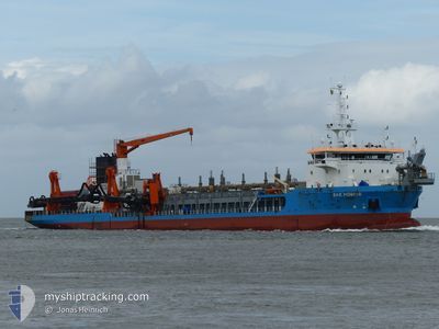
Trailing Suction Hopper Dredger
Current Trip
JADE DREDGING
| Time Travelled | 2 days |
|---|---|
| Remaining Time | --- |
| Distance Travelled | 206.23 nm |
| Remaining Distance | --- |
| AVG Speed | 9.7 Knots |
| MAX Speed | 16.1 Knots |
| AVG Wind | 14.6 knots |
| MAX Wind | 21 knots |
| MIN Temp | 8.6°C / 47.48°F |
| MAX Temp | 11.2°C / 52.16°F |
| Dybgang | 6.8 m |
| Position Modtaget | 1 h, 16 m siden |
Current Position
| Longitude | --- |
|---|---|
| Latitude | --- |
| Status | At anchor |
| Fart | |
| Kurs | 186° |
| Område | North Sea |
| Station | T-AIS |
| Position Modtaget | 1 h, 16 m siden |
Info
Information
The current position of MEDWAY is in North Sea with coordinates 53.72832° / 8.07268° as reported on 2025-12-10 08:37 by AIS to our vessel tracker app. The vessel's current speed is 0 Knots
The vessel MEDWAY (IMO: 9524152, MMSI: 209416000) is a Trailing Suction Hopper Dredger that was built in 2012 ( 13 år gamle ). It's sailing under the flag of [CY] Cyprus.
In this page you can find informations about the vessels current position, last detected port calls, and current voyage information. If the vessels is not in coverage by AIS you will find the latest position.
The current position of MEDWAY is detected by our AIS receivers and we are not responsible for the reliability of the data. The last position was recorded while the vessel was in Coverage by the Ais receivers of our vessel tracking app.
The current draught of MEDWAY as reported by AIS is 6.8 meters
Weather
| Temperature | 10.5°C / 50.9°F |
|---|---|
| Wind Speed | 14 knots |
| Direction | 233° SW |
| Pressure | 1012.9 hPa |
| Humidity | 88.9 % |
| Cloud Coverage | 100 % |
Featured Company
Last Port Calls
| Port | Arrival | Departure | Time In Port |
|---|---|---|---|
| 2025-12-08 08:19 | 2025-12-08 08:48 | 28 m | |
| 2025-12-08 07:45 | 2025-12-08 07:55 | 9 m | |
| 2025-12-08 07:01 | 2025-12-08 07:24 | 22 m | |
| 2025-12-08 05:58 | 2025-12-08 06:31 | 32 m | |
| 2025-12-06 15:10 | 2025-12-06 17:13 | 2 h | |
| 2025-12-06 12:17 | 2025-12-06 14:18 | 2 h | |
| 2025-12-06 09:56 | 2025-12-06 10:32 | 35 m | |
| 2025-12-06 07:18 | 2025-12-06 07:49 | 30 m | |
| 2025-12-06 06:10 | 2025-12-06 06:35 | 25 m | |
| 2025-12-06 05:32 |
Most Visited Ports (Last year)
| Port | Arrivals | |
|---|---|---|
| 668 | ||
| 142 | ||
| 17 | ||
| 4 | ||
| 4 | ||
| 2 |
Last Trips
| Origin | Departure | Destination | Arrival | Distance | |
|---|---|---|---|---|---|
| 2025-12-08 07:55 | 2025-12-08 08:19 | 4.74 nm | |||
| 2025-12-08 07:24 | 2025-12-08 07:45 | 0.81 nm | |||
| 2025-12-08 06:31 | 2025-12-08 07:01 | 1.77 nm | |||
| 2025-12-06 17:13 | 2025-12-08 05:58 | 158.05 nm | |||
| 2025-12-06 14:18 | 2025-12-06 15:10 | 6.60 nm | |||
| 2025-12-06 10:32 | 2025-12-06 12:17 | 18.01 nm | |||
| 2025-12-06 07:49 | 2025-12-06 09:56 | 9.26 nm | |||
| 2025-12-06 06:35 | 2025-12-06 07:18 | 6.55 nm | |||
| 2025-12-06 05:00 | 2025-12-06 06:10 | 5.22 nm | |||
| 2025-12-06 05:00 | 2025-12-06 05:32 | 0.93 nm |
Events
| Tid | Hændelsen | Detaljer | Position / Dest | Info |
|---|---|---|---|---|
| 2025-12-10 08:46 | Status er ændret | Default At anchor |
53.72831 / 8.07271
JADE DREDGING
|
Fart: Kurs: 186° |
| 2025-12-10 08:37 | Status er ændret | At anchor Default |
53.72832 / 8.07268
JADE DREDGING
|
Fart: Kurs: -1° |
| 2025-12-10 08:37 | Udenfor Dækning |
53.72832 / 8.07268
North Sea
|
Fart: Kurs: 281° |
|
| 2025-12-10 08:22 | Indenfor Dækning |
53.72832 / 8.07268
North Sea
|
Fart: Kurs: 281° |
|
| 2025-12-10 06:52 | Status er ændret | Default At anchor |
53.72832 / 8.07265
JADE DREDGING
|
Fart: 0.3 kn Kurs: 197° |
| 2025-12-10 06:47 | Status er ændret | At anchor Restricted manoeuverability |
53.72832 / 8.07269
JADE DREDGING
|
Fart: 1.2 kn Kurs: 193° |
| 2025-12-10 06:47 | STOP Sejllads | 3.24 nm, North East of WANGERSIEL |
53.72832 / 8.07269
JADE DREDGING
|
Fart: 0.3 kn Kurs: 197° |
| 2025-12-10 06:47 | Udenfor Dækning |
53.72832 / 8.07269
North Sea
|
Fart: 0.3 kn Kurs: 282.9° |
|
| 2025-12-10 06:44 | Status er ændret | Restricted manoeuverability Default |
53.72800 / 8.07390
JADE DREDGING
|
Fart: 1.1 kn Kurs: 142° |
| 2025-12-10 05:57 | Status er ændret | Default Restricted manoeuverability |
53.78858 / 8.02914
JADE DREDGING
|
Fart: 8.4 kn Kurs: 122.3° |