
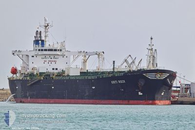
KRITI ROCK
Oil Products Tanker
Current Trip
| Trip Time | 9 days |
|---|---|
| Trip Distance | 2500.18 nm |
| AVG Speed | 11.3 Knots |
| MAX Speed | 15.5 Knots |
| Dybgang | 12 m |
| AVG Wind | 11.4 knots |
| MAX Wind | 37 knots |
| MIN Temp | 8°C / 46.4°F |
| MAX Temp | 18°C / 64.4°F |
| Position Modtaget | 22 h, 50 m siden |
Current Position
| Longitude | --- |
|---|---|
| Latitude | --- |
| Status | Under way using engine |
| Fart | |
| Kurs | 341° |
| Område | Mediterranean Sea - Eastern Basin |
| Station | T-AIS |
| Position Modtaget | 22 h, 50 m siden |
Info
Information
The current position of KRITI ROCK is in Mediterranean Sea - Eastern Basin with coordinates 35.81118° / 14.67161° as reported on 2025-12-12 12:05 by AIS to our vessel tracker app. The vessel's current speed is 0 Knots and is currently inside the port of MARSAXLOKK.
The vessel KRITI ROCK (IMO: 9392315, MMSI: 636019277) is a Oil Products Tanker that was built in 2008 ( 17 år gamle ). It's sailing under the flag of [LR] Liberia.
In this page you can find informations about the vessels current position, last detected port calls, and current voyage information. If the vessels is not in coverage by AIS you will find the latest position.
The current position of KRITI ROCK is detected by our AIS receivers and we are not responsible for the reliability of the data. The last position was recorded while the vessel was in Coverage by the Ais receivers of our vessel tracking app.
The current draught of KRITI ROCK as reported by AIS is 12 meters
Weather
| Temperature | 17.4°C / 63.32°F |
|---|---|
| Wind Speed | 11 knots |
| Direction | 85° E |
| Pressure | 1024.1 hPa |
| Humidity | 68.2 % |
| Cloud Coverage | 94 % |
Featured Company
Last Port Calls
| Port | Arrival | Departure | Time In Port |
|---|---|---|---|
| 2025-12-12 15:33 | |||
| 2025-11-29 16:17 | 2025-12-02 21:43 | 3 d | |
| 2025-11-17 19:14 | 2025-11-19 16:05 | 1 d | |
| 2025-11-04 13:37 | 2025-11-08 09:23 | 3 d | |
| 2025-10-25 13:28 | 2025-10-27 18:56 | 2 d | |
| 2025-10-14 14:42 | 2025-10-17 04:32 | 2 d | |
| 2025-10-10 11:27 | 2025-10-12 13:25 | 2 d | |
| 2025-10-02 06:20 |
Most Visited Ports (Last year)
| Port | Arrivals | |
|---|---|---|
| 3 | ||
| 3 | ||
| 3 | ||
| 3 | ||
| 3 | ||
| 2 |
Last Trips
| Origin | Departure | Destination | Arrival | Distance | |
|---|---|---|---|---|---|
| 2025-12-02 21:43 | 2025-12-12 15:33 | 2500.18 nm | |||
| 2025-11-19 16:05 | 2025-11-29 16:17 | 1634.92 nm | |||
| 2025-11-08 09:23 | 2025-11-17 19:14 | 2032.05 nm | |||
| 2025-10-27 18:56 | 2025-11-04 13:37 | 660.06 nm | |||
| 2025-10-17 04:32 | 2025-10-25 13:28 | 1024.89 nm | |||
| 2025-10-12 13:25 | 2025-10-14 14:42 | 349.24 nm | |||
| 2025-10-02 06:20 | 2025-10-10 11:27 | 388.40 nm |
Events
| Tid | Hændelsen | Detaljer | Position / Dest | Info |
|---|---|---|---|---|
| 2025-12-12 14:45 | STOP Sejllads |
35.81657 / 14.54557
[MT] MARSAXLOKK
|
Fart: 0.3 kn Kurs: 44° |
|
| 2025-12-12 14:33 | Skibe i havn |
|
35.81910 / 14.54950
[MT] MARSAXLOKK
|
Fart: 2.9 kn Kurs: 302° |
| 2025-12-12 14:11 | START Sejllads | 2.14 nm, South East of MARSAXLOKK |
35.80235 / 14.58200
MTMAR
|
Fart: 4.4 kn Kurs: 300° |
| 2025-12-12 14:05 | STOP Sejllads | 2.34 nm, South East of MARSAXLOKK |
35.79990 / 14.58502
MTMAR
|
Fart: 0.1 kn Kurs: 295° |
| 2025-12-12 13:09 | START Sejllads | 5.63 nm, East of MARSAXLOKK |
35.81075 / 14.66118
MTMAR
|
Fart: 5.5 kn Kurs: 259° |
| 2025-12-12 12:13 | Status er ændret | Default Under way using engine |
35.81127 / 14.67187
MTMAR
|
Fart: Kurs: 341° |
| 2025-12-12 12:05 | Udenfor Dækning |
35.81118 / 14.67161
Mediterranean Sea - Eastern Basin
|
Fart: Kurs: 57° |
|
| 2025-12-12 12:02 | Status er ændret | Under way using engine Default |
35.81115 / 14.67155
MTMAR
|
Fart: 0.1 kn Kurs: 344° |
| 2025-12-12 12:01 | Status er ændret | Default Under way using engine |
35.81112 / 14.67152
MTMAR
|
Fart: Kurs: 346° |
| 2025-12-12 11:15 | Status er ændret | Under way using engine Default |
35.80962 / 14.67055
MTMAR
|
Fart: 0.1 kn Kurs: 26° |