
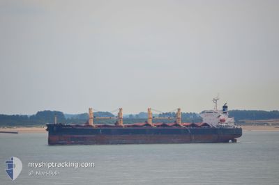
GENCO WARRIOR
Bulk Carrier
Current Trip
| Time Travelled | 24 days |
|---|---|
| Remaining Time | --- |
| Distance Travelled | 3473.92 nm |
| Remaining Distance | --- |
| AVG Speed | 10.7 Knots |
| MAX Speed | 16.1 Knots |
| AVG Wind | 10.9 knots |
| MAX Wind | 20 knots |
| MIN Temp | 20.5°C / 68.9°F |
| MAX Temp | 30.1°C / 86.18°F |
| Dybgang | 6.4 m |
| Position Modtaget | 2 m siden |
Current Position
| Longitude | -50.96672° |
|---|---|
| Latitude | 0.09217° |
| Status | At anchor |
| Fart | 0.1 Knots |
| Kurs | 225° |
| Område | North Atlantic Ocean |
| Station | T-AIS |
| Position Modtaget | 2 m siden |
Info
Information
The current position of GENCO WARRIOR is in North Atlantic Ocean with coordinates 0.09217° / -50.96672° as reported on 2024-05-13 01:47 by AIS to our vessel tracker app. The vessel's current speed is 0.1 Knots
The vessel GENCO WARRIOR (IMO: 9316153, MMSI: 538002808) is a Bulk Carrier that was built in 2005 ( 19 år gamle ). It's sailing under the flag of [MH] Marshall Is.
In this page you can find informations about the vessels current position, last detected port calls, and current voyage information. If the vessels is not in coverage by AIS you will find the latest position.
The current position of GENCO WARRIOR is detected by our AIS receivers and we are not responsible for the reliability of the data. The last position was recorded while the vessel was in Coverage by the Ais receivers of our vessel tracking app.
The current draught of GENCO WARRIOR as reported by AIS is 6.4 meters
Weather
| Temperature | 26.2°C / 79.16°F |
|---|---|
| Wind Speed | 7 knots |
| Direction | 60° ENE |
| Pressure | 1012.1 hPa |
| Humidity | 87.3 % |
| Cloud Coverage | 93 % |
Featured Company
Last Port Calls
| Port | Arrival | Departure | Time In Port |
|---|---|---|---|
| 2024-04-15 13:11 | 2024-04-18 09:07 | 2 d | |
| 2024-03-29 01:36 | 2024-04-09 06:07 | 11 d | |
| 2024-03-01 20:16 |
Most Visited Ports (Last year)
| Port | Arrivals | |
|---|---|---|
| 9 | ||
| 2 | ||
| 2 | ||
| 1 | ||
| 1 | ||
| 1 |
Last Trips
| Origin | Departure | Destination | Arrival | Distance | |
|---|---|---|---|---|---|
| 2024-04-09 01:07 | 2024-04-15 08:11 | 467.47 nm | |||
| 2024-03-01 23:16 | 2024-03-28 20:36 | 6632.58 nm |
Events
| Tid | Hændelsen | Detaljer | Position / Dest | Info |
|---|---|---|---|---|
| 2024-05-12 23:20 | Status er ændret | At anchor Default |
.08775 / -50.96781
SANTAREM
|
Fart: 0.3 kn Kurs: 37° |
| 2024-05-12 23:11 | Status er ændret | Default At anchor |
.08804 / -50.96859
SANTAREM
|
Fart: 0.3 kn Kurs: 42° |
| 2024-05-12 18:56 | Status er ændret | At anchor Default |
.09242 / -50.96691
SANTAREM
|
Fart: 0.1 kn Kurs: 194° |
| 2024-05-12 18:50 | Status er ændret | Default At anchor |
.09243 / -50.96687
SANTAREM
|
Fart: 0.1 kn Kurs: 208° |
| 2024-05-12 17:47 | Status er ændret | At anchor Default |
.09231 / -50.96642
SANTAREM
|
Fart: 0.1 kn Kurs: 218° |
| 2024-05-12 17:41 | Status er ændret | Default At anchor |
.09234 / -50.96643
SANTAREM
|
Fart: 0.1 kn Kurs: 218° |
| 2024-05-12 16:20 | Status er ændret | At anchor Default |
.09253 / -50.96602
SANTAREM
|
Fart: 0.9 kn Kurs: 196° |
| 2024-05-12 16:05 | Status er ændret | Default At anchor |
.09257 / -50.96624
SANTAREM
|
Fart: 0.8 kn Kurs: 232° |
| 2024-05-10 21:26 | STOP Sejllads | 6.17 nm, North East of MACAPA |
.08930 / -50.96976
SANTAREM
|
Fart: 0.3 kn Kurs: 97° |
| 2024-05-10 21:05 | Status er ændret | At anchor Under way using engine |
.08881 / -50.96784
SANTAREM
|
Fart: 0.4 kn Kurs: 83° |