
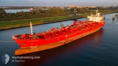
EASTERLY EAGLE
Oil/Chemical Tanker
Current Trip
BRSSZ
| Time Travelled | 10 h, 20 mins |
|---|---|
| Remaining Time | --- |
| Distance Travelled | 1.68 nm |
| Remaining Distance | --- |
| AVG Speed | 3.1 Knots |
| MAX Speed | 3.1 Knots |
| AVG Wind | 3 knots |
| MAX Wind | 3.3 knots |
| MIN Temp | 24.1°C / 75.38°F |
| MAX Temp | 24.3°C / 75.74°F |
| Dybgang | 10.5 m |
| Position Modtaget | 10 h, 5 m siden |
Current Position
| Longitude | -46.35788° |
|---|---|
| Latitude | -23.91857° |
| Status | Under way using engine |
| Fart | 2.4 Knots |
| Kurs | 280° |
| Område | South Atlantic Ocean |
| Station | T-AIS |
| Position Modtaget | 10 h, 5 m siden |
Info
Information
The current position of EASTERLY EAGLE is in South Atlantic Ocean with coordinates -23.91857° / -46.35788° as reported on 2024-04-30 04:12 by AIS to our vessel tracker app. The vessel's current speed is 2.4 Knots
The vessel EASTERLY EAGLE (IMO: 9423750, MMSI: 538003924) is a Oil/Chemical Tanker that was built in 2010 ( 14 år gamle ). It's sailing under the flag of [MH] Marshall Is.
In this page you can find informations about the vessels current position, last detected port calls, and current voyage information. If the vessels is not in coverage by AIS you will find the latest position.
The current position of EASTERLY EAGLE is detected by our AIS receivers and we are not responsible for the reliability of the data. The last position was recorded while the vessel was in Coverage by the Ais receivers of our vessel tracking app.
The current draught of EASTERLY EAGLE as reported by AIS is 10.5 meters
Weather
| Temperature | 27.9°C / 82.22°F |
|---|---|
| Wind Speed | 4 knots |
| Direction | 160° SSE |
| Pressure | 1014.6 hPa |
| Humidity | 59.3 % |
| Cloud Coverage | --- |
Featured Company
Last Port Calls
| Port | Arrival | Departure | Time In Port |
|---|---|---|---|
| 2024-04-30 03:38 | 2024-04-30 03:57 | 18 m | |
| 2024-04-05 11:40 | 2024-04-07 20:39 | 2 d | |
| 2024-04-03 23:54 | 2024-04-04 22:44 | 22 h | |
| 2024-04-01 21:12 | 2024-04-03 01:55 | 1 d | |
| 2024-03-29 03:07 | 2024-03-30 00:59 | 21 h | |
| 2024-03-25 13:57 | 2024-03-26 16:50 | 1 d | |
| 2024-03-10 19:19 | 2024-03-10 23:40 | 4 h | |
| 2024-02-17 09:24 | 2024-02-18 10:12 | 1 d | |
| 2024-02-10 13:38 | 2024-02-12 06:35 | 1 d | |
| 2024-02-06 07:31 | 2024-02-08 20:18 | 2 d |
Most Visited Ports (Last year)
| Port | Arrivals | |
|---|---|---|
| 8 | ||
| 3 | ||
| 3 | ||
| 2 | ||
| 2 | ||
| 2 |
Last Trips
| Origin | Departure | Destination | Arrival | Distance | |
|---|---|---|---|---|---|
| 2024-04-07 15:39 | 2024-04-30 00:38 | 5733.74 nm | |||
| 2024-04-04 17:44 | 2024-04-05 06:40 | 146.52 nm | |||
| 2024-04-02 20:55 | 2024-04-03 18:54 | 160.28 nm | |||
| 2024-03-29 19:59 | 2024-04-01 16:12 | 121.13 nm | |||
| 2024-03-26 11:50 | 2024-03-28 22:07 | 385.77 nm | |||
| 2024-03-10 18:40 | 2024-03-25 08:57 | 560.95 nm | |||
| 2024-02-18 07:12 | 2024-03-10 14:19 | 6368.87 nm | |||
| 2024-02-12 03:35 | 2024-02-17 06:24 | 116.98 nm | |||
| 2024-02-08 17:18 | 2024-02-10 10:38 | 175.70 nm | |||
| 2024-01-24 15:21 | 2024-02-06 04:31 | 3652.98 nm |
Events
| Tid | Hændelsen | Detaljer | Position / Dest | Info |
|---|---|---|---|---|
| 2024-04-30 04:25 | STOP Sejllads | 3.52 nm, North West of SANTOS |
-23.91938 / -46.36066
BRSSZ
|
Fart: Kurs: 280° |
| 2024-04-30 04:16 | Status er ændret | Default Under way using engine |
-23.91914 / -46.36002
BRSSZ
|
Fart: 2.4 kn Kurs: 280° |
| 2024-04-30 04:12 | Udenfor Dækning |
-23.91857 / -46.35788
South Atlantic Ocean
|
Fart: 2.4 kn Kurs: 262.9° |
|
| 2024-04-30 03:57 | Afsejlet fra sidste havn |
|
-23.92598 / -46.33214
BRSSZ
|
Fart: 8.5 kn Kurs: 295° |
| 2024-04-30 03:38 | Skibe i havn |
|
-23.95662 / -46.30477
[BR] SANTOS
|
Fart: 9.1 kn Kurs: 325.5° |
| 2024-04-30 03:32 | Destination er ændret | BRSSZ LAST UPDATE TIME |
-23.97041 / -46.29386
BRSSZ
|
Fart: 8.9 kn Kurs: 323.6° |
| 2024-04-30 03:32 | ETA er ændret | 2024/04/28 04:00 2024/04/11 16:14 |
-23.97041 / -46.29386
BRSSZ
|
Fart: 8.9 kn Kurs: 323.6° |
| 2024-04-30 03:23 | Status er ændret | Under way using engine Default |
-23.98927 / -46.29315
LAST UPDATE TIME
|
Fart: 7.2 kn Kurs: 60° |
| 2024-04-30 03:17 | Status er ændret | Default Under way using engine |
-23.99313 / -46.30602
LAST UPDATE TIME
|
Fart: 10.2 kn Kurs: 72.4° |
| 2024-04-30 03:09 | Status er ændret | Under way using engine Default |
-23.99502 / -46.32869
LAST UPDATE TIME
|
Fart: 10.2 kn Kurs: 24° |