
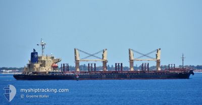
AFRICAN GANNET
Cargo
Current Trip
| Time Travelled | 6 days |
|---|---|
| Remaining Time | --- |
| Distance Travelled | 1591.87 nm |
| Remaining Distance | --- |
| AVG Speed | 11.2 Knots |
| MAX Speed | 13.2 Knots |
| AVG Wind | 7.1 knots |
| MAX Wind | 16 knots |
| MIN Temp | 25.4°C / 77.72°F |
| MAX Temp | 29.8°C / 85.64°F |
| Dybgang | 10.2 m |
| Position Modtaget | 4 d siden |
Current Position
| Longitude | 57.31540° |
|---|---|
| Latitude | 24.97828° |
| Status | Under way using engine |
| Fart | 12.2 Knots |
| Kurs | 121.3° |
| Område | Gulf of Oman |
| Station | T-AIS |
| Position Modtaget | 4 d siden |
Info
Information
The current position of AFRICAN GANNET is in Gulf of Oman with coordinates 24.97828° / 57.31540° as reported on 2024-04-22 23:35 by AIS to our vessel tracker app. The vessel's current speed is 12.2 Knots and is heading at the port of ADELAIDE. The estimated time of arrival as calculated by MyShipTracking vessel tracking app is 2024-05-14 12:00 LT
The vessel AFRICAN GANNET (IMO: 9749233, MMSI: 311000813) is a Cargo It's sailing under the flag of [BS] Bahamas.
In this page you can find informations about the vessels current position, last detected port calls, and current voyage information. If the vessels is not in coverage by AIS you will find the latest position.
The current position of AFRICAN GANNET is detected by our AIS receivers and we are not responsible for the reliability of the data. The last position was recorded while the vessel was in Coverage by the Ais receivers of our vessel tracking app.
The current draught of AFRICAN GANNET as reported by AIS is 10.2 meters
Weather
| Temperature | 29.6°C / 85.28°F |
|---|---|
| Wind Speed | 7 knots |
| Direction | 350° N |
| Pressure | 1007.7 hPa |
| Humidity | 66.8 % |
| Cloud Coverage | 100 % |
Featured Company
Last Port Calls
| Port | Arrival | Departure | Time In Port |
|---|---|---|---|
| 2024-04-15 07:35 | 2024-04-20 21:16 | 5 d | |
| 2024-04-13 19:48 | 2024-04-14 12:00 | 16 h | |
| 2024-04-08 17:33 | 2024-04-10 22:45 | 2 d | |
| 2024-03-15 04:02 | 2024-03-16 08:38 | 1 d | |
| 2024-03-15 02:10 | 2024-03-15 03:22 | 1 h | |
| 2024-03-02 02:19 | |||
| 2024-02-11 23:01 | 2024-02-15 10:31 | 3 d | |
| 2024-02-08 10:33 | 2024-02-09 08:17 | 21 h | |
| 2024-02-04 11:08 | 2024-02-05 22:49 | 1 d |
Last Trips
| Origin | Departure | Destination | Arrival | Distance | |
|---|---|---|---|---|---|
| 2024-04-14 16:00 | 2024-04-15 11:35 | 211.22 nm | |||
| 2024-04-11 01:45 | 2024-04-13 23:48 | 328.99 nm | |||
| 2024-03-16 16:38 | 2024-04-08 20:33 | 5397.54 nm | |||
| 2024-03-15 11:22 | 2024-03-15 12:02 | 3.92 nm | |||
| 2024-03-15 11:22 | 2024-03-15 10:10 | 3.92 nm | |||
| 2024-02-15 21:31 | 2024-03-02 09:19 | 3348.79 nm | |||
| 2024-02-09 19:17 | 2024-02-12 10:01 | 267.93 nm | |||
| 2024-02-06 09:49 | 2024-02-08 21:33 | 225.34 nm | |||
| 2024-01-24 20:16 | 2024-02-04 22:08 | 1281.81 nm |
Events
| Tid | Hændelsen | Detaljer | Position / Dest | Info |
|---|---|---|---|---|
| 2024-04-22 23:40 | Status er ændret | Default Under way using engine |
24.96902 / 57.33193
AU ADL
|
Fart: 12.2 kn Kurs: 121.3° |
| 2024-04-22 23:35 | Udenfor Dækning |
24.97828 / 57.31540
Gulf of Oman
AU ADL
|
Fart: 12.2 kn Kurs: 121.3° |
|
| 2024-04-22 23:20 | Ændre havområde | Iranian part of the Gulf of Oman Omani part of the Gulf of Oman |
25.00474 / 57.26741
Gulf of Oman
AU ADL
|
Fart: 11.9 kn Kurs: 121.5° |
| 2024-04-22 22:20 | Ændre havområde | Omani part of the Gulf of Oman United Arab Emirates part of the Gulf of Oman |
25.10112 / 57.08144
Gulf of Oman
AU ADL
|
Fart: 11.6 kn Kurs: 119.6° |
| 2024-04-22 19:37 | START Sejllads | 11.05 nm, East of FUJAIRAH |
25.19524 / 56.56068
AU ADL
|
Fart: 3.1 kn Kurs: 125° |
| 2024-04-22 19:29 | Status er ændret | Under way using engine At anchor |
25.19713 / 56.55606
AU ADL
|
Fart: 1 kn Kurs: 136° |
| 2024-04-22 19:03 | Dybgangen er ændret | 10.2 10 |
25.19805 / 56.55431
AU ADL
|
Fart: 0.1 kn Kurs: 158° |
| 2024-04-22 17:47 | Destination er ændret | AU ADL AE FJR |
25.19835 / 56.55433
AU ADL
|
Fart: Kurs: 160° |
| 2024-04-22 17:47 | ETA er ændret | 2024/05/14 12:00 2024/04/22 04:00 |
25.19835 / 56.55433
AU ADL
|
Fart: Kurs: 160° |
| 2024-04-22 14:17 | Status er ændret | At anchor Default |
25.19800 / 56.55461
AE FJR
|
Fart: Kurs: 164° |